Maps of Mediterranean Sea

Southern & Middle Europe.
1 : 7920000 Goodrich, S.G.
Ost- und Mitteleuropa i.d. zweiten Hälfte d. 18. Jahrhunderts. Die polnischen Teilungen
1 : 12000000 Polen-Litauen, Ostmitteleuropa, Teilungen Polens
Národopisná mapa Evropy
Evropa Ryšavý, Jaroslav Mollo, Tranquillo
Turkey, in Europe and Hungary, from the best authorities.
from Carey's general atlas, improved and enlarged : being a collection of maps of the world and quarters, their principal empires, kingdoms, &c.
Esquisse d’une marche générale des Slaves, du pays des Sauromates vers l’Occident et le Nord-Ouest de l’Europe, du 5e siècle avant notre ère jusqu’au 8e siècle de notre ère
Europa Sarmaten Slawen Völkerwanderungszeit
Střední Evropa a Přední Asie za časů III. války křížové
Geschäftsverbindungen und Kupferhandel der Medici 1393-1395
Europa Medici, Bankiers, Fuersten, Italien
Tabula Europae VIII. [Karte], in: Claud. Ptolemaeus. Geographia lat. cum mappis [...], S. 275.
1 Karte aus Atlas Münster, Sebastian [und Ptolemaeus, Claudius]
Nordischer Krieg 1700 - 1721
Ostmitteleuropa, Nordeuropa, Nordischer Krieg <1700-1721>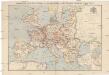
Compagnie Internationale des Wagons-lits et des Grands Express européens
1 : 4500000 Evropa L. Hermann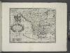
A new map of Turky in Europe and parts adjoyning shewing their principal divisions and chief cities, towns, rivers, mountains &c.
from A new sett of maps both of antient and present geography : wherein not only the latitude and longitude of many places are corrected according to the latest observations, but also the most remarkable differences of antient and present geography may be quickly discern'd by a bare inspection or comparing of correspondent maps, which seems to be the most natural and easy method to lead young students (for whose use the work is principally intended) unto a competent knowledge of the geographical science : together with a geographical treatise particularly adapted to the use and design of these maps / by Edward Wells, M.A. and student of Christ-Church, Oxon.
Eastern Europe - communications.
1 : 5300000 John Bartholomew and Son
Tabula Moderna Sarmatie Eur. Sive Hungarie, Polonie, Russie, Prussie Et Walachie [Karte], in: Claudii Ptolemei viri Alexandrini mathematice discipline philosophi doctissimi geographie opus [...], S. 248.
1 Karte aus Atlas Waldseemüller, Martin [und Ptolemaeus, Claudius] Übelin, Georg
Verbreitung der Slaven um 900
Osteuropa Slawen Anton, J.
Europa im Zeitalter Napoleons
1 : 15000000 Europa Napoleon I., Frankreich, Kaiser
Oesterreichisch-russisch-türkischer Kriegsatlas
1 : 1500000 Evropa jižní Šimek, Maxmilian F. A. Schraembl
Völkerkarte von Mittel-und Südosteuropa
1 : 15000000 Mitteleuropa, Südosteuropa, ethnische Gruppe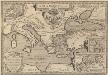
Argonautica. [Karte] [Europa.], [Thessalia und Umgebung], [Hellespontus, Phryxeum aequor, et Athamantidis fluenta.] [3 Nebenkarten], in: Theatrum orbis terrarum, S. 538.
1 Karte aus Atlas Ortelius, Abraham Vrients, Jan Baptista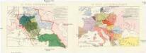
Conseil national des pays Tcheques
Evropa Conseil National des Pays Tcheques
Map of the Austrian Empire, Italian States, Turkey in Europe, and Greece ; Maltese Islands [inset]
from New general atlas.
Charte von Ungarn, den russisch- oesterreich- und presussischen- Besitzungen im ehemal. Polen, ingl. dem Schwarzen meer und der Türkey
1 : 4160000 Evropa jihovýchodní Utz, Georg Friedrich Anville, Jean-Baptiste Bourguinon d' Kunsthandl. A.G. Schneider u. Weigels
Imperii Orientalis et Circumjacentium Regionum.
1 : 4500000 L'Isle, Guillaume de, 1675-1726
Imperii Orientalis et Circumjacentium Regionum.
1 : 4500000 L'Isle, Guillaume de, 1675-1726
Europe 3.
1 : 2800000 Anville, Jean Baptiste Bourguignon d, 1697-1782
Carte Nouvelle du Royaume de Pologne
Mollova mapová sbírka Bonne, Rigobert Lotter, Matthaus Albrecht
Střední a jihovýchodní Europa v druhé polovici XIV. stol.

Totius Danubii
1 : 4000000 Mollova mapová sbírka Böhme, August Gottlob Dorn, Sebastian Homann, Johann Baptista - dědici
Oorlogskaart van Europa : met vermelding der voornaamste gebeurtenissen van af 28 juni 1914 tot 29 januari 1916 / samengest. en get. door Ph.L. Battefeld
1 : 2600000 Annotatie: Met lijst van: Datums en feiten; Annotatie geografische gegevens: Met schaalstok Ph.L. Battefeld Delft : Hillen's Sigaren en Tabaksfabriek / (Amsterdam : drukkerij Senefelder)
Karta razselenija [sic] Slavjan v IX stol
1 : 12600000 Evropa východní Kočubinskij, Aleksandr Aleksandrovič C.I. Mal'cov