Maps of Kamouraska (MRC)

Composite: Lower Canada eastern
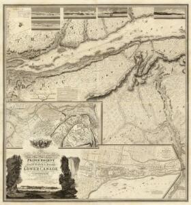
1 : 174240 Faden, William, 1750?-1836
(This Topographical map of the Province of Lower Canada. Sheet) D.
1 : 174240 Faden, William, 1750?-1836
Edmundston
1 : 250000
Edmundston
1 : 250000
Allagash
1 : 100000
Montmagny
1 : 100000
Clayton Lake
1 : 100000
Allagash Falls
1 : 50000
Allagash Falls
1 : 50000
Depot Lake
1 : 62500
Depot Lake
1 : 62500
Seven Islands
1 : 62500
Seven Islands
1 : 62500
Seven Islands
1 : 62500
Round Pond
1 : 62500
Round Pond
1 : 62500
Round Pond
1 : 62500
Round Pond
1 : 62500
Round Pond
1 : 62500
Allagash Falls
1 : 62500
Allagash Falls
1 : 62500
Fish River Lake
1 : 62500
Fish River Lake
1 : 62500
Fish River Lake
1 : 62500
Allagash Falls
1 : 62500
Allagash Falls
1 : 62500
Allagash Falls
1 : 62500
Allagash Falls
1 : 48000
Fish River Lake
1 : 62500
Fish River Lake
1 : 62500
Fish River Lake
1 : 62500