Maps of New York

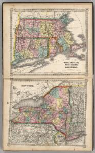
Massachusetts, Rhode Island, and Connecticut. New York.
1 : 1000000 Schonberg & Co.
Karte von Neu England, Neu Yorck und Pensilvanien
Geological Map
from New topographical atlas and gazetteer of New York, comprising a topographical view of the several counties of the state, ... including ... map of the United States and territories ... Compiled from the latest astronomical observations, official surveys and records of the United States and territories ...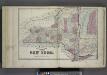
Plan of The State of New York.
from Atlas of Steuben County, New York : from actual surveys and official records / compiled & published by D.G. Beers & Co.
Map of the state of New York with part of Upper Canada / engraved & printed by Fenner Sears & Co.
from Whole
Map shewing the rail roads between Lake Erie, New York & Boston : intended to illustrate the importance of the N. York & Erie Rail Road / J.F. Smith, del.
from Whole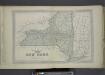
Plan of The State of New York.
from County atlas of Orange, New York / from actual surveys by and under the direction of F.W. Beers.
Carte des Provines Septles. des Etats-Unis.
1 : 2400000 Marshall, John
A map of New England and New York

Map of the state of New-York and the surrounding country / by David H. Burr; engd. by Rawdon, Clark & Co., Albany, & Rawdon, Wright & Co., New York.; An atlas of the state of New York: containing a map of the state and of the several counties / by David H. Burr.
from An atlas of the state of New York : containing a map of the state and of the several counties / by David H. Burr. Burr, David H.; Rawdon, Clark & Co.; Rawdon, Wright & Co.; Stone & Clark Republishers,
Map of the state of New-York and the surrounding country / by David H. Burr; engd. by Rawdon, Clark & Co., Albany, & Rawdon, Wright & Co., New York.; An atlas of the state of New York, designed for the use of engineers, containing a map of the state and of the several counties. / Projected and drawn ... under the superintendence and direction of Simeon de Witt.
from An atlas of the state of New York, designed for the use of engineers, containing a map of the state and of the several counties. / Projected and drawn ... under the superintendence and direction of Simeon de Witt. Burr, David H.; De Witt, Simeon; Rawdon, Clark & Co.; Rawdon, Wright & Co.; Stone & Clark Republishers,
Map of the state of New-York and the surrounding country / by David H. Burr; engd. by Rawdon, Clark & Co., Albany, & Rawdon, Wright & Co., New York.; An atlas of the state of New York: containing a map of the state and of the several counties. / Projected and drawn under the superintendence and direction of Simeon de Witt ... And also the physical geography of the State ...
from An atlas of the state of New York : containing a map of the state and of the several counties. / Projected and drawn under the superintendence and direction of Simeon de Witt ... And also the physical geography of the State ... Burr, David H.; De Witt, Simeon,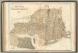
New York, Vermont, New Hampshire, Rhode Island, Massachusetts & Connecticut.
1 : 1570000 Black, Adam & Charles
Map of the interior travels through America, delineating the march of the army
Lines and Metallic Circuit Connections.
1 : 2534400 American Telephone and Telegraph Company
Map of the state of New York : compiled from the latest authorities.
from Whole
New York.
1 : 3674880 Scott, Joseph
State of New York.
1 : 300000 French, C.E.
Map of the State of New York / J.H. Young.
from Whole
The north eastern part of the United States / drawn and engraved by W. Hughes.
from Parts W. Hughes.,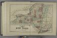
Plan of the State of New York.
from Atlas of Madison County, New York : from actual surveys / by and under the direction of D. G. Beers.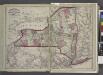
Railroads of the state.
from New topographical atlas and gazetteer of New York, comprising a topographical view of the several counties of the state, ... including ... map of the United States and territories ... Compiled from the latest astronomical observations, official surveys and records of the United States and territories ...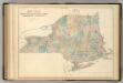
New York and New England.
1 : 1580000 Hughes, William
Map of the state of New York : showing the boundaries of counties & townships, the location of cities, towns and villages, the courses of rail roads, canals & stage roads / by J. Calvin Smith ; engraved on steel by Sherman & Smith.
from Whole
Map of the state of New York : compiled from the latest authorities.
from Whole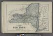
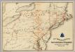
Plan of the State of New York.
from County atlas of Cayuga, New York. From recent and actual surveys and records under the superintendence of F. W. Beers.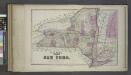
Plan of the State of New York.
from Atlas of Columbia County, New York. From actual surveys and official records. Compiled & published by D. G. Beers & Co.
Map of the meetings constituting New York Yearly Meeting of Friends.
from Whole
New York / by H.S. Tanner ; engraved ... by H.S. Tanner.
from Whole