Maps of Switzerland

Die Schweiz.
1 : 800000 Stein, Christ. Gottfr. Dan.
Historischer Atlas der Schweiz
1536 - 1650 Mandrot, Louis-Alphonse de Deutsche Buchhandlung von J. Kessmann
Historischer Atlas der Schweiz
1501 - 1536 Mandrot, Louis-Alphonse de Deutsche Buchhandlung von J. Kessmann
Helvetia
1 : 1700000 1 Karte [von Heinrich Heidegger] [bey Orell, Füssli und Compagnie], [Zürich]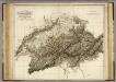
Switzerland.
1 : 615000 Playfair, Principal
Carte ancienne de la Suisse
1 Karte : Kupferdruck ; 19 x 19 cm, Bildgrösse 36 x 45 cm Châtelain s.n.
Carte physique et politique de la Suisse
1 Karte : Kupferdruck ; 31 x 42 cm Mentelle; Chanlaire; Blondeau chez les auteurs P. G. Chanlaire rue Geoffroy-Langevin no. 328, et E. Mentelle cour du Louvre no. 7
Suisse.
1 : 745000 Picquet, C.
Karte der Schweiz von 1657
1 : 500000 Originaltitel: Helvetiae, Rhaetiae et Valesiae caeterorumque Confoederatorum ut et finitimorum Populorum. Tabula Geographica et Hydrographica nova et exacta. Neudruck (mittels revidierter und teilweise nachgestochener Kupferplatten) der von Hans Conrad Gyger, andere Schreibweisen: Geiger, Geyger, (1599-1674), Kartograf, Ingenieur und Amtmann des Amts Kappelerhof, von Zürich, gezeichneten und von Conrad Meyer (1618-1689), Maler, Zeichner und Radierer, von Zürich, gestochenen Originalkarte. Mit (am linken und rechten Bildrand) farbigen Wappen der Dreizehnörtigen Eidgenossenschaft sowie der elf Zugewandten Orte und mit (am linken unteren Bildrand) den Wappen der neuen Gemeinen Herrschaften Baden, Frauenfeld, Freiämter, Sargans, Rheintal, Lugano, Locarno, Mendrisio und Meinthal. Mit einer Erklärung der Zeichen. Karte aus zwei zusammensetzbaren Blättern (zwei Kupferdruckplatten). Gyger, Hans Georg (1627-1687), Maler und Amtmann des Klosteramts Küsnacht, von Zürich
Les Suisses Leurs Alliez Auec les Sujets des Suisses, et des Alliez
1 : 750000 Mollova mapová sbírka Du Tralage, Jean Nicolas Nolin, Jean Baptiste II.
Übersichtskarte des schweizerischen Pegel und Witterungsstationennetzes
1 : 600000 Topogr. Anstalt v. Wurster, Randegger & Cie
Exactissima Helvetiae, Rhaetiae, Valesiae caeterorumq. confoederatorum ut et finitimorum populorum regionum tabula
1 Karte ex conatibus Nicolai Visscher ; A. Hogeboom sculp. Visscher, [Amsterdam]
Switzerland and the county of the Grisons, wherein is described the XIII Switz Cantons with their allies & c
1 : 760000 humbly inscrib'd to [...] the Marquiss of Harold & c. rev. by J. Senex [London] : [Brown]

Switzerland.
1 : 910000 Society for the Diffusion of Useful Knowledge (Great Britain)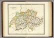
Switzerland.
1 : 955000 Teesdale, Henry
Sud-West Deutschland Und Schweiz. Sudlicher Theil.
1 : 925000 Vogel, C.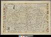
Helvetiae, Rhaetiae et Valesiae caeterorumque confoederatorum ut & finitimorum populorum tabula geographica et hydrographica nova & exacta
1 : 470000 1 Karte operâ & studio Ioh. Conradi Gygeri delineata & à Conrado Meyero in aes incisa, anno Christi 1657 [Verlag nicht ermittelbar], [Zürich]
Novissima Foederatorum HELVETIORUM Tabula
1 : 2600000 Švýcarsko
Switzerland.
1 : 1000000 Colton, G.W.
Die Schweiz.
1 : 1400000 Reichard, C. G.
Exactissima Helvetiae Rhaetiae, Valesiae caeterorumq. confoederatorum ut et finitimorum populorum regionum tabula / ex conatibus Nicolaum Visscher Amst. Bat. ; A. Hogeboom sculp
1 : 800000 Annotatie: Cum privil. praepotentiss. Ordinum General. Belgii Foederati; Met opdracht van Nicolaus Visscher; Origineel is Blad 117 in atlas factice; Annotatie geografische gegevens: Met 5 schaalstokken; Legenda Nicolaes Jansz. Visscher jr. 1649-1702; Andries Hogeboom fl. 1665-1682 Amst. Bat. : ex conatibus Nicolai Visscher
Nova Helvetiae tabula geographica illustrissimis et potentissimis cantonibus et rebuspublicis reformatae religionis Tigurinae, Bernensi, Glaronensi, Basiliensi, Scaphusianae, Abbatis Cellanae
1 : 230000 1 Karte auf 4 Bl. dominis suis clementissimis humillime dicata a Ioh. Iacobo Scheuchzero Tigurino ; Ioh. Melch. Füsslin ornamenta pinx. ; Ioh. Henr. Huber et Eman. Schalch sculps. [Verlag nicht ermittelbar], [Zürich]
[Süd-West Deutschland und Schweiz, Südlicher Theil]
Hand-Atlas über alle Theile der Erde und über das Weltgebäude Stieler, Adolf Justus Perthes
Exactißima Helvetiae Rhaetiae, Valesiae caeterorumq[ue] confoederatorum ut et finitimorum populorum regionum tabula
1 : 760000 Raetie Visscher, Nicolaus Hogeboom, Andries ex conatibus Nicolai Visscher
Exactißima Helvetiae Rhaetiae, Valesiae caeterorumq. confoederatorum ut et finitimorum populorum regionum tabula
Švýcarsko Visscher, Nicolaus Hogeboom, Andries ex conatibus Nicolai Visscher
<<Die>> Eydgnoschafft mit dero Grentzen
1 : 2000000 1 Karte Hans Conradt Geiger delinea. ; Con. Meyer sc. [J.J. Bodmer], [Zürich]
Reliefkarte der Schweiz
Originaltitel: Nova Helvetiae Tabula geographica Illustrissimis et Potentissimis Cantonibus et Rebuspublicis Reformatae Religionis Tigurinae, Bernensi, Glaronensi, Basilensi, Scaphusianae, Abbatis cellanae. Scheuchzer, Johann Jakob (1672-1733), Arzt und Naturforscher, von Zürich
Helvetiae, Rhaetiae et Valesiae caeterorumque confoederatorum ut & finitimorum populorum tabula geographica et hydrographica nova & exacta
1 : 500000 1 Karte operâ & studio Ioh. Conradi Gygeri delineata & à Conrado Meyero in aes incisa, anno Christi 1657 [Verlag nicht ermittelbar], [Zürich]


