Maps of Canada
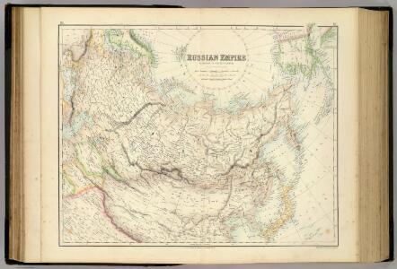
Russian Empire.
1 : 19008000 Fullarton, A. & Co.
Russische Reich.
1 : 14300000 Weiland, C. F. (Carl Ferdinand), d. 1847
Das Russische Reich nach seinen ethnographischen.
1 : 25720000 Berghaus, Heinrich
Amerique septentrionale divisée en ses principales parties: ou sont distingués les vns des autres les estats suivant qu'ils appartiennent presentemet aux François, Castillans, Anglois, Suedois, Danois, Hollandois / tirée des relations de toutes ces nations par le Sr. Sanson, geographe ordinaire du Roy; Cordier, sculps?
from Whole Sanson,
Amerique septentrionale divisée en ses principales parties: ou sont distingués les vns des autres les estats suivant qu'ils appartiennent presenteme[n]t aux François, Castillans, Anglois, Suedois, Danois, Hollandois, tirée des relations de toutes ces nations / par le Sr. Sanson, geographe ordinaire du Roy.
from John H. Levine Collection Sanson,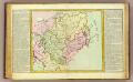
La Tartarie.
1 : 20000000 Clouet, J. B. L. (Jean-Baptiste Louis), b. 1730
Charte das Russische Reich und die von den Tatarn bewohnte Länder in Europa und Asia enthaltend / e
1 : 16000000 1 Karte : Kupferdruck ; 44 x 59 cm Güssefeld, Franz L. bey den Homännischen Erben
Nova mappa generalis totius orbis amplissimae Russorum monarchiae
1 : 22800000 Asie Probst, Johann Michael Probst, Johann Georg Iohann Michael Probst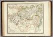
Russia in Asia and Tartary.
1 : 19300000 Teesdale, Henry
Nova Tabula Imperii Russici / ex omnium accuratissimis. quae hactenus extiterunt, Imprimis viri Ampl
1 : 12800000 1 Karte : Kupferdruck ; 49 x 66 cm Droogenham, Gerrit Franciscus Halma
Generalis totius imperii Russorum novissima tabula
1 : 12500000 Japonské moře Homann, Johann Baptist ex conatibus Iohannis Baptistae Homanni
Amerique septentrionale divisée en ses principales parties.
from John H. Levine Collection [s.n.]: A Paris; Jaillot, Charles Hubert Alexis,
Amerique septentrionale divisée en ses principales parties.
from John H. Levine Collection [s.n.]: A Paris; Jaillot, Charles Hubert Alexis,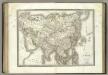
L'Asie.
1 : 24000000 Lapie, M. (Pierre), 1779-1850
Asia.
1 : 31680000 Colton, G.W.
Ueberfahrts-Karte.
1 : 30000000 Radefeld, Carl Christian Franz, 1788-1874
North America divided into its principall parts where are distinguished the severall states which belong to the English, Spanish, and French / described by Sanson; corrected and amended by William Berry.; [A collection of maps of the world] / [described by Sanson; corrected and amended by William Berry.]
from Collection of maps, 1680-1690 Berry, William; Morden, Robert; Petty, William, Sir; Sanson, Nicolas; Slaney, Edward,
Tartary.
1 : 23000000 Lucas, Fielding Jr.
L'Amerique Septentrionale.
1 : 19000000 Lapie, M. (Pierre), 1779-1850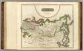
Russian Empire.
1 : 15500000 Thomson, John
Amerique septentrionale divisée en ses principales parties.
from Whole Chés Ian Bt. Elwe: Amsterdam; Elwe, Jan Barend,
Amerique septentrionale divisée en ses principales parties.
from Whole Chés Ian Bt. Elwe: Amsterdam; Elwe, Jan Barend,
L'Asie, 1227 a 1840.
1 : 43000000 Houze, Antoine Philippe
Russian empire / N.R. Hewitt ; drawn and engraved for Thomson's new general atlas
1 : 14500000 1 Karte : Kupferdruck ; 47 x 61 cm Hewitt, N.R. Thomson
L'Asie, l'an 1220 ap. J.C.
1 : 43000000 Houze, Antoine Philippe
Ueberfahrts-Karte
Grosser Hand-Atlas über alle Theile der Erde in 170 Karten Meyer, J. Verlag des Bibliographischen Instituts
Amerique septentrionale / par N. Sanson d'Abbeville, geog. du Roy; A. Peyrounin, sculp.
from Whole N. Sanson; A. Peyrounin,
Carte nouvelle de tout l'empire de la Grande Russie dans l'estat ou il s'est trouvé à la mort de P
1 : 13400000 1 Karte : Kupferdruck ; 46 x 64 cm [Verlag nicht ermittelbar]