Maps of Netherlands

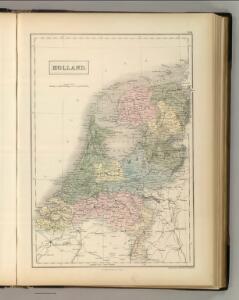
Holland.
1 : 1048000 Hughes, William
Karte der itzo vereinigten Niederlande
1 : 990000 Nizozemsko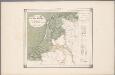
25. Nederland : de dijken weggedacht ..., uit: Geologische kaart van Nederland / door W.C.H. Staring ; bew. aan de Topographische Inrichting
1 : 200000 Winand Carel Hugo Staring 1808-1877; Topographische Inrichting, 's-Gravenhage 's-Gravenhage : Belinfante
Seven United Provinces.
1 : 1460000 Bowen, Frances
Foederatae Belgicae tabvla
1 : 728000 Limburg (Belgie) Wit, Frederick de F. de Wit
Proef eener geologische kaart van de Nederlanden
1 : 800000 door W.C.H. Staring op steen geteekend en gegraveerd door J.Jaeger. Groningen : J. Oomkens Jz
Holland.
1 : 1290000 Finley, Anthony
A new and correct map of the seven provinces : drawn from the most approved maps and charts : the whole being regulated by astronomical observations
1 : 920000 by Eman Bowen. [London] : Tyndal
Nieuwe kaart der Vereenigde Nederlanden
1 : 900000 Amsterdam : by Isaak Tirion
Belgium foederatum / emendatius auctum et novissimé editum per Iustinum Danckerts Amstelodami
1 : 500000 Annotatie: Cum privil. Ordin. Holl. et Westfrisiae; Annotatie geografische gegevens: Met 2 schaalstokken Justus Danckertsz 1635-1701 [Amsterdam : Justus Danckerts]
Belgica foederata complectens septem provincias, ducatum Geldriae, comitatus Hollandiae et Zeelandiae dioec. traject. transisul. Groningam et Frisiam et circumjacentes provincias mappa geographica
1 : 610000 Belgie Lotter, Tobias Conrad per Tobia[m] Conr. Lotter
Belgica foederata complectens septem provincias, ducatum Geldriae, comitatus Hollandiae et Zeelandiae dioec. traject. transisul. Groningam et Frisiam et circumjacentes provincias mappa geographica
1 : 610000 Belgie Lotter, Tobias Conrad Lotter, Matthäus Albrecht per Tobia[m] Conr. Lotter
Pays-Bas.
1 : 700000 Vivien St Martin, L.
Belgium Foederatum mendatè auctum et novissimè editum [Karte], in: Novus atlas absolutissimus, Bd. 3, S. 165.
1 Karte aus Atlas Janssonius Offizin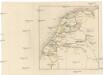
[Nizozemsko]
Nizozemsko Bilderdyk, W Veelwaard, D.
Provinces Vnies de Pays Bas
1 : 861000 Nizozemsko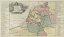
Descriptio veteris Agri Batavi et Frisi omnisque regionis quae hodie est in dicione VII. Foederatorvm cis et ultra Rhenvm
1 : 1100000 Mollova mapová sbírka Alting, Menso
Bladwijzer van de kaarten op de schaal van 1:25 000, 1:50 000 en 1:200 000
1 : 600000 Nizozemsko Topogr. Inrichting
Charte der Hollaendischen départemens
Nizozemsko Kipferling, Karl Joseph Krayenhoff, Cornelius Rudolphus Theodorus J. Riedl's Kunsthandung
Charte der Hollaendischen départemens
Nizozemsko Krayenhoff, Cornelius Rudolphus Theodorus Verlage des Kunst und Industrie
Belgium foederatum
1 : 640000 Indonésie Seutter, Matthäus studio [Mattha]ei Seutteri
Kaart der bosschen in Nederland / bewerkt door H. Blink ; uitgegeven door de afdeeling Amsterdam der Nederlandsche Heidemaatschappij, met subsidie van het hoofdbestuur
1 : 400000 Annotatie: Met lijst: Gemeenten, waar de uitgestrektheid der bosschen 20 en meer procent van de oppervlakte bedraagt; Annotatie geografische gegevens: Legenda Hendrik Blink 1852-1931; Nederlandsche Heidemaatschappij. Afdeeling Amsterdam [Amsterdam : Afdeeling Amsterdam der Nederlandsche Heidemaatschappij] / ('s-Hage : lithographie en kleurendruk van J. Smulders & C°.)
Republik der Vereinigten Niederlande Innerer Aufbau 1648
Niederlande Verwaltungsgliederung Kunz, Andreas ; Moeschl, Joachim Robert
Holland.
1 : 1330560 Tallis, J. & F.
Belgica Foederata
1 : 610000 Mollova mapová sbírka Lotter, Tobias Conrad Lotter, Tobias Conrad
5 & 9. Hoogtekaart van Nederland, uit: Geologische kaart van Nederland / door W.C.H. Staring ; bew. aan de Topographische Inrichting
1 : 200000 Winand Carel Hugo Staring 1808-1877; Topographische Inrichting, 's-Gravenhage 's-Gravenhage : Belinfante
La republica Battava
1 : 2400000 Nizozemsko Zatta, Antonio Zatta
Overzichtskaart van den Topographischen atlas van het Koningrijk der Nederlanden op de schaal van 1:200.000
1 : 1000000 titelvariant: Bladwijzer van den Topographischen atlas van het Koninkrijk der Nederlanden op de schaal van 1:200.000; Topographische atlas van het Koningrijk der Nederlanden op de schaal van 1:200.000; Annotatie: Omslagtitel: Bladwijzer van den Topographischen atlas van het Koninkrijk der Nederlanden op de schaal van 1:200.000 ['s-Gravenhage : Topographische Inrichting]
Holland.
1 : 1300000 Darton, William