Maps of Montgomery County

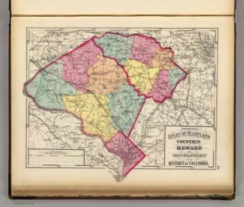
Topographical atlas of Maryland: counties of Howard and Montgomery and D.C.
1 : 221760 Walling, H. F.
Montgomery.
1 : 221760 Martenet, Simon J.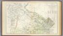
N.E. Virginia, Washington 1.
1 : 126720 Young, J. J.
Map Of N. Eastern Virginia And Vicinity Of Washington
1 : 63360 U.S. War Department, Topographical Engineers
Frederick
1 : 125000
Frederick
1 : 125000
Frederick
1 : 125000
Frederick
1 : 125000
Frederick
1 : 125000
Frederick
1 : 125000
Geographical, statistical, and historical map of the District of Columbia / engraved by Young & Delleker.
from Charts and maps
Territory of Columbia
Ellicott, Andrew, 1754-1820 s.n.
Shell Washington D.C. and Vicinity.
1 : 76032 Shell Oil Company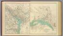
Washington, Richmond.
United States. War Dept. Engineer Bureau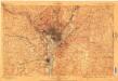
Washington
1 : 62500
Washington
1 : 62500
Laurel
1 : 62500
Laurel
1 : 62500
Seneca
1 : 62500
Rockville
1 : 62500
Laurel
1 : 62500
Laurel
1 : 62500
Laurel
1 : 62500
Laurel
1 : 62500
Laurel
1 : 62500
Rockville
1 : 62500
Rockville
1 : 62500
Rockville
1 : 62500
Rockville
1 : 62500
Seneca
1 : 62500
Seneca
1 : 62500
Seneca
1 : 62500
Seneca
1 : 62500
Seneca
1 : 62500
Seneca
1 : 62500
Seneca
1 : 62500
Rockville
1 : 62500
Rockville
1 : 62500
Rockville
1 : 62500
Laurel
1 : 62500
Laurel
1 : 62500
Laurel
1 : 62500
Laurel
1 : 62500
Laurel
1 : 62500
Laurel
1 : 62500
Laurel
1 : 62500
Laurel
1 : 62500