Maps of Minas Gerais

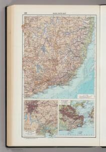
229. Brazil, South East, Sao Paulo Region, Rio de Janeiro. The World Atlas.
1 : 3750000 USSR (Union of Soviet Socialist Republics).
Mapa geologico do estado de Minas Geraes
1 : 1000000 Guimarães, Djalma Belo-Horizonte : Imprensa Official
Partie du Bresil. Amer. Merid. 28.
1 : 1641836 Vandermaelen, Philippe, 1795-1869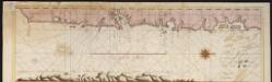
Een gedeelte van de kust van Brazilia tussen Rio das Contas en Cabo St. Thome [south part]
Brazil Gerard van Keulen
Map of the principal Mining District of the Province of Minas Geraes in the Empire of Brazil
Map of the principal Mining District of the Province of Minas Geraes in the Empire of Brazil. Lithographed by J. Netherclift. [London]
South America N.E. 45
1 : 7500000 Appleton, D. & Co.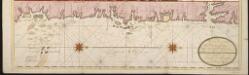
Een gedeelte van de kust van Brazilia tussen Rio das Contas en Cabo St. Thome [north part]
Brazil Gerard van Keulen
Pirassununga
1 : 100000 Comissão Geográfica e Geológica. São Paulo, Brésil São Paulo : Hartmann & Reichenbach
Casa Branca
1 : 100000 Comissão Geográfica e Geológica. São Paulo, Brésil São Paulo : Hartmann & Reichenbach
Ouro Fino
1 : 100000 Comissão Geográfica e Geológica. São Paulo, Brésil São Paulo : Hartmann-Reichenbach
Rio Claro
1 : 100000 Comissão Geográfica e Geológica. São Paulo, Brésil São Paulo : Weiszflog Irmaos
Bragança
1 : 100000 Comissão Geográfica e Geológica. São Paulo, Brésil São Paulo : Hartmann-Reichenbach
S. Bento
1 : 100000 Comissão Geográfica e Geológica. São Paulo, Brésil São Paulo : Weiszflog Irmaos
Piracicaba
1 : 100000 Comissão Geográfica e Geológica. São Paulo, Brésil São Paulo : Weiszflog Irmaos
Campinas
1 : 100000 Comissão Geográfica e Geológica. São Paulo, Brésil São Paulo : Weiszflog Irmaos
Pindamonhangaba
1 : 100000 Comissão Geográfica e Geológica. São Paulo, Brésil São Paulo : Hartmann-Reichenbach
Ytu
1 : 100000 Comissão Geográfica e Geológica. São Paulo, Brésil São Paulo : Weiszflog-Irmaos
Jundiahy
1 : 100000 Comissão Geográfica e Geológica. São Paulo, Brésil São Paulo : Weiszflog-Irmaos
Atibaia
1 : 100000 Comissão Geográfica e Geológica. São Paulo, Brésil São Paulo : Weiszflog-Irmaos
Jacarehy
1 : 100000 Comissão Geográfica e Geológica. São Paulo, Brésil São Paulo : Weiszflog-Irmaos
Mogy-Mirim
1 : 100000 Comissão Geográfica e Geológica. São Paulo, Brésil São Paulo : Weiszflog Irmaos
S. Roque
1 : 100000 Comissão Geográfica e Geológica. São Paulo, Brésil São Paulo : Weiszflog-Irmaos
Sao Paulo
1 : 100000 Comissão Geográfica e Geológica. São Paulo, Brésil São Paulo : Weiszflog Irmaos
Barra de Santos
1 : 100000 Comissão Geográfica e Geológica. São Paulo, Brésil São Paulo : Weiszflog Irmaos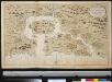
Porto de San Vincente aen de kust van Brazilia leggende op 24 graade breete int grood bestek
Brazil Gerard van Keulen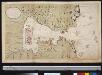
De Rio de Janeiro geleegen in Brazilia op 23 gr. Zd. breete vertoonende de stad en haven Janeiro als meede de stad St. Sebastiaen dewelke door 16 France oorlog scheepen onder Mons.r du Gue de Trouin den 12 september 1711 met de 3 forten sijn ingenoomen en geplundert
Brazil Gerard van Keulen
A new and most correct chart of the Entrance and Harbour of Rio de Janeiro
A new and most correct chart of the Entrance and Harbour of Rio de Janeiro. [With coast views.] From a survey made by order of the Portuguese Government. [Admiralty Chart] London : W. Faden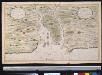
De haven van Spiritus Sanctus aen de kusten van Brazilia op 20 gr. 5 min. zuijder breeten
Brazil Gerard van Keulen
Planta geral da capital de Sao Paulo
1 : 20000 Sao Paulo (Brazílie) Cardim, Gomes W. Steidel