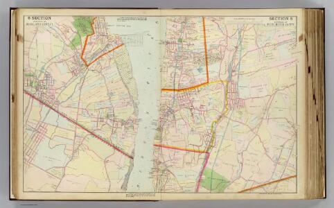
Maps of Town of Greenburgh
6 Rockland, Westchester counties.
1 : 14400 Watson & Co. (New York, N.Y.)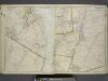
Portion of Rockland County. ; Portion of Westchester County.
from Atlas of the Hudson River Valley from New York city to Troy, including a section of about 8 miles in width. Published by Watson & co. Compiled from official records and careful surveys, under the supervision of F. W. Beers.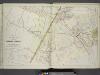
Plans of Parts of Piermont, Sparkill, and Palisades, N.Y. and Harrington, N.J.
from Atlas of the Hudson River Valley from New York city to Troy, including a section of about 8 miles in width. Published by Watson & co. Compiled from official records and careful surveys, under the supervision of F. W. Beers.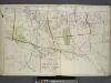
Plan of Irvington, Dobbs Ferry and Surroundings.
from Atlas of the Hudson River Valley from New York city to Troy, including a section of about 8 miles in width. Published by Watson & co. Compiled from official records and careful surveys, under the supervision of F. W. Beers.
Westchester, Double Page Plate No. 21 [Map of village of Hastings, Village of Dobbs Ferry, Village of Irvington] / prepared under the direction of Joseph R. Bien, from general surveys and official records.
From Atlas of Westchester County, New York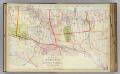
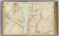
E3 Irvington, Dobbs Ferry.
1 : 9600 Watson & Co. (New York, N.Y.)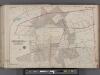
Bergen County, V. 1, Double Page Plate No. 27 [Parts of the boroughs of Harrington Park, Norwood TWP. of Harrington] / by George W. and Walter S. Bromley.
From V. 1, 1912.
Plates 34 & 35: Dobbs Ferry, Hastings upon Hudson, and Irvington.
from County atlas of Westchester, New York. Published by J.B. Beers & Co., assisted by S.W. Wilson and others.
Bergen County, V. 1, Double Page Plate No. 28 [Map of borough of Old Tappan] / by George W. and Walter S. Bromley.
From V. 1, 1912.
Hastings upon Hudson, Irvington.
from County atlas of Westchester, New York. Published by J.B. Beers & Co., assisted by S.W. Wilson and others.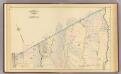
Yonkers wards 3-4.
1 : 9600 Bromley, George Washington; Bromley, Walter Scott; G.W. Bromley & Co.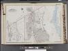
Westchester, V. 2, Double Page Plate No. 5 [Map bounded by Town of Green Hurgh, Grassy Sprain Rd., Sherman Ave., Odell Ave., Hudson River]
From Vol. 2
15. Yonkers.
1 : 3600 Kiser, Ellis; Mueller, A. H.
14. Yonkers.
1 : 2400 Kiser, Ellis; Mueller, A. H.
126-127 Greenburgh.
1 : 7200 G.W. Bromley & Co.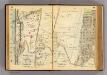
54-55 Yonkers.
1 : 7200 G.W. Bromley & Co.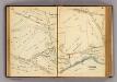
60-61 Yonkers.
1 : 7200 G.W. Bromley & Co.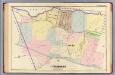
24. Yonkers.
1 : 3600 Kiser, Ellis; Mueller, A. H.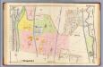
13. Yonkers.
1 : 2400 Kiser, Ellis; Mueller, A. H.
4. Yonkers-Tarrytown-Hartsdale.
1 : 80000 Servoss, R. D.
4. Yonkers-Tarrytown-Hartsdale.
1 : 80000 Servoss, R. D.
Plate 30: Town of Greenburgh, Westchester Co. N.Y.
from Atlas of New York and vicinity : from actual surveys / by and under the direction of F. W. Beers, assisted by A. B. Prindle & others
Westchester, Double Page Plate No. 20 [Map of town of Greenburg] / prepared under the direction of Joseph R. Bien, from general surveys and official records.
From Atlas of Westchester County, New York
Map of upper New York City and adjacent country showing the city above 125th Street. The City of Yonkers and Townships of East Chester, Westchester, Pelham, New Rochelle. . . Mamaroneck. Made by actual surveys under the direction of R. W. Burrowes, C....
From Bronx
Town of Greenburgh, Westchester County, New York.
1 : 42240 Beers, Frederick W.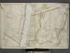
Portion of Bergen County, N.J.; Portion of City of Yonkers. And Westchester County
from Atlas of the Hudson River Valley from New York city to Troy, including a section of about 8 miles in width. Published by Watson & co. Compiled from official records and careful surveys, under the supervision of F. W. Beers.
Nyack
1 : 24000
Nyack
1 : 24000
Nyack
1 : 24000
Nyack
1 : 24000
Nyack
1 : 24000
Nyack
1 : 31680
Nyack
1 : 31680
Nyack
1 : 31680
Nyack
1 : 24000