Maps of Honshu

Japan.
1 : 4000000 Colton, G.W.
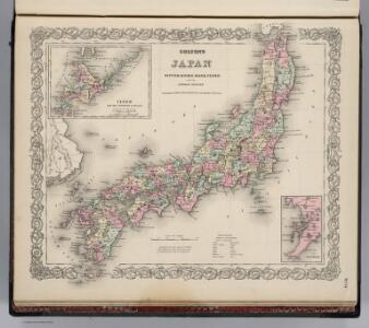
Japan. Nippon, Kiusiu, Sikok, Yesso and the Japanese Kuriles.
1 : 4000000 Colton, G.W.
Japan Nippon, Kiusiu, Sikok, Yesso And The Japanese Kuriles.
1 : 3928320 Colton, G.W.
Vegetationsgebiete der Japanischen Inseln
1 : 3000000 Fesca, Max [s.n.]
Japan. Nippon, Kiusiu, Sikok, Yesso and the Japanese Kuriles.
1 : 4000000 Colton, G.W.
Japan.
1 : 5000000 Andree, Richard; Times (London, England)
Japan.
1 : 4023000 Johnson, A.J.
Japan.
1 : 4000000 Colton, G.W.
101-02. Giappone.
1 : 3000000 Touring club italiano
Charte von Japan mit seinen 7 Provinzen
Japonsko Robert de Vaugondy, Didier
Charte von JAPAN mit seinen VII Provinzen
Japonsko Robert de Vaugondy, Gilles
Charte von Japan mit seinen VII Provinzen
Japonsko Visscher, Nicolaes Jansz. Robert de Vaugondy, Gilles
Empire of Japan.
1 : 4100000 Bowen, Emanuel
Nieuwe en naukeurige kaart van het keizerryk Japan, ontworpen niet alleen uit de aantekeningen der Portugeesen en Neederlanders, maar voornaamlijk der Jesuietsche zendelingen
1 : 4333000 eerst uitg. door den Heer Bellin te Parijs, en met sterrekundige waarnemingen vergeleken door Eman. Bowen nu in 't Nederduits voor 't licht gebragt [...] vermeerderd en verb. door W.A. Bachiene ; J. v. Jagen sculp. [Amsterdam] : [Matthijs Schalekamp]
Karte vom Japanischen Reiche
Japonsko Siebold, Philipp Franz Bayly, Alfred
Japan
1 : 5000000 Arrowsmith, Aaron; Lewis, Samuel
Japan.
1 : 5000000 Arrowsmith, Aaron; Lewis, Samuel
Japan
1 : 6000000 Arrowsmith, Aaron Jr.
The Empire of Japan divided into seven principal parts and subdivided into sixty six kingdoms : with the Kingdom of Corea, from Kempfer and the Portuguese
Annotatie: Uit: General atlas. - London : Robert Sayer, 1790; Lit.: Japan mit den Augen des Westens gesehen / hrsg. von Lutz Walter, p. 198; Tooley's dictionary of mapmakers, 1979, p. 380 London : Laurie & Whittle
L'Empire du Japon.
1 : 3000000 Robert de Vaugondy, Gilles, 1688-1766
Japan. Nippon, Kiusiu, Sikok, Yesso and the Japanese Kuriles.
1 : 4000000 Colton, G.W.
Iaponiae Insulae Descriptio. [Karte], in: Theatrum orbis terrarum, S. 396.
1 Karte aus Atlas Ortelius, Abraham Vrients, Jan Baptista
Carte des missions catholiques au Japon
1 : 2200000 Launay, Adrien 1853-1927 [Lyon : Oeuvre de la propagation de la foi]
Iaponia Regnum. [Karte], in: Novus atlas absolutissimus, Bd. 11, S. 238.
1 Karte aus Atlas Janssonius Offizin
Karte von Japan & Corea
1 : 6000000 Japonsko Hendel, Otto Otto Hendel
Japan, Korea.
1 : 3000000 Robert Laurie & James Whittle
Japan.
1 : 4752000 Letts, Son & Co.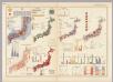
Japan. Pergamon World Atlas.
Polish Army Topography Service
天下輿地圖:日本圖
天下輿地圖 明清时期 该图集为李氏朝鲜时期舆图,前有《天下圖》和《中國圖》各一幅,后为朝鲜八道图及日本图。封面题有“玄黓執徐腊下瀚”,可能是壬辰年十二月下旬,但具体年份待定。内容与形态基本与上图相同(005833853),《天下圖》反映中国传统天下观,中国居中,周围岛国取自《山海经》,《中國圖》绘制明朝两京十三省。 1图,彩绘,中文,图幅27.8 x 34.3 cm。 Harvard-Yenching | Rare Book | TK 3490.7 1174;Hollis Number:009140732