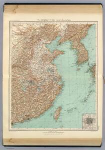
Maps of North China Plain

99-100. Cina Propria, Corea.
1 : 5000000 Touring club italiano
China.
1 : 13000000 Darton, William
China.
1 : 7500000 Lizars, Daniel
China.
1 : 13305600 Lucas, Fielding Jr.
Carte Particuliere de la Chine.
1 : 10000000 Vivien de St Martin, L.
China.
1 : 13000000 Tanner, Henry S.
China.
1 : 13400000 Finley, Anthony
China.
1 : 5702400 Stanford, Edward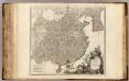
La Chine.
1 : 6000000 Robert de Vaugondy, Gilles, 1688-1766
China (Ostl. Theil), Korea Und Japan.
1 : 7500000 Petermann, A.
China and Japan.
1 : 6198300 Johnston, Alexander Keith
China (Östl. Theil), Korea und Japan
Hand-Atlas über alle Theile der Erde und über das Weltgebäude Stieler, Adolf Justus Perthes
China.
1 : 13300000 Finley, Anthony
China.
1 : 10500000 Mitchell, Samuel Augustus
China.
1 : 12800000 Lucas, Fielding Jr.
China, Japan.
1 : 6198319 Johnston, Alexander Keith, 1804-1871
China.
1 : 6150000 Cary, John, ca. 1754-1835
China.
1 : 10600000 Tanner, Henry S.
China.
1 : 10060000 Tanner, Henry S.
China.
1 : 5700000 Arrowsmith, John
China.
1 : 10000000 Colton, G.W.
Die Küste und die Inseln des Chienischen Reiches
1 : 6500000 Čína Müller, H. F.
China.
1 : 6600000 Hall, S. (Sidney)
China.
1 : 10500000 Tanner, Henry S.
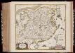
Pecheli, Xansi, Xantung, Honan, Nanking, In plaga Regni Sinensis inter Septentrionem ac Orientem Ceciam versus sitae Provinciae. [Karte], in: Novus atlas absolutissimus, Bd. 6, S. 127.
1 Karte aus Atlas Janssonius Offizin
[Ost-China, Korea und Japan]
Adolf Stieler's Handatlas über alle Theile der Erde und über das Weltgebäude Stieler, Adolf Justus Perthes
China (Östl. Theil), Korea und Japan
Handatlas über alle Theile der Erde und über das Weltgebäude Stieler, Adolf Justus Perthes
China.
1 : 10400000 Mitchell, Samuel Augustus
China.
1 : 10400000 Mitchell, Samuel Augustus