Maps of Italy
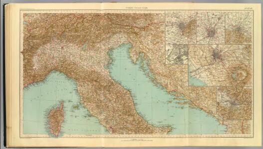
24-26. Italia nord.
1 : 1500000 Touring club italiano
Italia superior, Rhaetia, Noricum, Pannonia, Daciae et Illyrici partes occidentales
1 : 1880000 Dácie Reichard, Christian Gottlieb Campius, D. a D. Campio
Northern Italy, Austria, &c.
1 : 2000000 John Bartholomew and Son
Illyricum Occidentis
1 : 3000000 Mollova mapová sbírka Sanson, Nicolas Covens, Johannes I
Illyrivcum Occidentis
1 : 1300000 Mollova mapová sbírka Sanson, Nicolas Cordier, Louis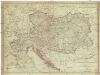
Karte der oesterreichischen Monarchie und der vor osterreichischen Prinzen und Prinzessinen beherrschten italienischen Staaten als Toscana, Modena, Parma und Massa nach dem Wiener Congresse den späteren Verträgen und Gränzbestimmungen
1 : 2000000 Evropa jihovýchodní Fried, Franz Reißer, Franz Artaria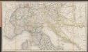
[Post und Reisekarte von Italien und den nördlich angrenzenden Alpenländern]
1 : 1800000 Roost, Johann Baptist J.G. Cotta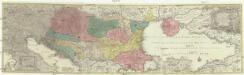
Tabula synoptica totius fluminis Danubii a fontibus usque ad ostia
1 : 2000000 Besarábie (Moldavsko a Ukrajina) Lotter, Tobias Conrad Tobias Conrad Lotter
Die Alpen
Plastischer Schul-Atlas über alle Theile der Erde : in 24 Karten Woldermann, G Verlag von P. Eckerlein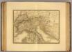
Italie, Suisse, Illyrie nord.
1 : 2100000 Picquet, C.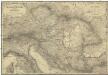
Oestreichs Laender unter den Roemern
1 : 2000000 Evropa jihovýchodní Renner, Emanuel von David, Johann J. G. Heubner
Oestreichs Laender unter den Roemern
1 : 2000000 Evropa jihovýchodní Renner, Emanuel von David, Johann J.G. Heubner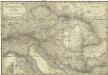
Oestreichs Laender unter den Roemern
1 : 2000000 Evropa jihovýchodní Renner, Emanuel von David, Johann J. G. Heubner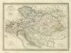
Composite: Carte Generale l'Empire d'Autriche.
1 : 2700000 Vivien de St Martin, L.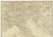
Italien
Itálie severní
Versuch einer Sprachenkarte der Österreichischen Monarchie
1 : 3000000 von J.V. Haeufler Pest : Emich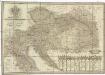
Neueste General- Post- und Strassen Karte der OEsterreichischen Monarchie
1 : 1500000 Evropa jihovýchodní Traux, Maximilian de Fried, Franz Artaria
Neueste General- Post- und Strassen Karte der OEsterreichischen Monarchie
1 : 1500000 Evropa jihovýchodní Traux, Maximilian de Fried, Franz Artaria & Compag.ie
Italia
1 : 1140000 Sacchi, Ferd. Ditta Artaria di Ferd.o Sacchi e figli
Im Aeroplan von der Adria zu den Alpen
Pohraničí rakousko-uhersko-italské
1 : 1250000 Itálie Machát, František V. Neubert
Carte Generale de L'Italie.
1 : 2800000 Vivien de St Martin, L.
Politische Übersicht von Süd-Deutschland und Oesterreich
E. von Sydow's Schul-Atlas in sechs und dreissig Karten Sydow, Emil von bei Justus Perthes
Historisch-geographisch-statistische Karte vom Kaiserthum Oesterreich
Evropa jihovýchodní Bastien, J. Schnabel, Jiří Norbert G.N. Schnabel
Carta postale ed itineraria dell'Italia
Itálie Botte, A. F. Deyé A.F. Botte
Carta postale ed itineraria dell' Italia
Chorvatsko Botte, A.F.
Exactissima Tabula, qua tam Danubii Fluvii Pars Superior
1 : 2100000 Mollova mapová sbírka Visscher, Nicolaes Jansz. Visscher, Nicolaus
Exactissima Tabula, qua tam Danubii Fluvii Pars Superior
1 : 2100000 Mollova mapová sbírka Visscher, Nicolaes Jansz. Visscher, Nicolaus
Carta postale e stradale dell'Italia
1 : 1050000 Itálie Pinneti, G. A. F. Artaria
Danubii fluminis (à fontibus prope Doneschingam usq[ue] Posonium urbem designati) pars superior
1 Karte : Kupferdruck ; 46 x 54 cm Homann Johann Baptist Homann