Maps of Missouri
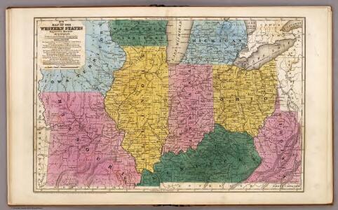
Map of the Western States.
1 : 3200000 Mitchell, Samuel Augustus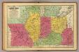
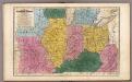
Western States.
1 : 3200000 Mitchell, Samuel Augustus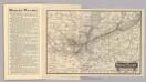
Map Wabash Railway.
1 : 6623200 Wabash Railway Company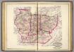
Ind., Ill., Mo., Ohio, Ky, Tenn.
1 : 2100000 Asher, Adams & Higgins; Higgins & Ryan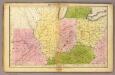
Western States.
1 : 3000000 Huntington, Francis Junius, 1802-1878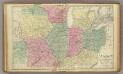
Western U.S.
1 : 3000000 Cornell, S. S. (Sarah S.)
Guide through Ohio, Michigan, Indiana, Illinois, Missouri, Wisconsin & Iowa : showing the township lines of the United States Surveys, location of cities, towns, villages, post hamlets, canals, rail and stage roads / by J. Calvin Smith ; engr. by S. Stiles, Sherman & Smith
1 : 2200000 Annotatie: Gerestaureerd en op Japans papier geplakt; Met statistische gegevens m.b.t. bevolking, landbouw en veeteelt, industrie en openbare financiën J. Calvin Smith; S. Stiles, Sherman & Smith New York, [N.Y.] : J.H. Colton & Co.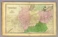
Western States.
1 : 3000000 Olney, J. (Jesse), 1798-1872
Western States.
1 : 6400000 Adams, Daniel
Western States, United States.
Goodrich, S.G.
Western states, territories.
1 : 6400000 Grigg, John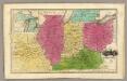
Western States. (with) inset map of Upper Michigan.
1 : 3000000 Smiley, Thomas T.
Map of the Back Settlements.
1 : 6336000 Morse, Jedidiah
151. Centers farm, agricultural products, population, manufactures.
1 : 7000000 Gannett, Henry, 1846-1914; United States. Census Office
126. Centers of population, farms, agricultural products, manufactures 1790-1900.
1 : 7000000 Gannett, Henry, 1846-1914; United States. Census Office
Ohio, Indiana, Illinois, Michigan.
1 : 2063000 Finley, Anthony
Western States.
1 : 4200000 Huntington, Nathaniel G. (Nathaniel Gilbert), 1785-1848
The Western Parts of Virginia, Pennsylvania, Maryland and North Carolina.
1 : 1140480 Hutchins, Thomas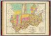
Map of the States Of Ohio Indiana & Illinois And Part Of Michigan Territory.
1 : 2000000 Finley, Anthony
Maps showing the Indiana & Illinois Central Railway.
1 : 1267200 G.W. & C.B. Colton & Co.
Ohio, Indiana, Kentucky, and Tennessee.
1 : 3651000 Fisher, Richard Swainson
County map of Ohio and Indiana.
from New general atlas.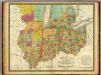
Ohio, Indiana & Illinois And Part Of Michigan Territory.
1 : 2060000 Mitchell, Samuel Augustus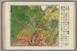
Soil Map of the United States, Section 7. Atlas of American Agriculture.
1 : 2500000 Marbut, Curtis F.
Map Pittsburgh & Western Railway Co.
1 : 5844000 Pittsburgh & Western Railway Company
County map of the States of Iowa and Missouri.
from Mitchell's new general atlas, containing maps of the various countries of the world, plans of cities, etc., embraced in fifty-three quarto maps., forming a series of eighty four maps and plans, together with valuable statistical tables.
Ohio, Indiana & Illinois.
1 : 2400000 Black, Adam & Charles
General Map of the Course of the Ohio.
1 : 563200 Tardieu, P.F.
Illinois And Missouri.
1 : 1140480 Tanner, Henry S.