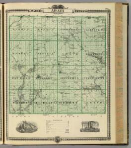
Maps of Adair County

Map of Adair County, State of Iowa.
1 : 126720 Andreas, A. T. (Alfred Theodore), 1839-1900
Greenfield
1 : 62500
Arbor Hill
1 : 24000
Fontanelle
1 : 24000
Rosserdale
1 : 24000
Stuart South
1 : 24000
Canby
1 : 24000
Canby
1 : 24000
Zion
1 : 24000
Orient
1 : 24000
Nevinville
1 : 24000
Fontanelle SW
1 : 24000
Adair South
1 : 24000
Creston
1 : 100000
Bridgewater
1 : 24000
Omaha
1 : 250000
Omaha
1 : 250000
Omaha
1 : 250000
Omaha
1 : 250000
Omaha
1 : 250000
Menlo
1 : 24000
Stuart North
1 : 24000
Casey
1 : 24000
Pitzer
1 : 24000
Earlham West
1 : 24000
Macksburg
1 : 24000
Panora
1 : 62500
Winterset
1 : 62500
Adair North
1 : 24000