Maps of Connecticut

A map of the Province of New York, with part of Pensilvania, and New England.
from Charts and maps
Pensylvania Nova Jersey et Nova York cum regionibus ad fluvium Delaware in America sitis, nova delineatione ob oculos posita
1 : 2200000 New Jersey Lotter, Tobias Conrad per Tob. Conr. Lotter
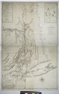
Map of Hudson's River, with the adjacent country.
from Hudson River for D. Henry: [London],
Map of the state of New York / by Simeon De Witt, surveyor general ; engraved by G. Fairman.
from Whole
A chorographical map of the Province of New-York in North America, divided into counties, manors, patents and townships, exhibiting likewise all the private grants of land made and located in that Province
1 : 322000 Sauthier, Claude Joseph Faden, William
New York (eastern section).
1 : 570000 Rand McNally and Company
Carte de la route des lacs depuis Montréal et St. Jean jusqu'à la Riviere d'Hudson réduite d'après les meilleures cartes anglais e[s], pour servir aux Essais historiques et politiques sur la révolution de l'Amérique septentrionale
1 : 475200 Hilliard d'Auberteuil, Michel René
Map of the New York & Boston Railway : with its connections with other railways
Swett and Powers (Firm) Swett & Powers
North America 1:1,000,000
1 : 1000000 Hudson (New York a New Jersey : řeka : oblast) United States Geological survey
Patroonships, manors and seigniories in New York recognized by the Order of Colonial Lords of Manors / Max Mayer, Thornwood, N.Y.
Max Mayer, Thornwood,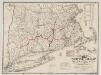
The "centennial" postal statistical map of Massachusetts, Rhode Island and Connecticut : showing railroads, post routes and offices together with population and valuation of cities and towns
1 : 422400 Cook and Ellis (Firm) M.G. Cook and Frank O. Ellis
A new and accurate map of the province of New York and part of the Jerseys, New England and Canada, shewing the scenes of our military operations during the present war, also the new erected state of Vermont

Map of the state of New York / by Simeon De Witt, surveyor general; engraved by G. Fairman.
from Charts and maps Simeon De Witt; G. Fairman,
New England and New York in 1697

Massachusetts. Atlas Plate No. 14.
1 : 63360 Walker, O.W.
[Kaart], uit: Travellers' guide of the Hudson River
1 : 650000 Annotatie: Met beknopte beschrijving van de belangrijkste aan de Hudson gelegen plaatsen [S.l. : H.B. Kirkham]
Part of New England, New York, east New Iarsey and Long Iland.
from Parts
Various Regions and Cities in New England.
Shell Oil Company
Railroad Map Featuring Many Northeastern States Rhode Island Connecticut Massachusetts
1 : 2000
Putman, Rockland, Westchester, New York, Richmond, Kings, Queens, and Suffolk Counties
from New topographical atlas and gazetteer of New York, comprising a topographical view of the several counties of the state, ... including ... map of the United States and territories ... Compiled from the latest astronomical observations, official surveys and records of the United States and territories ...
"Delaware, Sullivan, Greene, Ulster, Orange, Columbia, Dutchess, and Putman Counties"
from New topographical atlas and gazetteer of New York, comprising a topographical view of the several counties of the state, ... including ... map of the United States and territories ... Compiled from the latest astronomical observations, official surveys and records of the United States and territories ...
A map of the most inhabited part of New England containing the provinces of Massachusets Bay and New Hampshire with the colonies of Connecticut and Rhode Island divided into counties and townships the w[h]ole composed from actual surveys ...

A map of the most inhabited part of New England, containing the provinces of Massachusets Bay and New Hampshire, with the colonies of Connecticut and Rhode Island, divided into counties and townships, the whole composed from actual surveys ...

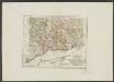
Connecticut, from the best authorities.
from Carey's general atlas, improved and enlarged : being a collection of maps of the world and quarters, their principal empires, kingdoms, &c.
Connecticut and parts adjacent
1 : 375000 Covens et Mortier et Covens, junior
Province de New-York: en 4 feuilles / par Montrésor.
from (A-Z) John Montrésor,
Province de New-York: en 4 feuilles / par Montrésor.
from (A-Z) John Montrésor,
County map of Massachusetts, Connecticut, and Rhode Island.
from New general atlas.
New York.
1 : 614000 Hammond, C.S.