Maps of Clifton
City of Paterson. Part of the 3rd Ward
from Atlas of Passaic County, New-Jersey : topographical, geological, historical, illustrated ; from actual surveys of each township and village / under the supervision of the publishers, assisted by the able engineers of Paterson.
City of Paterson. Part of the 3rd Ward
from Atlas of Passaic County, New-Jersey : topographical, geological, historical, illustrated ; from actual surveys of each township and village / under the supervision of the publishers, assisted by the able engineers of Paterson.
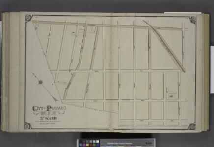
City of Paterson. Part of the 3rd Ward
from Atlas of Passaic County, New-Jersey : topographical, geological, historical, illustrated ; from actual surveys of each township and village / under the supervision of the publishers, assisted by the able engineers of Paterson.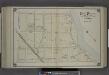
City of Paterson. Part of the 3rd Ward
from Atlas of Passaic County, New-Jersey : topographical, geological, historical, illustrated ; from actual surveys of each township and village / under the supervision of the publishers, assisted by the able engineers of Paterson.
Outline Map of Passaic City in Acquackanonck TWP, N.J.
from Atlas of Passaic County, New-Jersey : topographical, geological, historical, illustrated ; from actual surveys of each township and village / under the supervision of the publishers, assisted by the able engineers of Paterson.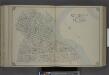
City of Paterson. Part of the 1st and 2nd Wards
from Atlas of Passaic County, New-Jersey : topographical, geological, historical, illustrated ; from actual surveys of each township and village / under the supervision of the publishers, assisted by the able engineers of Paterson.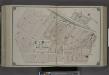
City of Paterson. Part of the 1st and 2nd Wards
from Atlas of Passaic County, New-Jersey : topographical, geological, historical, illustrated ; from actual surveys of each township and village / under the supervision of the publishers, assisted by the able engineers of Paterson.
Orange
1 : 24000
Orange
1 : 24000
Orange
1 : 24000
Orange
1 : 24000
Orange
1 : 24000
Orange
1 : 24000
Newark-Paterson.
1 : 31680 Vermeule, C. C. (Cornelius Clarkson), 1858-1950
Paterson
1 : 62500
Paterson
1 : 62500
Paterson
1 : 62500
Paterson
1 : 62500
Paterson
1 : 62500
Paterson
1 : 62500
Paterson
1 : 62500
Paterson
1 : 62500
Paterson
1 : 62500
Paterson
1 : 62500
Paterson
1 : 62500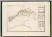
Canal Morris.
1 : 250000 Poussin, Guillaume Tell, 1794-1876
Facsimile of the unpublished British head quarters coloured manuscript map of New York & environs / reproduced from the original drawing in the War Office, London.
from Whole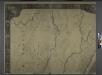
General map of the city of New York, consisting of boroughs of Manhattan, Brooklyn, Bronx, Queens and Richmond : consolidated into one municipality by act of the legislature of the state of New York (Chapter 378 of the laws of 1897) : showing in addition
from Whole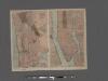
TheHome Life Publishing Co.' s map of the City of New York.
From Manhattan