Maps of Passaic
City of Paterson. Part of the 1st Ward
from Atlas of Passaic County, New-Jersey : topographical, geological, historical, illustrated ; from actual surveys of each township and village / under the supervision of the publishers, assisted by the able engineers of Paterson.
City of Paterson. Part of the 1st and 2nd Wards
from Atlas of Passaic County, New-Jersey : topographical, geological, historical, illustrated ; from actual surveys of each township and village / under the supervision of the publishers, assisted by the able engineers of Paterson.
City of Paterson. Part of the 1st and 2nd Wards
from Atlas of Passaic County, New-Jersey : topographical, geological, historical, illustrated ; from actual surveys of each township and village / under the supervision of the publishers, assisted by the able engineers of Paterson.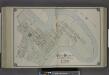
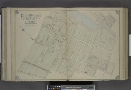
City of Paterson. Part of the 1st Ward
from Atlas of Passaic County, New-Jersey : topographical, geological, historical, illustrated ; from actual surveys of each township and village / under the supervision of the publishers, assisted by the able engineers of Paterson.
Outline Map of Passaic City in Acquackanonck TWP, N.J.
from Atlas of Passaic County, New-Jersey : topographical, geological, historical, illustrated ; from actual surveys of each township and village / under the supervision of the publishers, assisted by the able engineers of Paterson.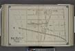
City of Paterson. Part of the 3rd Ward
from Atlas of Passaic County, New-Jersey : topographical, geological, historical, illustrated ; from actual surveys of each township and village / under the supervision of the publishers, assisted by the able engineers of Paterson.
Newark-Paterson.
1 : 31680 Vermeule, C. C. (Cornelius Clarkson), 1858-1950
Paterson
1 : 62500
Paterson
1 : 62500
Paterson
1 : 62500
Paterson
1 : 62500
Paterson
1 : 62500
Paterson
1 : 62500
Paterson
1 : 62500
Paterson
1 : 62500
Paterson
1 : 62500
Paterson
1 : 62500
Paterson
1 : 62500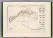
Canal Morris.
1 : 250000 Poussin, Guillaume Tell, 1794-1876
Facsimile of the unpublished British head quarters coloured manuscript map of New York & environs / reproduced from the original drawing in the War Office, London.
from Whole
General map of the city of New York, consisting of boroughs of Manhattan, Brooklyn, Bronx, Queens and Richmond : consolidated into one municipality by act of the legislature of the state of New York (Chapter 378 of the laws of 1897) : showing in addition
from Whole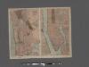
TheHome Life Publishing Co.' s map of the City of New York.
From Manhattan
Paterson, N.J. - N.Y., ed. of Feb. 1903, repr. 1924
from New Jersey, 15 minute series (topographic) / mapped, edited, and published by the Geological Survey.
Manhattan public and publicly aided housing
From The Borough
Map of part of New York City, showing underground mains of the Edison Electric Illuminating Co. of New York.
From Manhattan
Map of New York City showing portions of Brooklyn, Jersey City, and Westchester Co.
From Manhattan
Westchester, Double Page Plate No. 2 [Map of City and County of new York] / prepared under the direction of Joseph R. Bien, from general surveys and official records.
From Atlas of Westchester County, New York
Manhattan land use policy
From The Borough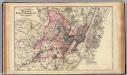
Hudson, Union, Essex Cos., N.J.
1 : 126720 Beers, F. W. (Frederick W.)