Maps of Egremont

Hillsdale [Township]
from Atlas of Columbia County, New York. From actual surveys and official records. Compiled & published by D. G. Beers & Co.
Hillsdale
1 : 24000
Hillsdale
1 : 24000
Hillsdale
1 : 24000
Hillsdale
1 : 24000
Egremont
1 : 25000
Egremont
1 : 24000
Egremont
1 : 24000
Egremont
1 : 25000
Egremont
1 : 25000
Egremont
1 : 24000
Egremont
1 : 24000
Egremont
1 : 25000
Egremont
1 : 31680
Egremont
1 : 24000
Egremont
1 : 31680
Ghent [Village]; Harlemville [Village]; Ghent Business Notices.; Harlemville Business Notices.; Green River [Village]; Green River Business Notices.; Hillsdale Business Notices.; Hillsdale [Village]
from Atlas of Columbia County, New York. From actual surveys and official records. Compiled & published by D. G. Beers & Co.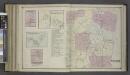
Charyville [Village]; Copake Station [Village]; Copake Flats [Village]; Gallatinville [Village]; Copake Business Notices.; Copake [Township]
from Atlas of Columbia County, New York. From actual surveys and official records. Compiled & published by D. G. Beers & Co.
Austerlitz [Township]
from Atlas of Columbia County, New York. From actual surveys and official records. Compiled & published by D. G. Beers & Co.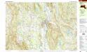
Great Barrington
1 : 25000
Great Barrington
1 : 25000
Chatham
1 : 24000
Chatham
1 : 24000
Chatham
1 : 24000
Chatham
1 : 24000
Chatham
1 : 24000
New York
1 : 2000000 Breese, S.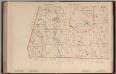
Massachusetts. Atlas Plate No. 27.
1 : 63360 Walker, O.W.
Sheffield quadrangle, Massachusetts
1 : 62500 Geological Survey (U.S.) U.S. Geological Survey
Copake
1 : 62500
Copake
1 : 62500
Copake
1 : 62500
Copake
1 : 62500
Copake
1 : 62500
Copake
1 : 62500
Copake
1 : 62500
![Hillsdale [Township]](https://images-1.georeferencer.com/images/iiif/961591529272/full/,300/0/native.jpg)

