Maps of Manhasset
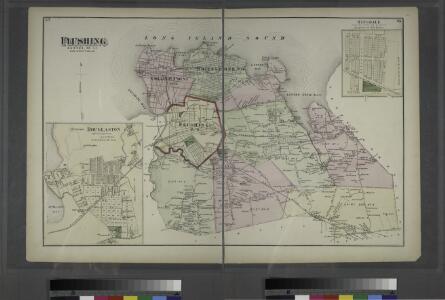
Flushing, Queens Co. L.I. - Douglaston, Town of Flushing, Queens Co. - Hinsdale, Town of Flushing, Kings Co.
from Atlas of Long Island, New York. From recent and actual surveys and records.
Plate 29: Town of Flushing. - Douglaston. - Bay Side.
from Atlas of Queens Co., Long Island, New York / compiled from official records, private plans & actual surveys by and under the direction of Chester Wolverton.
Map of Kings and part of Queens Counties, Long Island, N.Y. / [cartographic material]
From Counties
Key Continued
From Atlas 137. Vol. 3, 1902.
Map of Flushing published by the Flushing United Association. List of references to public buildings.
From Queens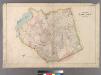
Plate 30: Town of Newtown.
from Atlas of Queens Co., Long Island, New York / compiled from official records, private plans & actual surveys by and under the direction of Chester Wolverton.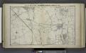
Great Neck Ests. - Manhasset - Roslyn - Mineola, Etc.
from Atlas of Nassau County, Long Island, N.Y. Complete in one volume. Historical, statistical. Based upon maps on file at the county seat in Mineola and upon private plans and surveys furnished by surveyors and individual owners. Supplemented by careful measurements & field observations by our own corps of engineers.
Key
From Atlas 137. Vol. 3, 1902.
Bayside, Auburndale, Oakland Gardens, Little Neck, Douglaston. (cont.)
From District 11
Flushing, College Point, Whitestone, Malba, Beechhurst, Bayside, Queensboro Hill, Willets Point. (cont.)
From District 7
Land use policy (cont.)
From District 11
Key Continued
From Atlas 141. Vol. 5, 1903.
Kew Gardens Hills, Utopia, Fresh Meadows, Hillcrest, Briarwood, Jamaica Hills. (cont.)
From District 8
Key
From Atlas 142a, Vol. 6, 1911.
Area District Map Section No. 11
From Area district map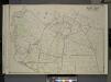
Queens, Vol. 3, Double Page Plate No. 19; Part of ward Three Flushing; [Map bounded by Strongs Causeway Ireland, Mill Road, North Hempstead Turnpike, Crop Road, Union Ave., Hoffman Ave., Boundary Line of Flushing, Jamaica, Head of the Vlei
from Third ward: Flushing.
Key Continued
From Atlas 148, Vol. 10, 1914.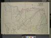
Queens, Vol. 2, Double Page Plate No. 28; Part of Ward Two Newtown, Corona, Hopedale and Richmond Hill; [Map bounded by Flushing Creek, Old Town of Jamaica and Newtown, Boundary Line between Jamaica and Newtown, Dry Harbor Road, Trotting
from First and second wards: Long Island City and Newtown.
Area District Map Section No. 10
from Area district map / City of New York, Board of Estimate and Apportionment.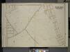
Queens, Vol. 3, Double Page Plate No. 15; Part of ward Three Whitestone; [Map bounded by 14th Ave., 11th Ave., Ave. A, Ave. B, Ave. C, Lane, Penn Ave., Willets Point Road, Whitestone Road, Fairview Ave., Plateau Ave., Bay View Ave.; Includ
from Third ward: Flushing.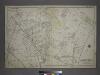
[Plate 18: Bounded by Remsen Street, North Hempstead Plank Road, Corona Avenue, Strongs Causeway, Douglass Street (Queensboro Hills), Ireland Hill Road, North Hempstead Turnpike, Renwick Avenue, Union Avenue, Metropolitan Avenue and Trotting Course.]
from Atlas of the city of New York, borough of Queens, Long Island City, Newtown, Flushing, Jamaica, Far Rockaway, from actual surveys and official plans / by George W. and Walter S. Bromley.
Queens, Vol. 2, Double Page Plate No. 30; Part of Ward Two Newtown, Trains Meadow, Wood Side and Elmhurst; [Map bounded by Bowery Bay, Flushing Bay, Corona, Junction Ave.; Including Elmhors Ave., Astoria and Flushing Turnpike, Woodside Ave., J
from First and second wards: Long Island City and Newtown.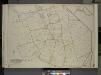
Queens, Vol. 3, Double Page Plate No. 20; Part of ward Three Sub Plan No. 1; [Map bounded by Broadway, Little Neck Road, West end Drive, Lakeville Road]; Part of ward Three Sub Plan No. 2; [Map bounded by Little Neck Bay]; Part of ward Thre
from Third ward: Flushing.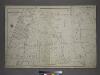
Part of the Borough of Queens, Flushing, Ward 3.
from Atlas of the city of New York, borough of Queens, Long Island City, Newtown, Flushing, Jamaica, Far Rockaway, from actual surveys and official plans / by George W. and Walter S. Bromley.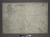
[Plate 30: Bounded by Nassau Road, Broadway, Clinton Avenue, East Alley Road, Little Neck Road, Jericho Turnpike, Rocky Hill Road, Alley Road and Broadway.]
from Atlas of the city of New York, borough of Queens, Long Island City, Newtown, Flushing, Jamaica, Far Rockaway, from actual surveys and official plans / by George W. and Walter S. Bromley.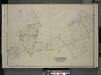
Queens, Vol. 3, Double Page Plate No. 4; Part of ward Three College Point. [Map bounded by 11th Ave., 10th Ave., 7th Ave., 6th Ave., Linden Ave., 5th Ave., Simths Lane, 4th Ave., Lawrence Ave., 3rd Ave., Nostrand Lane, Old Flushing Rd., Whitestone
from Third ward: Flushing.
Key
From Atlas 139. Vol. 4, 1901.
Key Continued
From Atlas 148, Vol. 10, 1914.
Key Continued
From Atlas 137a. Vol. 3, 1914.