Maps of Harghita

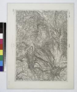
Szovata.
from Spezialkarte der osterreichisch-ungarischen Monarchie.
Szováta
1 : 75000 Judeţ Mureş
Lambert-Cholesky sheet 3867 (Lăzurele)
1 : 20000 Romanian military topographic map sheet under Lambert-Cholensky projection Direcția Topografică Militară geo-spatial.org Direcția Topografică Militară
Lambert-Cholesky sheet 3866 (Piatra Şoimului)
1 : 20000 Romanian military topographic map sheet under Lambert-Cholensky projection Direcția Topografică Militară geo-spatial.org Direcția Topografică Militară
Lambert-Cholesky sheet 3769 (Fâncelul de Jos)
1 : 20000 Romanian military topographic map sheet under Lambert-Cholensky projection Institutul Geografic al Armatei geo-spatial.org Institutul Geografic al Armatei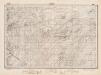
Lambert-Cholesky sheet 3768 (Sacadat)
1 : 20000 Romanian military topographic map sheet under Lambert-Cholensky projection Direcția Topografică Militară geo-spatial.org Direcția Topografică Militară
Lambert-Cholesky sheet 3767 (Sovata)
1 : 20000 Romanian military topographic map sheet under Lambert-Cholensky projection Direcția Topografică Militară geo-spatial.org Direcția Topografică Militară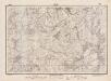
Lambert-Cholesky sheet 3766 (Corund)
1 : 20000 Romanian military topographic map sheet under Lambert-Cholensky projection Direcția Topografică Militară geo-spatial.org Direcția Topografică Militară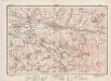
Lambert-Cholesky sheet 3669 (Hodac)
1 : 20000 Romanian military topographic map sheet under Lambert-Cholensky projection Institutul Geografic al Armatei geo-spatial.org Institutul Geografic al Armatei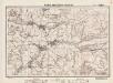
Lambert-Cholesky sheet 3668 (Eremitul)
1 : 20000 Romanian military topographic map sheet under Lambert-Cholensky projection Direcția Topografică Militară geo-spatial.org Direcția Topografică Militară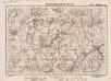
Lambert-Cholesky sheet 3667 (Măgherani)
1 : 20000 Romanian military topographic map sheet under Lambert-Cholensky projection Direcția Topografică Militară geo-spatial.org Direcția Topografică Militară
Lambert-Cholesky sheet 3666 (Ghindari)
1 : 20000 Romanian military topographic map sheet under Lambert-Cholensky projection Serviciul Geografic al Armatei geo-spatial.org Serviciul Geografic al Armatei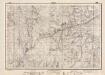
Lambert-Cholesky sheet 3868 (Tătarca)
1 : 20000 Romanian military topographic map sheet under Lambert-Cholensky projection Direcția Topografică Militară geo-spatial.org Direcția Topografică Militară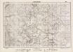
Lambert-Cholesky sheet 3869 (Poiana Draguşa)
1 : 20000 Romanian military topographic map sheet under Lambert-Cholensky projection Direcția Topografică Militară geo-spatial.org Direcția Topografică Militară
Gyergyo.
from Spezialkarte der osterreichisch-ungarischen Monarchie.
Szekely-Udvarhely.; Spezialkarte der osterreichisch-ungarischen Monarchie.
from Spezialkarte der osterreichisch-ungarischen Monarchie. Austro-Hungarian Monarchy. Militärgeographisches Institut.,
Székely Udvarhely
1 : 75000 Odorheiu Secuiesc
Lambert-Cholesky sheet 3569 (Reghin)
1 : 20000 Romanian military topographic map sheet under Lambert-Cholensky projection Institutul Geografic Militar geo-spatial.org Institutul Geografic Militar
Lambert-Cholesky sheet 3568 (Iara de Mureş)
1 : 20000 Romanian military topographic map sheet under Lambert-Cholensky projection Institutul Geografic Militar geo-spatial.org Institutul Geografic Militar
Lambert-Cholesky sheet 3567 (Moşuni)
1 : 20000 Romanian military topographic map sheet under Lambert-Cholensky projection Direcția Topografică Militară geo-spatial.org Direcția Topografică Militară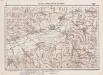
Lambert-Cholesky sheet 3566 (Troiţa)
1 : 20000 Romanian military topographic map sheet under Lambert-Cholensky projection Serviciul Geografic al Armatei geo-spatial.org Serviciul Geografic al Armatei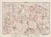
Lambert-Cholesky sheet 3765 (Medişor)
1 : 20000 Romanian military topographic map sheet under Lambert-Cholensky projection Direcția Topografică Militară geo-spatial.org Direcția Topografică Militară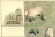
Plan des Bergwergs Weres Patack
Mollova mapová sbírka Geyer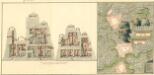
Plan deren Bergwerg Nagiay: i Offi und Bedas
Mollova mapová sbírka Geyer
Siebenbürgen
1 : 600000 Siebenbürgen
Ost-Karpathen
1 : 600000 Karpaten (Südost)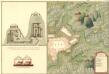
Plan des Bergwergs Igen.
Mollova mapová sbírka Geyer
Maros-Vasarhely.
from Spezialkarte der osterreichisch-ungarischen Monarchie.
Görgényszentimre
1 : 75000 Judeţ Mureş