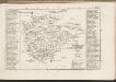
Maps of Lenti járás

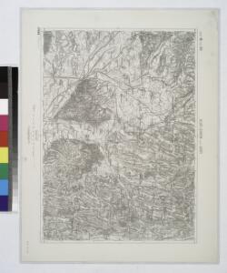
Also-Lendva und Lenti.
from Spezialkarte der osterreichisch-ungarischen Monarchie.
Alsó Lendva
1 : 75000 Lendava, Lendava (Region)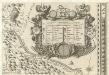
Stÿriae Ducatus Fertilisimi Nova Geographica Descriptio
1 : 200000 Mollova mapová sbírka Vischer, Georg Matthaeus Trost, Andreas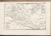
C. Szaladiensis. Tab. I
Ungarn Komitat Zala
Štajnamanger
1 : 200000 Szombathely (Maďarsko) Kartografska radionica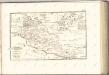
Eisemburger Com. Tab. II
Ungarn Komitat Vas
Warasdin und Kotor.; Spezialkarte der osterreichisch-ungarischen Monarchie.
from Spezialkarte der osterreichisch-ungarischen Monarchie. Austro-Hungarian Monarchy. Militärgeographisches Institut.,
Warasdin
1 : 75000 Varaždin, Varaždin (Region)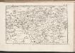
C. Szaladiensis. Tab. II
Ungarn Komitat Zala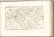

Mappa Comitatvs Soproniensis 1758
1 : 1250000 Mollova mapová sbírka Zeller, Sebastian
Specialkarte zu den Manövern des 3. Corps 1891
1 : 75000 K.u.k militär-geographisches Institut
Generalkarte zu den Manövern des 3. Corps 1891
1 : 300000 Lublaň (Slovinsko : oblast)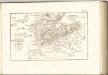

Comitatus Castri Ferrei
1 : 110000 Maďarsko Kenedics, Joseph Mansfeld, Johann Ernst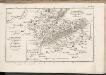
C. Szaladiensis. Tab. III
Ungarn Komitat Zala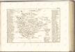

Szalader com[it.] Schackmin Cvrassie Regiments
1 : 467000 Balaton-oblast (Maďarsko) Cir, V.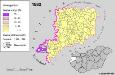
A szlovének arány és száma Vas megyében 1880-ban
Komitat Vas Slowenen, Siedlung Bottlik, Zsolt
Radkersburg und Luttenberg.
from Spezialkarte der osterreichisch-ungarischen Monarchie.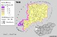
Slowenen im Komitat Vas 1880
Komitat Vas Slowenen, Siedlung Bottlik, Zsolt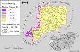
Slowenen im Komitat Vas 1941
Komitat Vas Slowenen, Siedlung Bottlik, Zsolt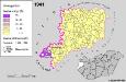
A szlovének arány és száma Vas megyében 1941-ben
Komitat Vas Slowenen, Siedlung Bottlik, Zsolt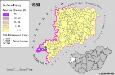
Slowenen im Komitat Vas 1980
Komitat Vas Slowenen, Siedlung Bottlik, Zsolt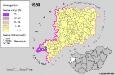
A szlovének arány és száma Vas megyében 1980-ban
Komitat Vas Slowenen, Siedlung Bottlik, Zsolt
Kis-Komarom und Zala-Szt.-Mihaly.
from Spezialkarte der osterreichisch-ungarischen Monarchie.
Nagycsákány
1 : 75000 Komitat Komárom-Esztergom
Czakany und Zala-Lovo (Ungarn).; Spezialkarte der osterreichisch-ungarischen Monarchie.
from Spezialkarte der osterreichisch-ungarischen Monarchie. Austro-Hungarian Monarchy. Militärgeographisches Institut.,