Maps of Teplá

Tepl und Tuschkau.
from Spezialkarte der osterreichisch-ungarischen Monarchie.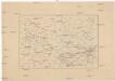
[Okolí Plzně - západ]
Plzeň-oblast (Česko) Krejčí, Jan Schwarzenberg, Bedřich
Generalkarte der Bezirkshauptmannschaft Mies
1 : 220000 Stříbro-oblast (Česko) Wagner, Jan Eduard F. Kytka
Teplá
1 : 75000 Bezdružice (Česko : oblast) Vojenský zeměpisný ústav
Tepl und Tuschkau
1 : 75000 Město Touškov (Česko : oblast) Bloschitz, Rudolf K. u. k. Militärgeographisches Institut
Tepl und Tuschkau
1 : 75000 Město Touškov-oblast (Česko) K. u. k. Militärgeographisches Institut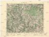
Město Teplá
1 : 75000 Teplá (Cheb, Česko : oblast) Vojenský zeměpisný ústav
Město Teplá
1 : 75000 Teplá-oblast (Cheb, Česko) Vojenský zeměpisný ústav
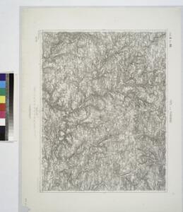
III. vojenské mapování 4050
1 : 75000
Stříbro a okolí
1 : 75000 Stříbro (Česko : oblast) Vojenský zeměpisný ústav

Podrobná mapa Království českého
1 : 100000 Planá (Tachov, Česko : oblast) Srp, Jan Jaroslav Bursík
Vilímkovy místopisné mapy zemí Koruny české
1 : 100000 Chodová Planá (Česko : oblast) Srp, Jan Jos. R. Vilímek
Mieser Vicariat
Stříbro-oblast (Česko)

Povodeň ve středních Čechách dne 25. a 26. května 1872


III. vojenské mapování 4050/1
1 : 25000
III. vojenské mapování 4050/3
1 : 25000
[Kartenblatt]
1 : 25000 Bezdružice (Česko : oblast) Reichsamt für Landesaufnahme
Gradkartenblatt
1 : 25000 Město Touškov-oblast (Česko) Brzesina, Julius von
Gradkartenblatt
1 : 25000 Teplá-oblast (Cheb, Česko) Böhm, Karl
Gradkartenblatt
1 : 25000 Manětín-oblast (Česko) Brzesina, Julius von
Gradkartenblatt
1 : 25000 Stříbro-oblast (Česko) Bulla, Eduard
III. vojenské mapování 4050/4
1 : 25000
[Kartenblatt]
1 : 25000 Dolní Bělá (Česko : oblast) Reichsamt für Landesaufnahme
III. vojenské mapování 4050/2
1 : 25000
[Kartenblatt]
1 : 25000 Město Touškov (Česko : oblast) Reichsamt für Landesaufnahme
[Kartenblatt]
1 : 25000 Stříbro (Česko : oblast) Reichsamt für Landesaufnahme