Maps of okres Bruntál

Jacerndorf.
from Spezialkarte der osterreichisch-ungarischen Monarchie.
Reymann ́s Special Karte 190 Troppau

Krnovsko a Osoblažsko

Karte des politischen Bezirkes Freudenthal

Jägerndorf
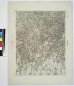
1 : 75000 Krnov (Česko : oblast) Schuberth K. u. k. Militärgeographisches Institut
III. vojenské mapování 3959
1 : 75000
Karte des politischen Bezirkes Jägendorf
Krnov
1 : 75000 Krnov (Česko : oblast) Vojenský zeměpisný ústav
Krnov
1 : 75000 Krnov-oblast (Česko) Vojenský zeměpisný ústav
Podrobná mapa Markrabství moravského a Vévodství slezkého
1 : 100000 Bruntál (Česko : oblast) Srp, Jan Jos. R. Vilímek
II. vojenské mapování 2
1 : 144000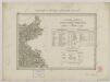
II. vojenské mapování 2
1 : 144000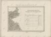
II. vojenské mapování 2
1 : 144000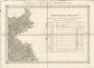
II. vojenské mapování 2
1 : 144000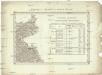
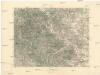
Umgebungen von Jägerndorf
Krnov-oblast (Česko) Enthoffer, J.
Podrobná mapa Markrabství moravského a Vévodství slezkého
1 : 100000 Krnov (Česko : oblast) Srp, Jan Jos. R. Vilímek
General-Karte erzherzoglich hoch und deutßchmeißterißchen Herrßchaft Freudenthal
1 : 1400 Bruntál (Česko : oblast) Riedel, Adolf

III. vojenské mapování 3959/4
1 : 25000

[Kartenblatt]
1 : 25000 Głubczyce (Polsko : oblast) Reichsamt für Landesaufnahme
[Kartenblatt]
1 : 25000 Heřmanovice (Česko) Reichsamt für Landesaufnahme
III. vojenské mapování 3959/3
1 : 25000
III. vojenské mapování 3959/1
1 : 25000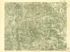
III. vojenské mapování 3959/1
1 : 25000
III. vojenské mapování 3959/3
1 : 25000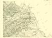
III. vojenské mapování 3959/4
1 : 25000

[Kartenblatt]
1 : 25000 Brumovice (Opava, Česko : oblast) Reichsamt für Landesaufnahme