Maps of Germany

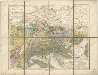
Geologische Karte von Deutschland und anlieg. Ländern

Fluss und Bergkarte von Deutschland und den anliegenden Ländern
Hand-Atlas über alle Theile der Erde und über das Weltgebäude Stieler, Adolf Justus Perthes
[Geologische Karte von Deutschland und den anlieg. Ländern]
Erster Band, enthaltend in vier Abtheilungen die Erscheinungen der anorganischen Natur: 1. Meteorologie und Klimatographie. 2. Hydrologie und Hydrographie. 3. Geologie. 4. Tellurischer Magnetismus Humboldt, Alexander von Verlag von Justus Perthes
Fluss- und Bergkarte von Deutschland und den anliegenden Ländern
Handatlas über alle Theile der Erde und über das Weltgebäude Stieler, Adolf Justus Perthes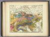
Geologische Karte von Deutschland und den anlieg.
1 : 4600000 Berghaus, Heinrich

[Fluss- u. Berg-Karte von Deutschland und den anlieg. Ländern]
Hand-Atlas über alle Theile der Erde nach dem neuesten Zustande und über das Weltgebäude Stieler, Adolf bei Justus Perthes
[Fluss- u. Berg-Karte von Deutschland und den anlieg. Ländern]
Hand-Atlas über alle Theile der Erde nach dem neuesten Zustande und über das Weltgebäude Stieler, Adolf bei Justus Perthes
[Fluss- u. Berg-Karte von Deutschland und den anlieg. Ländern]
Stieler's Hand-Atlas Stieler, Adolf bei Justus Perthes
Deutschland
mapa VKOL Petermann, August Justus Perthes
Deutschland
mapa VKOL Petermann, August Justus Perthes
Neueste Eisenbahn-Karte von Central-Europa
1 : 1900000 Evropa střední Hendschel, U. Carl Jügel
Hendschel's Post u. Reise Karte von Deutschland und den Nachbar-Staaten bis London, Paris, Montpellier, Florenz, Warschau, Kopenhagen &
Evropa střední Hendschel, U. Back, Jean Conr.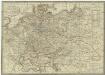
Neueste Post-Karte von Deutschland und dem grösten Theil der umliegenden Staaten oder Mittel-Europa
1 : 2350000 Evropa střední Fried, Franz List, C. Artaria
Post- Reise-Karte durch Deutschland und die angraenzenden Staaten zwischen London und Lublin, Koppenhagen und Mantua
Evropa střední Schmidt, O. F. Schropp, Simon Simon Schropp & Comp.
Mitteleuropa
1 : 3500000 Evropa střední Köcher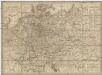
Neueste Post-Karte von Deutschland und demgrösten Theil der umliegenden Staaten oder Mitter-Europa
1 : 2340000 Evropa střední Fried, Franz List, Joseph bey Artaria et Compagnie
Střední Evropa v zájmu světového míru
1 : 5000000 Evropa střední Kuffner, Hanuš
Fluss Und Bergkarte Von Deutschland Und Den Anliegenden Landern.
1 : 4625000 Berghaus, Hermann
Deutschland um 1500
Deutschland Kunz, Andreas ; Moeschl, Joachim Robert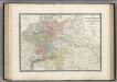
Allemagne en 1789.
1 : 3580000 Levasseur, E.
Reise-Karte von Mittel-Europa : mit Angabe der Bahnstationen und Postverbindungen / nach den neuesten Quellen entw. u. gezeichnet. von M. Hermann
1 : 2800000 Annotatie: Bijlage bij: J.C. König und Erhardt's Tages-Notizbuch Hermann, M. [S.l. : s.n.] / (Glogau : Flemming)
Deutschland 1803 nach dem Reichsdeputationshauptschluss
Deutschland Reichsdeputationshauptschluss Kunz, Andreas ; Moeschl, Joachim Robert
Deutschland um 1378
Deutschland Kunz, Andreas ; Moeschl, Joachim Robert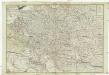
Neue und vollkomene Postkarte durch ganz Teutschland
1 : 2100000 Evropa jihovýchodní bey Artaria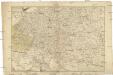
Neue und vollkomene Postkarte durch ganz Teutschland
1 : 2100000 Evropa jihovýchodní Artaria
Tabula Moderna Germanie [Karte], in: Claudii Ptolemei viri Alexandrini mathematice discipline philosophi doctissimi geographie opus [...], S. 245.
1 Karte aus Atlas Waldseemüller, Martin [und Ptolemaeus, Claudius] Übelin, Georg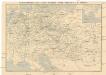
Eisenbahn-Routen-Karte von Mittel-Europa
Evropa střední Ritter, Julius R. v. Waldheim
Deutschland 1648
Deutschland Kunz, Andreas ; Moeschl, Joachim Robert