Maps of okres Ostrava-město

Moravská Ostrava a okolí

Moravská Ostrava a okolí
1 : 75000 Ostrava (Česko : oblast) Vojenský zeměpisný ústav

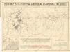
Přehledná mapa Ostravsko-Karviského kamenouhelného revíru

[Kartenblatt]
1 : 25000 Morava (Česko) Reichsamt für Landesaufnahme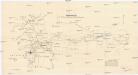
Uebersichts Karte des Ostrau-Karviner-Steinkohlrevieres
1 : 25000 Karviná (Česko : oblast) Jul. Kittl
Okresní hejtmanství Moravsko-Ostravské

Příloha k základnímu plánu upravovacímu obcí Regulačního sboru ostravského
1 : 25000 Ostrava-oblast (Česko) Vojenský zeměpisný ústav
Ostrava
III. vojenské mapování 4060/2
1 : 25000
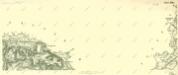
Meßtischblatt 6175 : Hultschin, 1883
1 : 250000 Hultschin. - Aufn. 1882. - 1:25000. - [Berlin]: Reichsamt für Landesaufnahme, 1883. - 1 Kt.
III. vojenské mapování 4061/3
1 : 25000
Gradkartenblatt
1 : 25000 Havířov-oblast (Česko) Gutwirth, Georg

Pharusův plán Moravská Ostrava


[Kartenblatt]
1 : 25000 Chuchelná (Česko) Reichsamt für Landesaufnahme
Gradkartenblatt
1 : 25000 Bohumín-oblast (Česko) Mayer, Johann
Meßtischblatt 6075 : Haatsch, 1942
1 : 250000 Haatsch. - Aufn. 1882, hrsg. 1883, bericht. 1939, hrsg. 1942. - 1:25000. - [Berlin]: Reichsamt für Landesaufnahme, 1942. - 1 Kt. : mehrfarb.
Meßtischblatt 6076 : Gr. Gorschütz, 1939
1 : 250000 Gr. Gorschütz. - Aufn. 1882, hrsg. 1884, bericht. 1928, letzte Na. - 1:25000. - [Berlin]: Reichsamt für Landesaufnahme, 1939. - 1 Kt.
Deutschleuten (Nemecko Lutin) - m0509-2-004 - Kaiserpflichtexemplar der Landkarten des stabilen Katasters
1 : 2880
Deutschleuten (Nemecko Lutin) - m0509-2-010 - Kaiserpflichtexemplar der Landkarten des stabilen Katasters
1 : 2880
Deutschleuten (Nemecko Lutin) - m0509-2-006 - Kaiserpflichtexemplar der Landkarten des stabilen Katasters
1 : 2880
Deutschleuten (Nemecko Lutin) - m0509-2-002 - Kaiserpflichtexemplar der Landkarten des stabilen Katasters
1 : 2880
Deutschleuten (Nemecko Lutin) - m0509-2-009 - Kaiserpflichtexemplar der Landkarten des stabilen Katasters
1 : 2880
Deutschleuten (Nemecko Lutin) - m0509-2-008 - Kaiserpflichtexemplar der Landkarten des stabilen Katasters
1 : 2880
Deutschleuten (Nemecko Lutin) - m0509-2-007 - Kaiserpflichtexemplar der Landkarten des stabilen Katasters
1 : 2880
Deutschleuten (Nemecko Lutin) - m0509-2-005 - Kaiserpflichtexemplar der Landkarten des stabilen Katasters
1 : 2880
Deutschleuten (Nemecko Lutin) - m0509-2-003 - Kaiserpflichtexemplar der Landkarten des stabilen Katasters
1 : 2880


