Maps of Olomouc

Katastrální mapy, regulační plány aj. města Olomouce

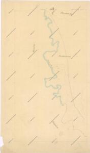
Bez Titulu: Okolí Olomouce

Übersichtskarte der Gegend um Olmütz
Olomouc-oblast (Česko) Domek
Olomouc
1 : 75000 Morava (Česko) Vojenský zeměpisný ústav
[Tschechoslowakie, Maßstab 1:75 000]. 4158, Olomouc : sonderausgabe : nur fur den dienstgebrauch
1 : 75000
Olmutz.; Spezialkarte der osterreichisch-ungarischen Monarchie.
from Spezialkarte der osterreichisch-ungarischen Monarchie. Austro-Hungarian Monarchy. Militärgeographisches Institut.,
Plan der königl. Hauptstadt Olmütz und Umgebung
1 : 2880 Olomouc-oblast (Česko) Schnizer, E. von Ed. Hölzel
Geologische Spezialkarte der... Österreichisch-Ungarischen Monarchie... Olmütz

Okolí olomucké
1 : 150000 Olomouc-oblast (Česko)
Geologische Spezialkarte der im Reichsrate vertretenen Königreiche und Länder der Österreichisch-Ungarischen Monarchie
1 : 75000 Olomouc (Česko : oblast) Tietze, Emil Ernst August Lipold, Markus Vincenc K. k. geologischen Reichsanstalt
Olomouc a okolí
1 : 75000 Olomouc (Česko : oblast) Vojenský zeměpisný ústav
Olmütz
1 : 75000 Loštice (Česko : oblast) Lampe K. u. k. Militärgeographisches Institut
III. vojenské mapování 4158
1 : 75000
Podrobná mapa Markrabství moravského a Vévodství slezkého
1 : 100000 Moravské markrabství Srp, Jan Jos. R. Vilímek
Podrobná místopisná mapa Království Českého

Karte der Umgebung von Olmütz
Olomouc-oblast (Česko) Lepař, Jan Raffelsperger, Franz
[Olomouc a okolí]
Prostějov-oblast (Česko) Lepař, Jan Raffelsperger, Franz
Eisenbahn Karte Wien-Dresden, Ollmütz-Trübau
1 : 72000 Blatt 9 Minarzik, Anselm J. Rauh
[Železniční trať Krasíkov-Olomouc]
1 : 60000 Krasíkov (Ústí nad Orlicí, Česko)
II. vojenské mapování 9
1 : 144000
Umgebungskarte von Olmütz
1 : 75000 Olomouc (Česko : oblast) K. u. k. Militärgeographisches Institut
II. vojenské mapování 9
1 : 144000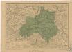
Generální mapa okresních hejtmanství
Komunikační mapa země Moravskoslezské
1 : 100000 Olomouc (Česko : oblast) Morslez. zem. výbor
Marchionatûs Moraviae Circulus Olumucensis
1 : 233300 Mollova mapová sbírka Müller, Johann Christoph Homann, Johann Baptista - dědici
Marchionatus Moraviae circulus Olomucensis
1 : 150000 Morava (Česko) Müller, Johann Christoph Homann, Johann Baptist J. B. Homann
[Marchionatus Moraviae circulus Preroviensis]
Morava (Česko) Müller, Johann Christoph Homann, Johann Baptist Io. Baptista Homanno
[Marchionatus Moraviae circulus Preroviensis]
Morava (Česko) Müller, Johann Christoph Homann, Johann Baptist Io. Baptista Homanno
Marchionatus Moraviae Circulus Olomoucensis