Maps of Honshu

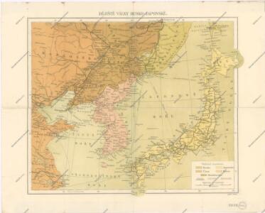
Dějiště války Rusko - Japonské

Dějiště války rusko-žaponské
1 : 4930000 Japonsko J. Otta
Dějiště války rusko-žaponské [sic]
1 : 4930000 Japonsko Roudný, R.
Mapa k rusko-žaponské válce
1 : 6400000 Japonsko Roudný, R.
Mapa k rusko-žaponské válce
Japonsko Lyttichius, Albertus Joachim Rhoeling, Paul J. Otta
Japan.
1 : 5000000 Vivien St Martin, L.
Kaart van Oost-Azië / J. Wackie
1 : 5000000 Annotatie: Met versterkte plaatsen (door landmacht en zeemacht); Gegevens verzameld over de periode/Data collected over the period: 1904; Annotatie geografische gegevens: Legenda J. Wackie Amsterdam : J.H. de Bussy
JAPANESE EMPIRE

Bojiště rusko-japonské ve východní Asii
1 : 4500000 Japonsko Kotrba, V.
Bojiště rusko-japonské ve východní Asii
1 : 4500000 Japonsko
Dmychova mapa rusko-japonského bojíště [sic]
1 : 5000000 Asie východní Dmych, Josef J. Dmych
et des Rojaumes de COREE ET IAPAN
Russisch - Japanische Kriegsschauplatz

Korea, Nordost-China und Süd-Japan
1 : 4500000 Korea Carl Flemming
JAPANESE EMPIRE-POLITICAL

Map of Korea and Manchuria
1 : 2450000 United States. Adjutant-General's Office. Military Information Division National Geographic Society
Korea, Nordost-China und Süd-Japan
1 : 4500000 Annotatie geografische gegevens: 3 schaalstokken; 3 inzetkrt.: Peking en omgeving. - 1:1.000.000. Tokio en omgeving. - 1:1.000.000. Söul en omgeving. - 1:1.666.666 Glogau : Carl Flemming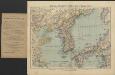
Korea, Nordost-China und Süd-Japan
1 : 4500000 [...] bearbeitet von A. Herrich Glogau : Carl Flemming
Japan and Korea.
1 : 6198300 Johnston, W. & A.K.
U.S.S.R. - Far East, Korea, Japan. Pergamon World Atlas.
1 : 5000000 Polish Army Topography Service
Japan and Korea. Iran (Persia), Afghanistan, and Baluchistan.
1 : 6190000 Hammond, C.S.
Iaponia [Karte], in: Gerardi Mercatoris Atlas, sive, Cosmographicae meditationes de fabrica mundi et fabricati figura, S. 541.
1 Karte aus Atlas Mercator, Gerhard Montanus, Petrus
TATARIAE SINENSIS MAPPA GEOGRAPHICA
1 : 5300000 Dálný východ (Rusko) Mayer, Tobias Anville, Jean-Baptiste Bourguinon d' curis Homannianorum Heredum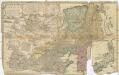
Tatariae Sinensis mappa geographica
1 : 5300000 Dálný východ (Rusko) Mayer, Tobias Anville, Jean-Baptiste Bourguinon d' curis Homannianorum Heredum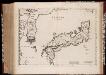
Iaponia Regnvm
1 : 4000000 Annotatie: Cum privilegio Sacrae Caesarae Majestatis & Ordinum Belgicae Foederatae; Origineel is Blad 197 in atlas factice; Annotatie geografische gegevens: Met 2 schaalstokken Amsterdam : Joannes Blaeu]
Japan a Korea
1 : 8000000 Japonsko nákladem J. Otty
Iaponia Regnum [Karte], in: Novus atlas Sinensis, S. 240.
1 Karte aus Atlas Martini, Martino Blaeu, Joan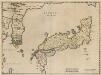
Iaponia Regnum. [Karte], in: Novus atlas absolutissimus, Bd. 11, S. 238.
1 Karte aus Atlas Janssonius Offizin
IAPONIA | REGNVM.
[Amsterdam : Joan Blaeu]