Maps of Horažďovice

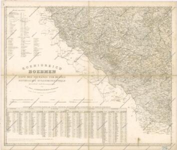
Koenigreich Boehmen...

Písek
1 : 75000 Blatná (Strakonice, Česko : oblast) Vojenský zeměpisný ústav
Pisek und Blatna
1 : 75000 Blatná (Strakonice, Česko : oblast) Petrakovič K. u. k. militär-geographisches Institut
Pisek und Blatna
1 : 75000 Blatná (Strakonice, Česko : oblast) K. u. k. Militärgeographisches Institut

Podrobné mapy zemí Koruny české v měřítku 1:75.000 a mapy vzdáleností všech míst při silnici ležících
1 : 75000 Horažďovice (Česko : oblast) Bělohlav, Josef F. Topič
Gradkartenblatt
1 : 25000 Radomyšl-oblast (Česko) Albrecht, Julius
Uibersichts-Karte der Herrschaft Drhovle
1 : 30700 Drhovle (Česko) Kraus Verlag des böhmischen Forstvereins
III. vojenské mapování 4252/3
1 : 25000
Přehledová mapa pozemků části velkostatku Štěkeň
1 : 25302
III. vojenské mapování 4252/3
1 : 25000
Podrobné mapy zemí Koruny české v měřítku 1:75.000 a mapa vzdáleností všech míst při silnici ležících. Strakonice - Horažďovice. Průvodce statisticko-historický po všech místech na těchto mapách uvedených a rejstřík věcný názvů hor, potoků, řek, rybníků atd. Sešit 30. List 33,
1 : 75000
Podrobné mapy zemí Koruny české v měřítku 1:75.000 a mapa vzdáleností všech míst při silnici ležících - Strakonice - Horažďovice. Průvodce statisticko-historický po všech místech na těchto mapách uvedených a rejstřík věcný názvů hor, potoků, řek, rybníků atd. Sešit 30. List 33,
1 : 75000
Mapa lesů a rybníků na statku Kestřany 1


Gradkartenblatt
1 : 25000 Horažďovice-oblast (Česko) Albrecht, Julius
III. vojenské mapování 4251/4
1 : 25000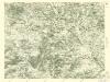
III. vojenské mapování 4251/4
1 : 25000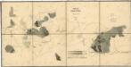
Porostní mapa polesí Štěkeň
1 : 10000
III. vojenské mapování 4252/1
1 : 25000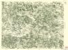
III. vojenské mapování 4252/1
1 : 25000
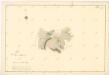
Plán pozemků dvora Rovná
1 : 7985
Bestandes Karte für die Excursionstour des böhmischen Forstvereins auf der Herrschaft Drhovle im August 1873
Drhovle (Česko) Buňata, Antonín André Verlag des böhmischen Forstvereins
Porostní mapa revíru Štěkeň a Rovná
1 : 11520
Sedlitz (Sedlice) - c6794-1-006 - Kaiserpflichtexemplar der Landkarten des stabilen Katasters
1 : 2880
Sedlitz (Sedlice) - c6794-1-008 - Kaiserpflichtexemplar der Landkarten des stabilen Katasters
1 : 2880
Sedlitz (Sedlice) - c6794-1-002 - Kaiserpflichtexemplar der Landkarten des stabilen Katasters
1 : 2880
Sedlitz (Sedlice) - c6794-1-007 - Kaiserpflichtexemplar der Landkarten des stabilen Katasters
1 : 2880
Sedlitz (Sedlice) - c6794-1-003 - Kaiserpflichtexemplar der Landkarten des stabilen Katasters
1 : 2880
Sedlitz (Sedlice) - c6794-1-001 - Kaiserpflichtexemplar der Landkarten des stabilen Katasters
1 : 2880
Sedlitz (Sedlice) - c6794-1-009 - Kaiserpflichtexemplar der Landkarten des stabilen Katasters
1 : 2880
Sedlitz (Sedlice) - c6794-1-005 - Kaiserpflichtexemplar der Landkarten des stabilen Katasters
1 : 2880