Maps of Massachusetts

Special -Karte der Vereinigten Staaten von Nord - America No 8.

Kaart van Nieuw Nederland / [getekend door] R. van Wijk
Dordrecht : J. de Vos
Bridge by which the South Mountain & Boston R.R. is to cross the Hudson River at Poughkeepsie, N.Y. ; The Map of South Mountain and Boston
from New illustrated atlas of Dutchess County, New York. / Compiled & drawn from personal examinations, surveys etc. under the personal supervision of O.W. Gray & Son and F.A. Davis, and published under the superintendence of H. L. Kochersperger.
New York, New Jersey, Massachusetts, Connecticut, Rhode Island.
1 : 1584000 Smith, J. Calvin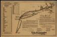
Via RCA, a direct marine radio service to and from ships at sea

Pensylvania Nova Jersey et Nova York cum regionibus ad fluvium Delaware in America sitis, nova delineatione ob oculos posita
1 : 2200000 New Jersey Lotter, Tobias Conrad per Tob. Conr. Lotter
Map of Massachusetts, Connecticut and Rhode Island : constructed from the latest authorities
1 : 700000 Vance, D. H. (David H.) A. Finley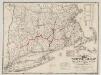
The "centennial" postal statistical map of Massachusetts, Rhode Island and Connecticut : showing railroads, post routes and offices together with population and valuation of cities and towns
1 : 422400 Cook and Ellis (Firm) M.G. Cook and Frank O. Ellis
Delaware, from the best authorities / W. Barker, sculp., Philada.
from Carey's American atlas.
Map of the New York & Boston Railway : with its connections with other railways
Swett and Powers (Firm) Swett & Powers
A map of Massachusetts, Connecticut and Rhodeisland
1 : 424000 Ruggles, Edward, fl. 1789-1817 [s.n.]
Pas-Kaart vande zee kusten van Niew Nederland anders genaamt Niew York : tusschen Renselaars Hoek en de Staaten Hoek / door C. J. Vooght, geometra.
from Charts and maps
The north eastern coast, North America, New York to Cape Canso (west sheet)
1 : 910000 Wadsworth, A. S. (Alex. S.)
The provinces of New York, and New Jersey : with part of Pensilvania, and the governments of Trois Rivieres, and Montreal / drawn by Capt. Holland ; engraved by Thomas Jefferys, geographer to His Majesty.
from Parts
County map of Massachusetts, Connecticut, and Rhode Island.
from New general atlas.
[Map of railroad lines from New York to Springfield, Mass.]
J.H. Bufford & Co Bufford & Co. Lith.
Gay Head to Cape Henlopen
1 : 400000 Hassler, F. R.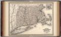
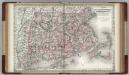
Massachusetts, Connecticut, and Rhode Island.
1 : 660000 Johnson, A.J.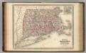
Massachusetts, Connecticut, and Rhode Island.
1 : 660000 Johnson, A.J.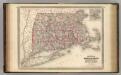
Massachusetts, Connecticut, and Rhode Island.
1 : 660000 Johnson, A.J.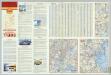
Various Regions and Cities in New England.
Shell Oil Company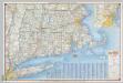
Shell Highway Map of Massachusetts, Connecticut, Rhode Island.
1 : 570240 Shell Oil Company
Massachusetts, Connecticut, Rhode Island.
1 : 688000 Finley, Anthony
Railroad Map Featuring Many Northeastern States Rhode Island Connecticut Massachusetts
1 : 2000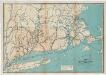
Map of the railroads of Connecticut : to accompany the report of the railroad commissioners
1 : 383000 Dodd Lithographic Co.
Part of New England, New York, east New Iarsey and Long Iland.
from Parts
New England and New York in 1697

Massachusetts
1 : 490000 Sotzmann, D. F Bey Carl Ernst Bohn
Massachusetts, Connecticut, And Rhode Island.
1 : 570240 Johnson, A.J.