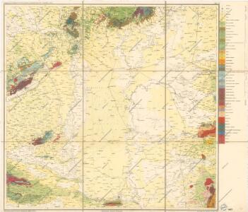
Maps of Alföld

Geologishe Übersichtskarte der Österreichischen Monarchie...

Blatt VII, uit: Geologische Übersichts-Karte der Österreichisch-Ungarischen Monarchie / nach den Aufnahmen der K.K. Geologischen Reichsanstalt bearb. von Franz Ritter von Hauer ; gezeichn. von Eduard Jahn
1 : 576000 Annotatie geografische gegevens: Gebaseerd op veldwerk in de jaren 1850 tot 1865 Hauer, Franz Ritter von; Jahn, Eduard; Kaiserlich-Königliche Geologische Reichsanstalt, Wenen Wien : Beck
Mappa Generalis in Qua Danubii Fl. Caetium Montem inter et Bulgariae Flumen Jantram, Intercepti Tractus Integer In Subsequentibus XVIII. Secrionibus Divisim Specialissimè Exhibendus Repraesentatur. Notandum Sectionibus illis Lineolas per Transversum Secantes Danubium Iisque Interpositos Numeros Respondere
1 : 100000 Mollova mapová sbírka Marsili, Luigi Ferdinando
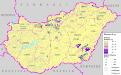
Automapa Maďarska
Rumänen in Ungarn (2001) und ihre Selbstverwaltung (2004)
Ungarn Rumänen, Selbstverwaltung Bottlik, Zsolt
Rumänen auf dem Gebiet des heutigen Ungarn 1910
Ungarn Rumänen Bottlik, Zsolt
Verwaltungsorgane der sonstigen Minderheiten Ungarns (2004)
Ungarn Minderheiten, Selbstverwaltung Bottlik, Zsolt
Slowaken in Ungarn 1990
Ungarn Slowaken Bottlik, Zsolt
Slowenen in Ungarn (2001) und ihre Selbstverwaltung (2004)
Ungarn Slowenen, Selbstverwaltung Bottlik, Zsolt
Rumänen in Ungarn 1990
Ungarn Rumänen Bottlik, Zsolt
Az egyéb bevett nemzetiségek kisebbségi önkormányzatai (2004) Magyarországon
Ungarn Minderheiten, Selbstverwaltung Bottlik, Zsolt
Kroaten auf dem Gebiet des heutigen Ungarn 1910
Ungarn Kroaten Bottlik, Zsolt
Oesterreichisch-Ungarische Monarchie
Deutsche auf dem Gebiet des heutigen Ungarn 1910
Ungarn Deutsche Bottlik, Zsolt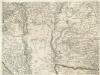
Augustissimo Romanor. Imperatori Iosepho I. Hungaria Regi Invictissimo Mappam Hanc Regni Hungariae
1 : 540000 Mollova mapová sbírka Müller, Johann Christoph
Kroaten in Ungarn 1990
Ungarn Kroaten Bottlik, Zsolt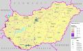
Kroaten in Ungarn (2001) und ihre Selbstverwaltung (2004)
Ungarn Kroaten, Selbstverwaltung Bottlik, Zsolt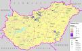
Slowaken in Ungarn (2001) und ihre Selbstverwaltung (2004)
Ungarn Slowaken, Selbstverwaltung Bottlik, Zsolt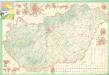
Magyarország Autóúttérképe
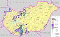
Slowaken auf dem Gebiet des heutigen Ungarn 1910
Ungarn Slowaken Bottlik, Zsolt
Letecká mapa Evropy

Ungarn. Comitate: Raab, Comorn, Stuhlweißenburg, Weszprim, Zolna, Pesth, Neograd, Hont, Gran, Bars, Neutra, Gömör, Heves, Borsod, Lorna, Abanjvár, Zemplin, Szabolcs, Bihar, Békes, Csongrad, Arad. Jazigien, klein und groß. Kumanien, Hajduken Städte
Ungarn Verkehrsweg
Vermehrte und Verbesserte Landkarten des Königreichs Ungarn :
1 : 500000 Mollova mapová sbírka Stier, Martin Böner, Johann-Alexander Endter, Martin
Die Donau, der Fürst aller Europaeischen Flüsse :
Mollova mapová sbírka Hoffmann, Johannes Hoffmann, Johann
Nieder Ungern
Maďarsko Kipferling, Karl Joseph Benedict, Anton im Verlage des Kunst- und Industrie Comptoirs
Nieder Ungern
Maďarsko Kipferling, Karl Joseph Benedict, Anton im Verlage des Kunst- und Industrie Comptoirs
Hungaria
Mollova mapová sbírka Hoffmann, Johannes Hoffmann, Johann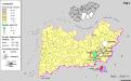
A szlovákok településterülete a szomszédsági mutató alapján Dél-Alföldön 1941-ban
Ungarn (Süd) Slowaken, Siedlung Bottlik, Zsolt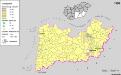
A szlovákok településterülete a szomszédsági mutató alapján Dél-Alföldön 1980-ban
Ungarn (Süd) Slowaken, Siedlung Bottlik, Zsolt