Maps of okres Liberec

Mapa okresních hejtmanství Libereckého a Jabloneckého

Jizerské hory

Touristen-Karte vom Jeschken- u. Isergebirge
1 : 80000 Ještědský hřbet (Česko) Straube, Julius Matouschek, Josef Paul Sollors Nachf.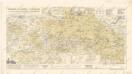
Wegkarte vom Jescken und Isergebirge mit... Teilen des Lausitzer und Riesengebirges

Karte der Bezirkshauptmannschaften Reichenberg und Gablonz
1 : 100000 Jablonec nad Nisou-oblast (Česko) Erben, Josef Karl Janský
Karte des Bezirkes Reichenberg

Karte der Reichenberger Bezirkshauptmannschaft
1 : 70000 Liberec-oblast (Česko) Medau, Karel Vilém Lehrpersonale der Leitmeritzer k.k. Hauptschule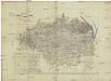
Karte der Reichenberger Bezirkshauptmannschaft
1 : 71000 Liberec-oblast (Česko) Lehrpersonale der Hauptschule
Liberec a okolí
1 : 75000 Liberec (Česko : oblast) Vojenský zeměpisný ústav
Reichenberg u. Friedland.
from Spezialkarte der osterreichisch-ungarischen Monarchie.
Generální mapa okresních hejtmanství

Generální mapa okresních hejtmanství

Umgebungskarte zu Woerl's Führer
1 : 220000 Liberec-oblast (Česko) Woerl's Reisebücherverlag
Podrobná mapa Království českého, Markrabství moravského a Vévodství slezského
1 : 100000 Jablonec nad Nisou (Česko : oblast) Srp, Jan Jos. R. Vilímek
Jablonec n. N. a okolí
1 : 75000 Jablonec nad Nisou (Česko : oblast) Vojenský zeměpisný ústav
Mapka Jizerských hor
1 : 150000 Jizerské hory (Česko a Polsko : oblast) Ed. Grégr
Reichenberg u. Friedland
1 : 75000 Frýdlant (Česko : oblast) Reichenauer K. u. k. Militärgeographisches Institut
Reichenberg u. Friedland
1 : 75000 Frýdlant (Česko : oblast) Reichenauer K. u. k. Militärgeographisches Institut
Reichenberg u[nd] Friedland
1 : 75000 Frýdlant (Česko : oblast) K. u. k. Militärgeographisches Institut
Der politische Bezirk Gablonz


Liberec
1 : 75000 Liberec-oblast (Česko) Vojenský zeměpisný ústav
Liberec
1 : 75000 Liberec (Česko : oblast) Vojenský zeměpisný ústav
Liberec
1 : 75000 Liberec-oblast (Česko) Vojenský zeměpisný ústav
Iser-Gebirge
1 : 75000 Jizerské hory (Česko a Polsko : oblast) Alexander Köhler
Liberec
1 : 75000 Frýdlant (Česko : oblast) Vojenský zeměpisný ústav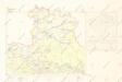
Mapy plánování ČSR

Podrobné mapy zemí Koruny české v měřítku 1:75.000 a mapa vzdáleností všech míst při silnici ležících
1 : 75000 Harrachov (Semily, Česko : oblast) Bělohlav, Josef F. Topič
Podrobné mapy zemí Koruny české v měřítku 1:75.000 a mapa vzdáleností všech míst při silnici ležících - Jablonec - Roketnice - Žel. Brod. Průvodce statisticko-historický po všech místech na těchto mapách uvedených a rejstřík věcný názvů hor, potoků, řek, rybníků atd. Sešit 11. List 78,
1 : 75000


