Maps of Norfolk

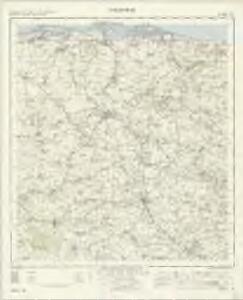
Fakenham - OS One-Inch Map
1 : 63360 Topographic maps Ordnance Survey Ordnance Survey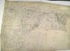
Wells
1 : 31680 This plan covers the North Norfolk coast and features some of the most distinctive salt-marshes, inter-tidal flats, dunes, shingle and grazing marshes in Europe. Near Wells-next-the-Sea is Holkham Park with its triumphal arch indicated along the southern approach. This was the path visitors from London and Newmarket would have taken to Wells. At the highest point of the park, aligned with the arch, is the obelisk of Holkham Park Mansion and Kent's North Lodges. Budgen, Charles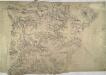
East Dereham
1 : 31680 The western boundary of this plan is formed by the Peddars Way, a Roman road laid down circa AD61. The ruins of Castle Acre are depicted along this road. Excavations here have uncovered a unique grain-processing plant, comprising a granary, a barn, a kilnhouse, a malthouse and a brewhouse. To the north-east of the castle are the ruins of a former priory belonging to the Cluniac Order, set on an incline above the River Nar. This small river, highlighted in blue on the plan, provided the priory with the greater part of its water supply via a 'monastic drain' - a general descriptive term for fenland drainage systems characterised by large overflow ditches. Metcalf, Edward B.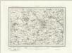
Fakenham (Outline) - OS One-Inch Revised New Series
1 : 63360 Topographic maps Ordnance Survey Ordnance Survey
Fakenham (Hills) - OS One-Inch Revised New Series
1 : 63360 Topographic maps Ordnance Survey Ordnance Survey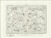
Swaffham (Outline) - OS One-Inch Revised New Series
1 : 63360 Topographic maps Ordnance Survey Ordnance Survey
Swaffham (Hills) - OS One-Inch Revised New Series
1 : 63360 Topographic maps Ordnance Survey Ordnance Survey
Wells next the Sea (Hills) - OS One-Inch Revised New Series
1 : 63360 Topographic maps Ordnance Survey Ordnance Survey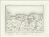
Wells next the Sea (Outline) - OS One-Inch Revised New Series
1 : 63360 Topographic maps Ordnance Survey Ordnance Survey
Fakenham
1 : 31680 This plan covers north-west Norfolk, an area characterised by arable and grassland interspersed with mixed woodland. Rainham Park at lower right and Melton Park in the centre are good examples of 18th-century formal gardens. Isolated villages and dispersed farms represent the dominant settlement pattern in an area made up of large private estates. Metcalf, Edward B.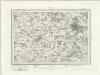
Norwich (Outline) - OS One-Inch Revised New Series
1 : 63360 Topographic maps Ordnance Survey Ordnance Survey
Norwich (Hills) - OS One-Inch Revised New Series
1 : 63360 Topographic maps Ordnance Survey Ordnance Survey
Aylsham (Hills) - OS One-Inch Revised New Series
1 : 63360 Topographic maps Ordnance Survey Ordnance Survey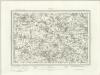
Aylsham (Outline) - OS One-Inch Revised New Series
1 : 63360 Topographic maps Ordnance Survey Ordnance Survey
Cromer (Hills) - OS One-Inch Revised New Series
1 : 63360 Topographic maps Ordnance Survey Ordnance Survey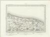
Cromer (Outline) - OS One-Inch Revised New Series
1 : 63360 Topographic maps Ordnance Survey Ordnance Survey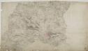
Norwich 23
1 : 31680 This plan covers part of Norfolk with the county town of Norwich,depicted at lower right., Built,on a hill, Norwich was of strategic importance to the invading Saxons, Romans and Normans.,,Light pencil interlining ('hachuring') is employed to represent the slight undulation,and the low hills of this part of East Anglia., The landscape is characterised by fertile farmland with a few woodland areas and wild heaths. Budgen, Charles
TG04 - OS 1:25,000 Provisional Series Map
1 : 25000 Topographic maps Ordnance Survey Ordnance Survey
TG03 - OS 1:25,000 Provisional Series Map
1 : 25000 Topographic maps Ordnance Survey Ordnance Survey
TF94 - OS 1:25,000 Provisional Series Map
1 : 25000 Topographic maps Ordnance Survey Ordnance Survey
TG02 - OS 1:25,000 Provisional Series Map
1 : 25000 Topographic maps Ordnance Survey Ordnance Survey
TG10 - OS 1:25,000 Provisional Series Map
1 : 25000 Topographic maps Ordnance Survey Ordnance Survey
TF93 - OS 1:25,000 Provisional Series Map
1 : 25000 Topographic maps Ordnance Survey Ordnance Survey
TG01 - OS 1:25,000 Provisional Series Map
1 : 25000 Topographic maps Ordnance Survey Ordnance Survey
TF84 - OS 1:25,000 Provisional Series Map
1 : 25000 Topographic maps Ordnance Survey Ordnance Survey
TF92 - OS 1:25,000 Provisional Series Map
1 : 25000 Topographic maps Ordnance Survey Ordnance Survey
TG00 - OS 1:25,000 Provisional Series Map
1 : 25000 Topographic maps Ordnance Survey Ordnance Survey
TF83 - OS 1:25,000 Provisional Series Map
1 : 25000 Topographic maps Ordnance Survey Ordnance Survey
TF91 - OS 1:25,000 Provisional Series Map
1 : 25000 Topographic maps Ordnance Survey Ordnance Survey