Maps of Denbighshire

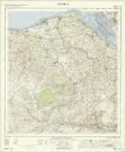
Denbigh - OS One-Inch Map
1 : 63360 Topographic maps Ordnance Survey Ordnance Survey
Ruthin
1 : 31680 This plan covers a section of the Cambrian Mountains from Denbigh in the Vale of Clwyd, at the top, to the valley of the River Dee, which forms a boundary at the bottom right of the map. The drawing is formally titled and the area of the land recorded as 181.1792 square miles. Archaeological sites are named in gothic script. Colour washes depicting relief are combined with numerical annotations of altitude ('spot heights') in black ink. A key to interpreting the mineral content of the landscape survives just below the area calculation table. Entitled 'Mineral Notives', it uses symbols to distinguish limestone, red sandstone, greywacke slate and alluvium. Declivity ('downward tilts') in the land are shown in red by an arrow and angular value. Dawson, Robert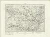
Corwen (Outline) - OS One-Inch Revised New Series
1 : 63360 Topographic maps Ordnance Survey Ordnance Survey
Corwen (Hills) - OS One-Inch Revised New Series
1 : 63360 Topographic maps Ordnance Survey Ordnance Survey
Denbigh (Hills) - OS One-Inch Revised New Series
1 : 63360 Topographic maps Ordnance Survey Ordnance Survey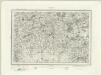
Denbigh (Outline) - OS One-Inch Revised New Series
1 : 63360 Topographic maps Ordnance Survey Ordnance Survey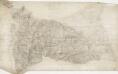
St. Asaph
1 : 31680 This plan of a section of the Vale of Clwyd is formally titled with the scale of the drawing noted and the area of the land recorded as 188.84 square miles. Archaeological sites are named in gothic script. Colour washes depicting relief are combined with numerical annotations ('spot heights') in red and black ink, indicating the height of the hills. The altitudes shown in red ink have been trigonometrically ascertained; those in black are estimated. Dawson, Robert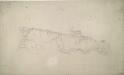
Llangollen
1 : 31680 A triangulation diagram appears on the reverse of this drawing. This enabled draughtsmen to plot the exact location of topographical features. Mileage is indicated on major communication routes, accompanied by abbreviations of the town names from which distance has been measured. For example, the abbreviation 'MS L''2' indicates two miles from Llangollen. Archaeological sites are named in gothic script. A triangulation grid is faintly visible in the left hand portion of the drawing, and pencil lines radiate from trigonometrical stations, marked by dots within triangles. Durrant, William R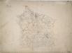
Mold
1 : 31680 A triangulation diagram appears on the reverse of this diagram, enabling the draughtsman to plot features of the landscape with precision. An area calculation is also written on the back of the sheet. At Northop, pencil lines radiate from a dot within a red triangle. This is a trigonometrical station from which angular measurements were taken. The ancient Watts Dike is named in gothic script; the standard presentation after 1816, when the inclusion of archaeological features became obligatory. A note in the bottom left of the drawing gives the date on which the drawing was received in the Tower - one of the few plans to do so. Giles, John C.
Mostyn Hall
1 : 31680 .A triangulation diagram appears on the reverse of this drawing. This enabled the draughtsman to plot features of the landscape with precision.,A trigonometrical point is marked at Air Lighthouse at the top of the plan. Pencil lines radiate from this point, indicating the angular measurements taken from here. Archaeological sites are,labelled,in gothic script. ,'Tumuli' (ceremonial burial mounds) are marked in this way in several places. Durrant, William R
Bodferry
1 : 31680 .Lieutenant Alexander W Robe's pencil inscription at the bottom of this drawing reads: "Some mistake must have been made in the construction of this piece of work that it will be considered necessary to lay it down afresh as I find it will not fit the trig and coincide with the edges of the plans to the West, Nos. 309 and 323." An area calculation table survives in black ink in the top-left margin with the area totalling 18.86 square miles. Colour washes depicting relief are combined with numerical annotations in red where spot heights have been measured. Archaeological details are noted in gothic lettering. Dawson, Robert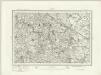
Flint (Outline) - OS One-Inch Revised New Series
1 : 63360 Topographic maps Ordnance Survey Ordnance Survey
Flint (Hills) - OS One-Inch Revised New Series
1 : 63360 Topographic maps Ordnance Survey Ordnance Survey
Wrexham (Hills) - OS One-Inch Revised New Series
1 : 63360 Topographic maps Ordnance Survey Ordnance Survey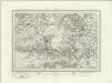
Wrexham (Outline) - OS One-Inch Revised New Series
1 : 63360 Topographic maps Ordnance Survey Ordnance Survey
Cyrn y Brain
1 : 31680 The county boundary of Denbighshire and Flintshire is indicated here by a red pecked line. The plan is formally titled, with a note in the top left corner explaining that it has been copied from the original protraction with north facing upwards instead of true. A triangulation diagram appears on the reverse of the drawing: this enabled the draughtsman to plot with prominent topographical features with precision. Many pencil lines radiate from a trigonometrical point at Cefny Fedw, indicated by a dot within a triangle. These represent the angular measurements taken from this point. Giles, John C.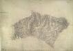
Llanwrst
1 : 31680 Below the formal title of this plan of Snowdonia, in the top left margin, is an area calculation table in black ink. Brushwork interlining ('hachuring') and colour washes are combined with numerical annotations to describe the relative relief and height of the land. The altitudes recorded in red ink are trigonometrically ascertained: those in black are estimated. Dawson, Robert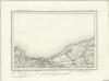
Rhyl (Outline) - OS One-Inch Revised New Series
1 : 63360 Topographic maps Ordnance Survey Ordnance Survey
Rhyl (Hills) - OS One-Inch Revised New Series
1 : 63360 Topographic maps Ordnance Survey Ordnance Survey
Llandrillo
1 : 31680 This,original protraction is formally titled. The traverse routes are noted with the relevant dates and Ordnance Survey field-book page numbers. The conventional sign of a dot within a triangle indicates a trigonometrical point. These appear around the edges of the drawing in red ink,,marking the points from which the surveyor took angular measurements to plot features of the landscape. , Collard, Thomas W.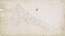
Flint
1 : 31680 A note in the bottom left corner of this drawing records the date it was received at the Drawing Office in the Tower of London, where final reduced copies of the plans were made. It is one of the few drawings to make reference to the Tower. A triangulation drawing appears on the reverse, along with an area calculation, referred to in its formal title. Major communication routes are highlighted in yellow, following standard military cartographic convention. Hughes, Herbert J.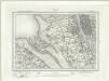
Liverpool (Outline) - OS One-Inch Revised New Series
1 : 63360 Topographic maps Ordnance Survey Ordnance Survey
Liverpool (Hills) - OS One-Inch Revised New Series
1 : 63360 Topographic maps Ordnance Survey Ordnance Survey
SH97 - OS 1:25,000 Provisional Series Map
1 : 25000 Topographic maps Ordnance Survey Ordnance Survey
SH96 - OS 1:25,000 Provisional Series Map
1 : 25000 Topographic maps Ordnance Survey Ordnance Survey
SH95 - OS 1:25,000 Provisional Series Map
1 : 25000 Topographic maps Ordnance Survey Ordnance Survey
SJ07 - OS 1:25,000 Provisional Series Map
1 : 25000 Topographic maps Ordnance Survey Ordnance Survey
SH94 - OS 1:25,000 Provisional Series Map
1 : 25000 Topographic maps Ordnance Survey Ordnance Survey
SJ06 - OS 1:25,000 Provisional Series Map
1 : 25000 Topographic maps Ordnance Survey Ordnance Survey