Maps of Clackmannanshire

Perth and Clackmannan Sheet CXL - OS 6 Inch map
1 : 10560 Topographic maps Ordnance Survey Ordnance Survey
Perth and Clackmannan Sheet CXL - OS 6 Inch map
1 : 10560 Topographic maps Ordnance Survey Ordnance Survey
Perth and Clackmannan Sheet CXL.NE - OS 6 Inch map
1 : 10560 Topographic maps Ordnance Survey Ordnance Survey
NS99 - OS 1:25,000 Provisional Series Map
1 : 25000 Topographic maps Ordnance Survey Ordnance Survey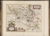
Sterlinensis praefectura, [vulgo], Sterlin-Shyr / Auct. Timoth. Pont.
Pont, Timothy, 1560?-1614? Blaeu, Joan, 1596-1673
Stirling - OS One-Inch map
1 : 63360 Topographic maps Ordnance Survey Ordnance Survey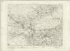
Stirling - OS One-Inch map
1 : 63360 Topographic maps Ordnance Survey Ordnance Survey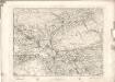
Stirling - OS One-Inch map
1 : 63360 Topographic maps Ordnance Survey Ordnance Survey
Stirling & Dunfermline (67) - OS One-Inch map
1 : 63360 Topographic maps Ordnance Survey Ordnance Survey
Stirling & Dunfermline (67) - OS One-Inch map
1 : 63360 Topographic maps Ordnance Survey Ordnance Survey
Sterlinensis præfectvra
1 Karte : Kupferdruck ; 40 x 51 cm Blaeu; Pont Joan Blaeu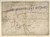
[A map of Strath Devon and the district between the Ochils and the Forth]
Adair, John, ca. 1650-1722
STERLINENSIS | PRÆFECTVRA. | STERLIN-SHYR.
Auct. Timoth Pont. [Amsterdam : Joan Blaeu]
Perth and Alloa - OS One-Inch Map
1 : 63360 Topographic maps Ordnance Survey Ordnance Survey
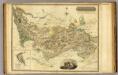
Fife, Kinross - Bartholomew's 'Survey Atlas of Scotland'
1 : 126720 Topographic maps John Bartholomew & Son, Ltd John Bartholomew & Son, Ltd
Map of the counties of Fife and Kinross.
Greenwood, Christopher, 1786-1855 Fowler, William, fl. 1818-1863 Sharp, T.
Map of the counties of Fife and Kinross.
Greenwood, Christopher, 1786-1855 Fowler, William, fl. 1818-1863 Sharp, T.
Map of the counties of Fife and Kinross.
Greenwood, Christopher, 1786-1855 Fowler, William, fl. 1818-1863 Sharp, T.
Counties of Fife and Kinross with the Rivers Forth and Tay
Ainslie, John, 1745-1828
Map of the counties of Fife and Kinross.
Greenwood, Christopher, 1786-1855 Fowler, William, fl. 1818-1863 Sharp, T.
Counties of Fife and Kinross with the Rivers Forth and Tay
Ainslie, John, 1745-1828
Counties of Fife and Kinross with the Rivers Forth and Tay
Ainslie, John, 1745-1828
Counties of Fife and Kinross with the Rivers Forth and Tay
Ainslie, John, 1745-1828
Counties of Fife and Kinross with the Rivers Forth and Tay
Ainslie, John, 1745-1828
Counties of Fife and Kinross with the Rivers Forth and Tay
Ainslie, John, 1745-1828
Fife with Kinross Shire.
Thomson, John, 1777- ca. 1840 Johnson, William, fl. 1806-1840
Fife with Kinross Shire.
Thomson, John, 1777- ca. 1840 Johnson, William, fl. 1806-1840
Lothian and Linlitquo / Joh. et Cornelius Blaeu exc.
Blaeu, Joan 1596-1673 Blaeu, Cornelius, d.1644
Provincae Lauden seu Lothien et Linlitouo
1 : 160000 [Amstelodami] : [apud Joannem Janssonium]