Maps of Outer Hebrides

Inverness-shire (Hebrides), Sheet XXX - OS 6 Inch map
1 : 10560 Topographic maps Ordnance Survey Ordnance Survey
Inverness-shire - Hebrides Sheet XXX - OS 6 Inch map
1 : 10560 Topographic maps Ordnance Survey Ordnance Survey
Inverness Hebrides, Sheet XXX.5 (North Uist) - OS 25 Inch map
1 : 2500 Topographic maps Ordnance Survey Ordnance Survey
Inverness-shire - Hebrides, Sheet 030.05 - 25 Inch Map
1 : 2500 Topographic maps Ordnance Survey Ordnance Survey
Inverness Hebrides, Sheet XXX.9 (North Uist) - OS 25 Inch map
1 : 2500 Topographic maps Ordnance Survey Ordnance Survey
Inverness-shire - Hebrides, Sheet 030.09 - 25 Inch Map
1 : 2500 Topographic maps Ordnance Survey Ordnance Survey
Inverness Hebrides, Sheet XXX.10 (North Uist) - OS 25 Inch map
1 : 2500 Topographic maps Ordnance Survey Ordnance Survey
Inverness-shire - Hebrides, Sheet 030.06 - 25 Inch Map
1 : 2500 Topographic maps Ordnance Survey Ordnance Survey
Inverness Hebrides, Sheet XXX.6 (North Uist) - OS 25 Inch map
1 : 2500 Topographic maps Ordnance Survey Ordnance Survey
Inverness-shire - Hebrides, Sheet 030.10 - 25 Inch Map
1 : 2500 Topographic maps Ordnance Survey Ordnance Survey
Inverness Hebrides, Sheet XXX.15 (North Uist) - OS 25 Inch map
1 : 2500 Topographic maps Ordnance Survey Ordnance Survey
Inverness-shire - Hebrides, Sheet 030.11 - 25 Inch Map
1 : 2500 Topographic maps Ordnance Survey Ordnance Survey
Inverness-shire - Hebrides, Sheet 030.15 - 25 Inch Map
1 : 2500 Topographic maps Ordnance Survey Ordnance Survey
Inverness Hebrides, Sheet XXX.11 (North Uist) - OS 25 Inch map
1 : 2500 Topographic maps Ordnance Survey Ordnance Survey
Inverness Hebrides, Sheet XXX.12 (North Uist) - OS 25 Inch map
1 : 2500 Topographic maps Ordnance Survey Ordnance Survey
Inverness-shire - Hebrides, Sheet 030.12 - 25 Inch Map
1 : 2500 Topographic maps Ordnance Survey Ordnance Survey
Inverness-shire - Hebrides, Sheet 029.16 - 25 Inch Map
1 : 2500 Topographic maps Ordnance Survey Ordnance Survey
Inverness Hebrides, Sheet XXIX.16 (North Uist) - OS 25 Inch map
1 : 2500 Topographic maps Ordnance Survey Ordnance Survey
Volume 3: Sheet 89 - Sollas
1 : 63360 Farquharson, J.
Sollas - OS One-Inch map
1 : 63360 Topographic maps Ordnance Survey Ordnance Survey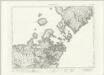
Sollas - OS One-Inch map
1 : 63360 Topographic maps Ordnance Survey Ordnance Survey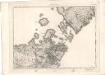
Sollas - OS One-Inch map
1 : 63360 Topographic maps Ordnance Survey Ordnance Survey
Sollas (22) - OS One-Inch map
1 : 63360 Topographic maps Ordnance Survey Ordnance Survey
Sollas (22) - OS One-Inch map
1 : 63360 Topographic maps Ordnance Survey Ordnance Survey
North Uist - OS One-Inch Map
1 : 63360 Topographic maps Ordnance Survey Ordnance Survey
Vistus Insula, vulgo Viist, cum aliis minoribus ex Aebudarum numero ei ad meridiem adjacentibus / Auct. Timotheo Pont.
Pont, Timothy, 1560?-1614? Blaeu, Joan, 1596-1673
North and South Uist - Bartholomew's 'Survey Atlas of Scotland'
1 : 126720 Topographic maps John Bartholomew & Son, Ltd John Bartholomew & Son, Ltd
Vistvs insvla, vulgo Viist
1 Karte : Kupferdruck ; 44 x 56 cm Blaeu; Pont Joan Blaeu
Uist & Barra, Sheet 18 - Bartholomew's "Half Inch to the Mile Maps" of Scotland
1 : 126720 Topographic maps John Bartholomew & Son, Ltd John Bartholomew & Son, Ltd


