Maps of Bradford

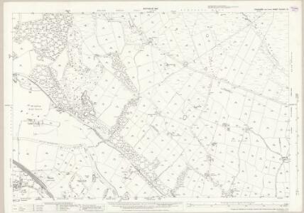
Yorkshire CLXXXV.12 (includes: Keighley; Silsden) - 25 Inch Map
1 : 2500 Topographic maps Ordnance Survey Ordnance Survey
Yorkshire CLXXXV.12 (includes: Keighley; Silsden) - 25 Inch Map
1 : 2500 Topographic maps Ordnance Survey Ordnance Survey
Yorkshire CLXXXV.12 (includes: Keighley; Silsden) - 25 Inch Map
1 : 2500 Topographic maps Ordnance Survey Ordnance Survey
Yorkshire CLXXXV.12 (includes: Keighley; Silsden) - 25 Inch Map
1 : 2500 Topographic maps Ordnance Survey Ordnance Survey
Yorkshire CLXXXV.SE - OS Six-Inch Map
1 : 10560 Topographic maps Ordnance Survey Ordnance Survey
Yorkshire CLXXXV.SE - OS Six-Inch Map
1 : 10560 Topographic maps Ordnance Survey Ordnance Survey
Yorkshire CLXXXV.SE - OS Six-Inch Map
1 : 10560 Topographic maps Ordnance Survey Ordnance Survey
Yorkshire CLXXXV.SE - OS Six-Inch Map
1 : 10560 Topographic maps Ordnance Survey Ordnance Survey
Yorkshire 185 - OS Six-Inch Map
1 : 10560 Topographic maps Ordnance Survey Ordnance Survey
SE04 - OS 1:25,000 Provisional Series Map
1 : 25000 Topographic maps Ordnance Survey Ordnance Survey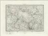
Bradford (Outline) - OS One-Inch Revised New Series
1 : 63360 Topographic maps Ordnance Survey Ordnance Survey
Bradford (Hills) - OS One-Inch Revised New Series
1 : 63360 Topographic maps Ordnance Survey Ordnance Survey
The County of York Survey'd in MDCCLXVII, VIII, IX, and MDCCLXX
London : T. Jefferys
Leeds and Bradford - OS One-Inch Map
1 : 63360 Topographic maps Ordnance Survey Ordnance Survey
Leeds Carriers' Warehouse District: Key Plan
1 : 126720 This "key plan" indicates coverage of the Goad 1896 series of fire insurance maps of Leeds that were originally produced to aid insurance companies in assessing fire risks. The building footprints, their use (commercial, residential, educational, etc.), the number of floors and the height of the building, as well as construction materials (and thus risk of burning) and special fire hazards (chemicals, kilns, ovens) were documented in order to estimate premiums. Names of individual businesses, property lines, and addresses were also often recorded. Together these maps provide a rich historical shapshot of the commercial activity and urban landscape of towns and cities at the time. The British Library holds a comprehensive collection of fire insurance plans produced by the London-based firm Charles E. Goad Ltd. dating back to 1885. These plans were made for most important towns and cities of the British Isles at the scales of 1:480 (1 inch to 40 feet), as well as many foreign towns at 1:600 (1 inch to 50 feet). Chas E Goad Limited Chas E Goad Limited
Harrogate, Sheet 6 - Bartholomew's "Half Inch to the Mile Maps" of England & Wales
1 : 126720 Topographic maps Bartholomew, John George John Bartholomew & Co
Sheets 49-50. (Cary's England, Wales, and Scotland).
1 : 360000 Cary, John, ca. 1754-1835

Lancashire
This map of Lancashire dates from 1598 and is by the cartographer and antiquarian William Smith. Smith was Rouge Dragon at the College of Heralds/College of Arms, an institution that specialised in genealogical work, increasingly more so during the Elizabethan age as the gentry class rose in importance. The Rouge Dragon is the name of one of the Pursuivants, a heraldic officer attendant on the heralds, often attached to a particular nobleman, named so because of their badges. The prominent coat of arms on this plan reveals Smith's heraldic interests. In 1588, Smith completed "The Particuler Description of England. With the portratures of certaine of the cheiffest citties & townes.1588". This work consisted of drawings of English cities and towns in a traditional birds eye view style, and drawings amalgamating bird's eye view and plan. In the years 1602-03, William Smith anonymously published maps of Chester, Essex, Hertfordshire Lancashire, (for which this may be preparatory work) Leicester, Norfolk, Northamptonshire, Staffordshire, Suffolk, Surrey, Warwickshire and Worcester. These were probably engraved in Amsterdam and were intended to form sheets of a new atlas. After the publication of Saxton’s county maps in the 1570s, cartographers attempted to improve on Saxton’s atlas and replicate its success. Unfortunately for Smith another cartographer, John Speed, was also preparing county maps at this time and competition proved too great, Speed being the victor. Here the ‘Countie stone’ is marked and labelled at the boundary point which separates Lancashire and Westmorland. A panel of text at bottom right provides a description of the County of Lancashire and Duchy of Lancaster. Smith, William
Ducatus Eboracensis Pars Borealis = The Northridinge of Yorkshire
1 : 250000 [Amstelodami] : [apud Joannem Janssonium]
Dvcatvs Eboracensis pars occidentalis
1 Karte : Kupferdruck ; 39 x 47 cm Valck; Schenk venundantur â Gerardo Valk et Petro Schenk
Dvcatvs Eboracensis pars occidentalis
1 Karte : Kupferdruck ; 37 x 48 cm Blaeu Joan Blaeu
DVCATVS | EBORACENSIS | PARS BOREALIS | THE NORTHRIDING | OF YORK SHIRE.
[Amsterdam : Joan Blaeu]
Ducatus Eboracensis Pars Borealis The Northriding Of York Shire. [Karte], in: Le théâtre du monde, ou, Nouvel atlas contenant les chartes et descriptions de tous les païs de la terre, Bd. 4, S. 394.
1 Karte aus Atlas Blaeu, Willem Janszoon und Blaeu, Joan Blaeu, Willem Janszoon
Ducatus Eboracensis Pars Borealis The Northriding Of York Shire. [Karte], in: Theatrum orbis terrarum, sive, Atlas novus, Bd. 4, S. 458.
1 Karte aus Atlas Blaeu, Joan Blaeu, Willem Janszoon
Ducatus Eboracensis Pars Borealis The Northriding Of York Shire. [Karte], in: Theatrum orbis terrarum, sive, Atlas novus, Bd. 4, S. 458.
1 Karte aus Atlas Blaeu, Joan Blaeu, Willem Janszoon
Ducatus Eboracensis Pars Borealis. The Northridinge of Yorkeshire. [Karte], in: Novus atlas absolutissimus, Bd. 8, S. 43.
1 Karte aus Atlas Janssonius Offizin
Lancastria Palatinatus anglis Lancaster & Lancas Shire
1 : 290000 Amstelodami : apud Joannem Janssonium
DVCATVS | EBORACENSIS | PARS OCCIDENTALIS; | THE WESTRIDING OF | YORKE SHIRE.
[Amsterdam : Joan Blaeu]