Maps of Wiltshire
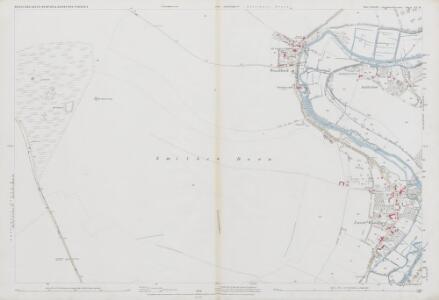
Wiltshire LX.14 (includes: Durnford; South Newton; Woodford) - 25 Inch Map
1 : 2500 Topographic maps Ordnance Survey Ordnance Survey
Wiltshire LX.14 (includes: Durnford; South Newton; Woodford) - 25 Inch Map
1 : 2500 Topographic maps Ordnance Survey Ordnance Survey
Wiltshire LX.14 (includes: Durnford; South Newton; Woodford) - 25 Inch Map
1 : 2500 Topographic maps Ordnance Survey Ordnance Survey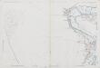
Wiltshire LX.14 (includes: Durnford; South Newton; Woodford) - 25 Inch Map
1 : 2500 Topographic maps Ordnance Survey Ordnance Survey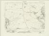
Wiltshire LX.SW - OS Six-Inch Map
1 : 10560 Topographic maps Ordnance Survey Ordnance Survey
Wiltshire LX.SW - OS Six-Inch Map
1 : 10560 Topographic maps Ordnance Survey Ordnance Survey
Wiltshire LX - OS Six-Inch Map
1 : 10560 Topographic maps Ordnance Survey Ordnance Survey
SU13 - OS 1:25,000 Provisional Series Map
1 : 25000 Topographic maps Ordnance Survey Ordnance Survey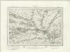
Salisbury (Outline) - OS One-Inch Revised New Series
1 : 63360 Topographic maps Ordnance Survey Ordnance Survey
Salisbury (Hills) - OS One-Inch Revised New Series
1 : 63360 Topographic maps Ordnance Survey Ordnance Survey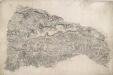
Berwick St. John
Small red crosses at Baverstoke, at the top centre, and Et Knoyle, at the top left,mark observation points used by the surveyor to plot topographical details and measure distances. The draughtsman has faithfully recorded the relative relief of the hills and indicated areas of woodland, using various shades of green to distinguish woods from grassland. The ancient circular earthworks of Chiselbury are marked by concentric rings on White Sheet Hill, in the centre of the drawing.
Salisbury
1 : 31680 This drawing is rich in archaeological sites, among them the prehistoric monument known as Stonehenge. Situated on Salisbury Plain, it is the most celebrated megaithic monument in England. The iron-age hillfort of Old Sarum is also marked. A castle and cathedral were built on its earthworks during the 12th century, but abandoned when a new cathedral was built a mile and a half away - the foundation of the modern city of Salisbury. The red line extending from Old Sarum to Beacon Hill is the baseline for the triangulation of the area. Several other archaeological sites are marked: the iron-age hillforts at Vispasians Camp, Ogbury Camp and Clorus's Camp. Crocker, Edmund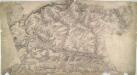
Warminster
1 : 31680 Although this drawing was surveyed six years before the obligatory inclusion of archaeological sites on drawings, several are featured. The most famous of these is Stonehenge, to the right of the drawing. Ancient camps, earthworks, castles and grave mounds ('tumuli') pepper the area, indicated by concentric shapes and a title in neat script. Their inclusion reveals the meticulous nature of the survey. To the right of the drawing, opposite Wishford, a trigonometrical station is indicated by a dot within a circle (annotated 'Col. Mudge's station' - Major-General William Mudge was Superintendent of the Ordnance Survey). This station denotes a point from which angular measurements were taken. In the right hand margin of the drawing a point titled "End of Base" marks the end of the Salisbury Plain baseline: an important measurement allowing for the triangulation of the area. Crocker, Edmund
Dorset Shire, 3
2 Blätter : 109 x 45 cm s.n.
Salisbury - OS One-Inch Map
1 : 63360 Topographic maps Ordnance Survey Ordnance Survey
Cary's Improved Map of England and Wales
Cary, George, & Cary, John London : G. & J. Cary
An improved map of Wilt Shire
1 Karte : Kupferdruck ; 52 x 68 cm Bowen; Tinney sold by I. Tinney at the Golden Lion in Fleet street
Wiltonia sive comitatvs Wiltoniensis; anglis Wil Shire
1 Karte : Kupferdruck ; 40 x 48 cm Blaeu Joan Blaeu
New Forrest & Isle of Wight, Sheet 33 - Bartholomew's "Half Inch to the Mile Maps" of England & Wales
1 : 126720 Topographic maps Bartholomew, John George John Bartholomew & Co
Wiltonia sive Comitatus Wiltoniensis anglis Wil Shire
1 : 210000 Amstelodami : apud Joannem Janssonium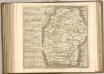

Hantonia sive Sovthantonensis comitatvs vulgo Hant-shire
1 Karte : Kupferdruck ; 40 x 48 cm Blaeu Joan Blaeu
WILTONIAE Comitatus
This is a map of Wiltshire by Christopher Saxton which dates from 1576. It forms part of an atlas that belonged to William Cecil Lord Burghley, Elizabeth I’s Secretary of State. Burghley used this atlas to illustrate domestic matters. This map is actually a proof copy of one which forms part of Christopher Saxton’s Atlas of England and Wales. This atlas was first published as a whole in 1579. It consists of 35 coloured maps depicting the counties of England and Wales. The atlas is of great significance to British cartography as it set a standard of cartographic representation in Britain and the maps remained the basis for English county mapping, with few exceptions, until after 1750. During the reign of Elizabeth I, map use became more common, with many government matters referring to increasingly accurate maps with consistent scales and symbols, made possible by advances in surveying techniques. Illustrating the increasing use of maps in government matters, Lord Burghley, who had been determined to have England and Wales mapped in detail from the 1550s, selected the cartographer Christopher Saxton to produce a detailed and consistent survey of the country. The financier of the project was Thomas Seckford Master of Requests at the Court of Elizabeth I, whose arms appear, along with the royal crest on each map .Lord Burghley has added several place names to the map. This map was engraved by Remigius Hogenbergius, one of a team of seven English and Flemish engravers employed to produce the copper plates for the atlas. Saxton, Christopher Hogenbergius, Remigius
COMITATVS | DORCESTRIA, | sive | DORSETTIA; | Vulgo Anglice | DORSET SHIRE.
[Amsterdam : Joan Blaeu]
DORCESTRIAE Comitatus
This is a map of Dorset by Christopher Saxton, datingfrom 1575. It forms part of an atlas that belonged to William Cecil Lord Burghley, Elizabeth I’s Secretary of State. Burghley used this atlas to illustrate domestic matters. This map is actually a proof copy of one which forms part of Christopher Saxton’s Atlas of England and Wales. This atlas was first published as a whole in 1579. It consists of 35 coloured maps depicting the counties of England and Wales. The atlas is of great significance to British cartography as it set a standard of cartographic representation in Britain and the maps remained the basis for English county mapping, with few exceptions, until after 1750. During the reign of Elizabeth I map use became more common, with many government matters referring to increasingly accurate maps with consistent scales and symbols, made possible by advances in surveying techniques. Illustrating the increasing use of maps in government matters, Lord Burghley, who had been determined to have England and Wales mapped in detail from the 1550s, selected the cartographer Christopher Saxton to produce a detailed and consistent survey of the country. The financier of the project was Thomas Seckford, Master of Requests at the Court of Elizabeth I, whose arms appear, along with the royal crest, on each map. Lord Burghley added several place names. In the lower margin there are notes concerning 'Dangerous places for landing of men in the county'. These notes were probably written by an assistant of Lord Burghley and show the concern felt about the south coasts vulnerability to invasion. Due to the presence of a Protestant Queen in the form of Elizabeth I, England was under threat from a catholic crusade from Philip II of Spain. This threat culminated in the events of the Spanish Armada in 1588. Saxton, Christopher William Cecil, Lord Burghley
WILTONIA | sive | COMITATVS WILTONI- | ENSIS; Anglis | WIL SHIRE.
[Amsterdam : Joan Blaeu]
DORCESTRIAE
This map of Dorset is from the 1583 edition of the Saxton atlas of England and Wales. This atlas was first published as a whole in 1579. It consists of 35 coloured maps depicting the counties of England and Wales. The atlas is of great significance to British cartography as it set a standard of cartographic representation in Britain and the maps remained the basis for English county mapping, with few exceptions, until after 1750. During the reign of Elizabeth I map use became more common, with many government matters referring to increasingly accurate maps with consistent scales and symbols, made possible by advances in surveying techniques. Illustrating the increasing used of maps in government matters, Lord Burghley, Elizabeth I’s Secretary of State, who had been determined to have England and Wales mapped in detail from the 1550s, selected the cartographer Christopher Saxton to produce a detailed and consistent survey of the country. The financier of the project was Thomas Seckford Master of Requests at the Court of Elizabeth I, whose arms appear, along with the royal crest, on each map. Here the strap work cartouche is mounted by the Elizabethan coat of arms. The Seckford arms of appear at the bottom of the map, adjacent to the decorative scale bar which houses Saxton’s name. The adjacent counties are named but lack any internal detail, recording only the path of rivers that cross county boundaries. Relief, in the form of uniform rounded representations of hills, is the main topographical feature presented in the maps. Rather than provide a scientific representation of relative relief these give a general impression of the lie of the land. Settlements and notable buildings are also recorded pictorially; a small building with a spire represents a village, while more important towns are indicated by groups of buildings. Here Portland castle is marked by a castle symbol of two connected towers. Rivers, streams, parks and woodlands are also depicted carefully. Woods are shown by small tree-symbols, with clusters representing forests, and parklands enclosed with ring fences. Great decorative effect is provided by the detailed images of ships in the stippled sea. Saxton, Christopher Ryther, Augustine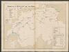
Comitatus Dorcestria, sive Dorsettia; Vulgo Anglice Dorset Shire. [Karte], in: Le théâtre du monde, ou, Nouvel atlas contenant les chartes et descriptions de tous les païs de la terre, Bd. 4, S. 127.
1 Karte aus Atlas Blaeu, Willem Janszoon und Blaeu, Joan Blaeu, Willem Janszoon
Comitatus Dorcestria, sive Dorsettia; Vulgo Anglice Dorset Shire. [Karte] , in: Theatrum orbis terrarum, sive, Atlas novus, Bd. 4, S. 143.
1 Karte aus Atlas Blaeu, Joan Blaeu, Willem Janszoon