Maps of Bath and North East Somerset
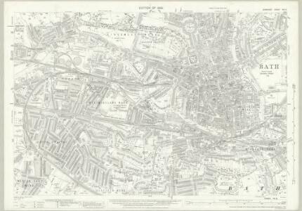
Somerset XIV.5 (includes: Bath) - 25 Inch Map
1 : 2500 Topographic maps Ordnance Survey Ordnance Survey
Somerset XIV.5 (includes: Bath) - 25 Inch Map
1 : 2500 Topographic maps Ordnance Survey Ordnance Survey
Somerset XIV.5 (includes: Bath) - 25 Inch Map
1 : 2500 Topographic maps Ordnance Survey Ordnance Survey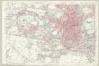
Somerset XIV.5 (includes: Bath) - 25 Inch Map
1 : 2500 Topographic maps Ordnance Survey Ordnance Survey
Insurance Plan of Bath: Key Plan
1 : 3600 This "key plan" indicates coverage of the Goad 1902 series of fire insurance maps of Bath that were originally produced to aid insurance companies in assessing fire risks. The building footprints, their use (commercial, residential, educational, etc.), the number of floors and the height of the building, as well as construction materials (and thus risk of burning) and special fire hazards (chemicals, kilns, ovens) were documented in order to estimate premiums. Names of individual businesses, property lines, and addresses were also often recorded. Together these maps provide a rich historical shapshot of the commercial activity and urban landscape of towns and cities at the time. The British Library holds a comprehensive collection of fire insurance plans produced by the London-based firm Charles E. Goad Ltd. dating back to 1885. These plans were made for most important towns and cities of the British Isles at the scales of 1:480 (1 inch to 40 feet), as well as many foreign towns at 1:600 (1 inch to 50 feet). Chas E Goad Limited Chas E Goad Limited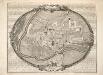
PLAN OF THE CITY OF BATH
This map of Bath was engraved by John Pine from an original survey made by John Wood, the architect responsible for many of the city’s buildings. Not surprisingly, therefore, the accompanying text extols the virtues of the city: "The Buildings are of Free Stone erected in a Magnificent manner. There are pleasant Walks and every thing that renders the City Entertaining and Delightful. And as of late many Familys of Distinction have settled here, so the City is now become one of the most Polite and Agreeable Places in Europe." John Pine was a distinguished engraver, famous in his own day for his illustrated edition of the works of Horace, the Ancient Roman poet. Wood, John Pine, John
Insurance Plan of Bath: sheet 8-2
1 : 480 This detailed 1930 plan of Bath is one of a series of two sheets in an atlas originally produced to aid insurance companies in assessing fire risks. The building footprints, their use (commercial, residential, educational, etc.), the number of floors and the height of the building, as well as construction materials (and thus risk of burning) and special fire hazards (chemicals, kilns, ovens) were documented in order to estimate premiums. Names of individual businesses, property lines, and addresses were also often recorded. Together these maps provide a rich historical shapshot of the commercial activity and urban landscape of towns and cities at the time. The British Library holds a comprehensive collection of fire insurance plans produced by the London-based firm Charles E. Goad Ltd. dating back to 1885. These plans were made for most important towns and cities of the British Isles at the scales of 1:480 (1 inch to 40 feet), as well as many foreign towns at 1:600 (1 inch to 50 feet). Chas E Goad Limited Chas E Goad Limited
Insurance Plan of Bath: sheet 2
1 : 480 This detailed 1902 plan of Bath is one of a series of seven sheets in an atlas originally produced to aid insurance companies in assessing fire risks. The building footprints, their use (commercial, residential, educational, etc.), the number of floors and the height of the building, as well as construction materials (and thus risk of burning) and special fire hazards (chemicals, kilns, ovens) were documented in order to estimate premiums. Names of individual businesses, property lines, and addresses were also often recorded. Together these maps provide a rich historical shapshot of the commercial activity and urban landscape of towns and cities at the time. The British Library holds a comprehensive collection of fire insurance plans produced by the London-based firm Charles E. Goad Ltd. dating back to 1885. These plans were made for most important towns and cities of the British Isles at the scales of 1:480 (1 inch to 40 feet), as well as many foreign towns at 1:600 (1 inch to 50 feet). Chas E Goad Limited Chas E Goad Limited
Insurance Plan of Bath: sheet 3
1 : 480 This detailed 1902 plan of Bath is one of a series of seven sheets in an atlas originally produced to aid insurance companies in assessing fire risks. The building footprints, their use (commercial, residential, educational, etc.), the number of floors and the height of the building, as well as construction materials (and thus risk of burning) and special fire hazards (chemicals, kilns, ovens) were documented in order to estimate premiums. Names of individual businesses, property lines, and addresses were also often recorded. Together these maps provide a rich historical shapshot of the commercial activity and urban landscape of towns and cities at the time. The British Library holds a comprehensive collection of fire insurance plans produced by the London-based firm Charles E. Goad Ltd. dating back to 1885. These plans were made for most important towns and cities of the British Isles at the scales of 1:480 (1 inch to 40 feet), as well as many foreign towns at 1:600 (1 inch to 50 feet). Chas E Goad Limited Chas E Goad Limited
Insurance Plan of Bath: sheet 4
1 : 480 This detailed 1902 plan of Bath is one of a series of seven sheets in an atlas originally produced to aid insurance companies in assessing fire risks. The building footprints, their use (commercial, residential, educational, etc.), the number of floors and the height of the building, as well as construction materials (and thus risk of burning) and special fire hazards (chemicals, kilns, ovens) were documented in order to estimate premiums. Names of individual businesses, property lines, and addresses were also often recorded. Together these maps provide a rich historical shapshot of the commercial activity and urban landscape of towns and cities at the time. The British Library holds a comprehensive collection of fire insurance plans produced by the London-based firm Charles E. Goad Ltd. dating back to 1885. These plans were made for most important towns and cities of the British Isles at the scales of 1:480 (1 inch to 40 feet), as well as many foreign towns at 1:600 (1 inch to 50 feet). Chas E Goad Limited Chas E Goad Limited
Insurance Plan of Bath: sheet 5
1 : 480 This detailed 1902 plan of Bath is one of a series of seven sheets in an atlas originally produced to aid insurance companies in assessing fire risks. The building footprints, their use (commercial, residential, educational, etc.), the number of floors and the height of the building, as well as construction materials (and thus risk of burning) and special fire hazards (chemicals, kilns, ovens) were documented in order to estimate premiums. Names of individual businesses, property lines, and addresses were also often recorded. Together these maps provide a rich historical shapshot of the commercial activity and urban landscape of towns and cities at the time. The British Library holds a comprehensive collection of fire insurance plans produced by the London-based firm Charles E. Goad Ltd. dating back to 1885. These plans were made for most important towns and cities of the British Isles at the scales of 1:480 (1 inch to 40 feet), as well as many foreign towns at 1:600 (1 inch to 50 feet). Chas E Goad Limited Chas E Goad Limited
Insurance Plan of Bath: sheet 6-1
1 : 480 This detailed 1902 plan of Bath is one of a series of seven sheets in an atlas originally produced to aid insurance companies in assessing fire risks. The building footprints, their use (commercial, residential, educational, etc.), the number of floors and the height of the building, as well as construction materials (and thus risk of burning) and special fire hazards (chemicals, kilns, ovens) were documented in order to estimate premiums. Names of individual businesses, property lines, and addresses were also often recorded. Together these maps provide a rich historical shapshot of the commercial activity and urban landscape of towns and cities at the time. The British Library holds a comprehensive collection of fire insurance plans produced by the London-based firm Charles E. Goad Ltd. dating back to 1885. These plans were made for most important towns and cities of the British Isles at the scales of 1:480 (1 inch to 40 feet), as well as many foreign towns at 1:600 (1 inch to 50 feet). Chas E Goad Limited Chas E Goad Limited
Insurance Plan of Bath: sheet 9
1 : 480 This detailed 1930 plan of Bath is one of a series of two sheets in an atlas originally produced to aid insurance companies in assessing fire risks. The building footprints, their use (commercial, residential, educational, etc.), the number of floors and the height of the building, as well as construction materials (and thus risk of burning) and special fire hazards (chemicals, kilns, ovens) were documented in order to estimate premiums. Names of individual businesses, property lines, and addresses were also often recorded. Together these maps provide a rich historical shapshot of the commercial activity and urban landscape of towns and cities at the time. The British Library holds a comprehensive collection of fire insurance plans produced by the London-based firm Charles E. Goad Ltd. dating back to 1885. These plans were made for most important towns and cities of the British Isles at the scales of 1:480 (1 inch to 40 feet), as well as many foreign towns at 1:600 (1 inch to 50 feet). Chas E Goad Limited Chas E Goad Limited
Insurance Plan of Bath: sheet 7-2
1 : 480 This detailed 1902 plan of Bath is one of a series of seven sheets in an atlas originally produced to aid insurance companies in assessing fire risks. The building footprints, their use (commercial, residential, educational, etc.), the number of floors and the height of the building, as well as construction materials (and thus risk of burning) and special fire hazards (chemicals, kilns, ovens) were documented in order to estimate premiums. Names of individual businesses, property lines, and addresses were also often recorded. Together these maps provide a rich historical shapshot of the commercial activity and urban landscape of towns and cities at the time. The British Library holds a comprehensive collection of fire insurance plans produced by the London-based firm Charles E. Goad Ltd. dating back to 1885. These plans were made for most important towns and cities of the British Isles at the scales of 1:480 (1 inch to 40 feet), as well as many foreign towns at 1:600 (1 inch to 50 feet). Chas E Goad Limited Chas E Goad Limited
Insurance Plan of Bath: sheet 7-1
1 : 480 This detailed 1902 plan of Bath is one of a series of seven sheets in an atlas originally produced to aid insurance companies in assessing fire risks. The building footprints, their use (commercial, residential, educational, etc.), the number of floors and the height of the building, as well as construction materials (and thus risk of burning) and special fire hazards (chemicals, kilns, ovens) were documented in order to estimate premiums. Names of individual businesses, property lines, and addresses were also often recorded. Together these maps provide a rich historical shapshot of the commercial activity and urban landscape of towns and cities at the time. The British Library holds a comprehensive collection of fire insurance plans produced by the London-based firm Charles E. Goad Ltd. dating back to 1885. These plans were made for most important towns and cities of the British Isles at the scales of 1:480 (1 inch to 40 feet), as well as many foreign towns at 1:600 (1 inch to 50 feet). Chas E Goad Limited Chas E Goad Limited
Insurance Plan of Bath: sheet 8-1
1 : 480 This detailed 1930 plan of Bath is one of a series of two sheets in an atlas originally produced to aid insurance companies in assessing fire risks. The building footprints, their use (commercial, residential, educational, etc.), the number of floors and the height of the building, as well as construction materials (and thus risk of burning) and special fire hazards (chemicals, kilns, ovens) were documented in order to estimate premiums. Names of individual businesses, property lines, and addresses were also often recorded. Together these maps provide a rich historical shapshot of the commercial activity and urban landscape of towns and cities at the time. The British Library holds a comprehensive collection of fire insurance plans produced by the London-based firm Charles E. Goad Ltd. dating back to 1885. These plans were made for most important towns and cities of the British Isles at the scales of 1:480 (1 inch to 40 feet), as well as many foreign towns at 1:600 (1 inch to 50 feet). Chas E Goad Limited Chas E Goad Limited
Insurance Plan of Bath: sheet 7-3
1 : 480 This detailed 1902 plan of Bath is one of a series of seven sheets in an atlas originally produced to aid insurance companies in assessing fire risks. The building footprints, their use (commercial, residential, educational, etc.), the number of floors and the height of the building, as well as construction materials (and thus risk of burning) and special fire hazards (chemicals, kilns, ovens) were documented in order to estimate premiums. Names of individual businesses, property lines, and addresses were also often recorded. Together these maps provide a rich historical shapshot of the commercial activity and urban landscape of towns and cities at the time. The British Library holds a comprehensive collection of fire insurance plans produced by the London-based firm Charles E. Goad Ltd. dating back to 1885. These plans were made for most important towns and cities of the British Isles at the scales of 1:480 (1 inch to 40 feet), as well as many foreign towns at 1:600 (1 inch to 50 feet). Chas E Goad Limited Chas E Goad Limited
Insurance Plan of Bath: sheet 6-2
1 : 480 This detailed 1902 plan of Bath is one of a series of seven sheets in an atlas originally produced to aid insurance companies in assessing fire risks. The building footprints, their use (commercial, residential, educational, etc.), the number of floors and the height of the building, as well as construction materials (and thus risk of burning) and special fire hazards (chemicals, kilns, ovens) were documented in order to estimate premiums. Names of individual businesses, property lines, and addresses were also often recorded. Together these maps provide a rich historical shapshot of the commercial activity and urban landscape of towns and cities at the time. The British Library holds a comprehensive collection of fire insurance plans produced by the London-based firm Charles E. Goad Ltd. dating back to 1885. These plans were made for most important towns and cities of the British Isles at the scales of 1:480 (1 inch to 40 feet), as well as many foreign towns at 1:600 (1 inch to 50 feet). Chas E Goad Limited Chas E Goad Limited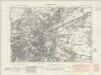
Somerset XIV.NW - OS Six-Inch Map
1 : 10560 Topographic maps Ordnance Survey Ordnance Survey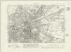
Somerset XIV.NW - OS Six-Inch Map
1 : 10560 Topographic maps Ordnance Survey Ordnance Survey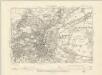
Somerset XIV.NW - OS Six-Inch Map
1 : 10560 Topographic maps Ordnance Survey Ordnance Survey
Somerset XIV.NW - OS Six-Inch Map
1 : 10560 Topographic maps Ordnance Survey Ordnance Survey
ST76 - OS 1:25,000 Provisional Series Map
1 : 25000 Topographic maps Ordnance Survey Ordnance Survey
Bath (Hills) - OS One-Inch Revised New Series
1 : 63360 Topographic maps Ordnance Survey Ordnance Survey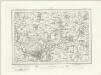
Bath (Outline) - OS One-Inch Revised New Series
1 : 63360 Topographic maps Ordnance Survey Ordnance Survey
Frome
This drawing highlights Bath and the River Avon. Major communication routes are coloured yellow/buff, according to military cartographic convention. Shading and 'hachuring' denote relief and give an overall impression of the undulating landscape. The Somerset Coal Canal is clearly visible leading into Bath. It was established by Act of Parliament in 1794 and welcomed by the mine owners of north Somerset as a cheaper way of transporting coal to Bath and the surrounding areas, curbing fears of an influx of Welsh coal. The canal was one of the most successful in the country, carrying over 100,000 tons of coal per year. That success was to be checked, however, by the expansion of the local rail network, in particular, the opening of the line between Radstock and Frome, which hastened the canal's closure in 1898. At the time of this survey, the canal was fully operational. Crocker, Edmund
Frome - OS One-Inch Map
1 : 63360 Topographic maps Ordnance Survey Ordnance Survey
Bristol and Stroud - OS One-Inch Map
1 : 63360 Topographic maps Ordnance Survey Ordnance Survey
Cary's Improved Map of England and Wales
Cary, George, & Cary, John London : G. & J. Cary
An improved map of Wilt Shire
1 Karte : Kupferdruck ; 52 x 68 cm Bowen; Tinney sold by I. Tinney at the Golden Lion in Fleet street