Maps of powiat bolesławiecki
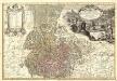
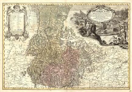
Princip. Silesiae Iavoriensis in IV. Circulos, Iaver, Hirschberg, Lemberg und Bvmtzlav divisi ac.
1 : 150000 Mollova mapová sbírka Wieland, Johann Wolfgang Homann, Johann Baptista - dědici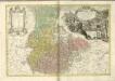
PRINCIP. SILESIAE IAVORIENSIS in IV. CIRCULOS, IAVER, HIRSCHBERG, LEMBERG und BVNTZLAV DIVISI
1 : 150000 Jelení Hora-oblast (Polsko) Wieland, Johann Wolfgang Schubarth, Matthaeus ab Hered. Homannianis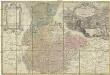
Princip. Silesiae Iavoriensis in IV. circulos, Iaver, Hirschberg, Lemberg und Bvntzlau divisi ac a I. W. Wieland
1 : 150000 Jawor (Polsko) Schubart, Mathaeum Hered. Homannianis
DVCATVS | SILESIÆ | IAVRANI | DELINEATIO
Auctore Friderico Kuhnovio | Bolcol. Siles. Exc. I. Blaeuw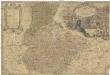
Principatvs Silesiae Iavoricensis in 4 circulos, Iaver, Hirschberg, Lemberg und Bvntzlav divisi
1 : 150000 Bolesławiec (Polsko) Wieland, Johann Wolfgang Schubarth, Matthäus Homannianos Heredes
Das Land an der Flüssen Neisse, Queis, Bober, Katzbach und der wüthenden Neisse
1 : 440000 Kaczawa (Polsko)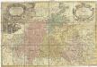
Principatvs Silesiae Schwidnicensis
1 : 128000 Svídnice-oblast (Polsko) Wieland, Johann Wolfgang Schubarth, Matthäus Hered. Homannianis
Ducatuum Silesiae Svidnicensis et Iavraviensis Delineatio :
1 : 208000 Mollova mapová sbírka Köhler, Gottfried Posch, C.
Generální mapa Protektorátu Čechy a Morava


118. Liegnitz, uit: Topographische Uebersichtskarte des Deutschen Reiches / herausgegeben v. d. Kartogr. Abt. d. Königl. Preuß. Landesaufnahme
1 : 200000 titelvariant: Topogr. Übersichtskarte des Deutschen Reiches; Annotatie: Titel boven bladen ook: Topogr. Übersichtskarte des Deutschen Reiches; Annotatie geografische gegevens: Op elk blad twee maatstokken: 10 Kilometer = 5,5 cm; 1 geogr. Meile = 3,6 cm; Legenda onder op elk blad Königlich Preußische Landesaufnahme. Kartographische Abtheilung [S.l : Königlich Preußische Landesaufnahme, Kartographische Abtheilung]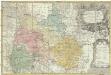
Principatvs Silesiae Lignicensis in suos circulos, tres nempe Lignicenses Goldbergensem, Haynavviensem et Lvbenensem divisi
1 : 100000 Lehnice (Polsko) Wieland, Johann Wolfgang Schubarth, Matthäus Homannianos Heredes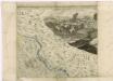
Müllerova mapa Čech
1 : 132000
Liegnitz-Hirschberg (Riesengebirge)
1 : 100000 Jelení Hora-oblast (Polsko) Reichsamt für Landesaufnahme
150 Hirschberg, uit: Topographische Special-Karte von Deutschland (von Central-Europa) / begründet von D.G. Reymann ; [entworfen und gezeichn. von Heinrich Berghaus... [et al.]]
1 : 200000 Annotatie: Lit.: Daniel Gottlob Reymann und die "Topographische Special-Karte von Deutschland" / von Wolfgang Scharfe, in: Kartographische Nachrichten, 39 (1989), Heft I, p. 1-10; Handgeschreven titel: Reymann's Deutschland : 24 Sectionen: Jena, Penig, Dresden, Zittau, Hirschberg, Breslau, Brieg, Andernach, Coblenz, Giessen, Fulda, Schleusingen, Plauen, Zwickau, Teplitz, Jung Bunzlau, Hohenelbe, Glatz, Neisse, Simmern, Prag, Luxemburg, Birkenfeld; Aanwezig: 23 bladen Reymann, Daniel Gottlob; Berghaus, Heinrich [Berlin : 2. Departement des Kriegsministeriums, Bureau für Plan- und Kartenzeichnung]
Karte des Riesengebirges
1 : 200000 Krkonoše (Česko a Polsko : pohoří : oblast) Reymann, Gottlob Daniel C. Flemming
Ducatus Silesiae Ligniciensis. [Karte], in: Novus atlas absolutissimus, Bd. 2, S. 267.
1 Karte aus Atlas Janssonius Offizin
Wegekarte vom Riesen- und Iser-Gebirge
1 : 150000 Jizerské hory-oblast (Česko a Polsko) Straube, Julius Geograph. Inst. u. Landkarten-Verlag v. Jul. Straube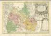


DVCATVS | SILESIÆ | LIGNICIENSIS
Auctore | Iona Sculteto Sprotta Silesio Amstelædami J. Blaeu excud.
Ducatus Silesiae Ligniciensis
1 : 170000 Mollova mapová sbírka Aveele, Johannes van den Schenk, Peter I
Dvcatvs Silesiae Ligniciensis
1 : 160000 Mollova mapová sbírka Scultetus, Johannes Blaeu, Joan I.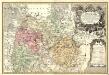
Principatvs Silesiae in suos circulos, tres nempe Lignicenses Goldbergensem, Haynavviensem et Lvbenensem divisii
1 : 100000 Mollova mapová sbírka Wieland, Johann Wolfgang Homann, Johann Baptista - dědici
Special-Carte des Fürstenthums Liegnitz in Nieder-Schlesien
Lehnice-oblast (Polsko) Wieland, Johann Wolfgang Schleuen, Johann David Schleuen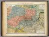
Spezial-Karte vom Riesen-Gebirge.
1 : 200000 Berghaus, Heinrich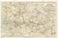
Straubes farbige Wegekarte vom Jeschken- Iser- u. Riesengebirge
1 : 120000 Adršpach-oblast (Česko) Straube, Julius Jul. Staube
Special-Carte des Fürstenthums Liegnitz in Nieder Schlesien
1 : 230000 Mollova mapová sbírka Schleuen, Johann David