Maps of Rhein-Hunsrück-Kreis

Le Flambeau de la Guerre Allumee au Rhin
Mollova mapová sbírka Delisle, Guillaume Schenk, Peter II
179 Simmern, uit: Topographische Special-Karte von Deutschland (von Central-Europa) / begründet von D.G. Reymann ; [entworfen und gezeichn. von Heinrich Berghaus... [et al.]]
1 : 200000 Annotatie: Lit.: Daniel Gottlob Reymann und die "Topographische Special-Karte von Deutschland" / von Wolfgang Scharfe, in: Kartographische Nachrichten, 39 (1989), Heft I, p. 1-10; Handgeschreven titel: Reymann's Deutschland : 24 Sectionen: Jena, Penig, Dresden, Zittau, Hirschberg, Breslau, Brieg, Andernach, Coblenz, Giessen, Fulda, Schleusingen, Plauen, Zwickau, Teplitz, Jung Bunzlau, Hohenelbe, Glatz, Neisse, Simmern, Prag, Luxemburg, Birkenfeld; Aanwezig: 23 bladen Reymann, Daniel Gottlob; Berghaus, Heinrich [Berlin : 2. Departement des Kriegsministeriums, Bureau für Plan- und Kartenzeichnung]
Montroyal :
1 : 270000 Mollova mapová sbírka Person, Nikolaus Person, Nicolas
[28] Sect. Berncastel, uit: Geologische Karte der Rheinprovinz und der Provinz Westphalen / ausgeführt durch H. von Dechen
1 : 80000 titelvariant: Dechen's geologische Karte vom Rheinland und Westphalen; Annotatie: Titel op bladoverzicht; Incompleet Heinrich von Dechen Berlin : Schropp
Montroyal Sambt der Gegend auff 2 Stund.
1 : 150000 Mollova mapová sbírka Bodenehr, Gabriel Bodenehr, Gabriel
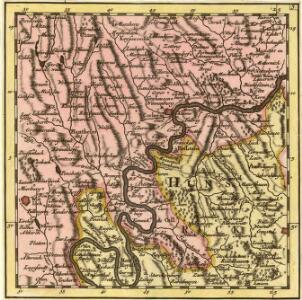
Ein Theil des Hundsrucks mit den angraenzenden Maynz u. Trierischen Laendern :
1 : 95000 Mollova mapová sbírka Homann, Johann Baptist Homann, Johann Baptista - dědici
Meßtischblatt 6010 : Kirchberg (Hunsrück), 1943
1 : 250000 Kirchberg (Hunsrück). - Aufn. 1905, hrsg. 1907, bericht. 1936, letzte Nachtr. 1940. - 1:25000. - [Berlin]: Reichsamt für Landesaufnahme, 1943. - 1 Kt.
Meßtischblatt 3432 : Sohren, 1914
1 : 250000 Sohren. - Hrsg. 1886, N[achtr. 19]14. - 1:25000. - [Berlin]: Preuss. Landesaufnahme, 1914. - 1 Kt.
Meßtischblatt 3432 : Sohren, 1909
1 : 250000 Sohren. - Aufn. 1885, hrsg. 1886, bericht. 1909. - 1:25000. - [Berlin]: Kgl. Preuss. Landesaufnahme, 1909. - 1 Kt.
Meßtischblatt 3432 : Sohren, 1886
1 : 250000 Sohren. - Aufn. 1885, hrsg. 1886. - 1:25000. - [Berlin]: Kgl. Preuss. Landesaufnahme, 1886. - 1 Kt.
Meßtischblatt 3431 : Bernkastel, 1914
1 : 250000 Bernkastel. - Aufn. 1885, hrsg. 1887, gedr. [19]14. - 1:25000. - [Berlin]: Kgl. Preuß. Landesaufnahme, 1914. - 1 Kt.
Meßtischblatt 3431 : Bernkastel, 1914
1 : 250000 Bernkastel. - Aufn. 1885, hrsg. 1887, gedr. [19]14. - 1:25000. - [Berlin]: Preuß. Landesaufnahme, 1914. - 1 Kt.
Meßtischblatt 3430 : Wittlich, 1887
1 : 250000 Wittlich. - Aufn. 1885. - 1:25000. - [Berlin]: Kgl. Preuss. Landesaufnahme, 1887. - 1 Kt.
Meßtischblatt 3402 : Kastellaun, 1903
1 : 250000 Kastellaun. - Aufn. 1901. - 1:25000. - [Berlin]: Kgl. Preuss. Landesaufnahme, 1903. - 1 Kt.
Meßtischblatt 3401 : Zell, 1888
1 : 250000 Zell. - Aufn. 1886. - 1:25000. - [Berlin]: Kgl. Preuss. Landesaufnahme, 1888. - 1 Kt.
Meßtischblatt 3400 : Alf, 1888
1 : 250000 Alf. - Aufn. 1886. - 1:25000. - [Berlin]: Kgl. Preuss. Landesaufnahme, 1888. - 1 Kt.
Meßtischblatt 3399 : Hasborn, 1888
1 : 250000 Hasborn. - Aufn. 1886. - 1:25000. - [Berlin]: Kgl. Preuss. Landesaufnahme, 1888. - 1 Kt.
Meßtischblatt 3364 : Dommershausen, 1903
1 : 250000 Dommershausen. - Aufn. 1901. - 1:25000. - [Berlin]: Kgl. Preuss. Landesaufnahme, 1903. - 1 Kt.
Meßtischblatt 3363 : Treis, 1888
1 : 250000 Treis. - Aufn. 1886. - 1:25000. - [Berlin]: Kgl. Preuss. Landesaufnahme, 1888. - 1 Kt.
Meßtischblatt 3362 : Cochem, 1887
1 : 250000 Cochem. - Aufn. 1886. - 1:25000. - [Berlin]: Kgl. Preuss. Landesaufnahme, 1887. - 1 Kt.
Meßtischblatt 3361 : Gillenfeld, 1914
1 : 250000 Gillenfeld. - Aufn. 1886, hrsg. 1888, gedr. [19]14. - 1:25000. - [Berlin]: Kgl. Preuss. Landesaufnahme, [19]14. - 1 Kt.
Meßtischblatt 3361 : Gillenfeld, 1888
1 : 250000 Gillenfeld. - Aufn. 1886. - 1:25000. - [Berlin]: Kgl. Preuss. Landesaufnahme, 1888. - 1 Kt.
Montroyal Und Umliegende Gegend in Grund.
1 : 55000 Mollova mapová sbírka Bodenehr, Gabriel Bodenehr, Gabriel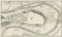
Mont-royal
Mollova mapová sbírka Bodenehr, Gabriel Bodenehr, Gabriel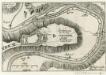
Letzte Delineation der Vestung Mont-Royal Ai. 1693.
1 : 20000 Mollova mapová sbírka Person, Nikolaus Person, Nicolas
Vallentz
Mollova mapová sbírka Merian, Matthaeus Merian, Matthäus
Meßtischblatt 3460 : Gemünden, 1907
1 : 250000 Gemünden. - Aufn. 1905. - 1:25000. - [Berlin]: Reichsamt für Landesaufnahme, 1907. - 1 Kt.
Meßtischblatt 3459 : Hottenbach, 1886
1 : 250000 Hottenbach. - Aufn. 1885. - 1:25000. - [Berlin]: Reichsamt für Landesaufnahme, 1886. - 1 Kt.
Meßtischblatt 3458 : Morbach, 1886
1 : 250000 Morbach. - Aufn. 1885. - 1:25000. - [Berlin]: Reichsamt für Landesaufnahme, 1886. - 1 Kt.
Meßtischblatt 3457 : Neumagen, 1934
1 : 250000 Neumagen. - Hrsg. 1886, bericht. 1909, einz. Nachtr. 1914, gedr. [19]34. - 1:25000. - [Berlin]: Reichsamt für Landesaufnahme, 1934. - 1 Kt.