Maps of Baden-Württemberg

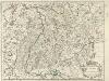
Tractvs Rhenanvs Svperior
1 : 810000 Mollova mapová sbírka Weigel, Christoph I. - vdova
Neueste Karte von Württemberg, Baden, Hohenzollern, die Rheinpfalz nebst den deutschen Reichslanden Elsass und Lothringen : zum Hand- und Comptoir-Gebrauch bearbeitet und namentlich mit Rücksicht auf Eisenbahnen als Reise- und Verkehrskarte angelegt
Baur, Carl Friedrich Wittwer
Hessen-Nassau, Groszherzogtum Hessen und Furstentum Waldeck
1 : 500000 Scobel, Albert
Abriss des Reinstroms
1 : 870000 Mollova mapová sbírka
Landgraviatus Alsatiae
1 : 340000 Alsasko (Francie) Homann, Johann Baptist Ioh. Baptista Homanno
Landgraviatus Alsatiae
1 : 340000 Alsasko (Francie) Homann, Johann Baptist J. B. Homann
Landgraviatus Alsatiae
1 : 340000 Alsasko (Francie) Homann, Johann Baptist Ioh. Baptista Homanno
Tabula Nova Particularis Provincie Rheni Superioris [Karte], in: Claudii Ptolemei viri Alexandrini mathematice discipline philosophi doctissimi geographie opus [...], S. 278.
1 Karte aus Atlas Waldseemüller, Martin [und Ptolemaeus, Claudius] Übelin, Georg
Mappa in qua Armisonum Martis Theatrum, ad Rhenum et Mosellam geographico stilo Exacte delineatur
1 : 1200000 Mollova mapová sbírka
Circulus Suevicus in quo sunt ducatus Wirtenbergensis
1 Karte : Kupferdruck ; 46 x 55 cm Bodenehr s.n.
Baden.
1 : 800000 Radefeld, Carl Christian Franz, 1788-1874
Circulus Suevicus in quo Ducatus Wirtenbergensis cum reliquis Statibus Et Provinciis curate designatus proponitur
Seutter, Matthäus Seutter
[54][54] Utriusque Alsatiae, Ducatus Dupontii, et Spirensis Episcopatus, uit: Atlas sive Descriptio terrarum orbis
Annotatie: Gedigitaliseerde versie. Amsterdam. Heiloo : Picturae (vervaardiger), 2015. tiff-bestand. Gedigitaliseerd: 07-01-2015; Origineel: Universiteitsbibliotheek Vrije Universiteit (XL.05127.-) ; Netherlands; Titelpagina ontbreekt Wit, Frederik de Amsterdam : Frederick de Wit
Pars summa, seu Australis Superioris Rheni Circuli;
1 : 650000 Mollova mapová sbírka Valk, Gerhard Valck, Gerard
Geographica Sueviæ universæ descriptio, 1
1 Blatt : Homännische Erben
Gross Herzogthum Baden
Grosser Hand-Atlas über alle Theile der Erde in 170 Karten Meyer, J. Verlag des Bibliographischen Instituts
Palatinat du Rhein, Alsace, et Partie de Souabe de Franconie &c.
1 : 870000 Mollova mapová sbírka Sanson, Nicolas Cordier, Robert Sanson, Nicolas

Veritable repraesentation des fortresses de consequence comme, elles se trouvent actuellement sur Rhein divisées et augmentées pendant la guerre avec plusieurs autres endroits
Německo jihozápadní
Charte über das Grossherzogthum Baden
1 Karte : Kupferdruck ; 61 x 38 cm Tulla; Müller; Hutter verlegt bei C. F. Müller Hofbuchdrucker
Circulus Suevicus in quo sunt ducatus Wirtenbergensis
1 Karte : Kupferdruck ; 48 x 57 cm Danckerts Theodorus Danckerts
Circulus Suevicus
1 : 590000 1 Karte : Kupferdruck ; 49 x 57 cm Danckerts, Theodorus [Danckerts]
Utriusque ALSATIAE, DUCATUS DUPONTII, et SPIRENSIS EPISCOPATUS Novißima Descriptio
1 : 380000 Alsasko (Francie) Wit, Frederik de F. de Wit
L'Alsace
1 Karte : Kupferdruck ; 45 x 57 cm Sanson s.n.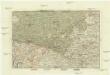
Der Rheinstrohm von Basel bis Maynz
1 : 620000 Basilej (Švýcarsko) Engelman, J.
Le theatre de la guerre sur le Haut Rhein
1 Karte : Kupferdruck ; 61 x 45 cm Nolin; Rousseau; Leonard chés I. B. Nolin geographe ordinaire du roy sur le quay de l'Horloge du palais a l'enseigne de la place des Victoires vers le Pont Neuf
Frontiere Franco-Allemande
1 : 320000 Francie
Theatrum Belli ad Rhenum Superior. nec non Munimentorum tum Imperialium, tum Gallicorum ichnographica exhibitio accurate tradita
1 : 375000 Mollova mapová sbírka Homann, Johann Baptist Homann, Johann Baptista - dědici


