Maps of Schemmerhofen

Biberach, Guttenzell, Munchrott, Buxheim a okolí]
Mollova mapová sbírka Bodenehr, Gabriel Bodenehr, Gabriel
Meßtischblatt [7826] : Kirchberg a. d. Iller, 1915
1 : 250000 Kirchberg a. d. Iller. - 1:25000. - Stuttgart, 1915. - 1 Kt.
Meßtischblatt [7825] : Schwendi, 1918
1 : 250000 Schwendi. - 1:25000. - Stuttgart, 1918. - 1 Kt.
Meßtischblatt [7926] : Erolzheim, 1915
1 : 250000 Erolzheim. - 1:25000. - Stuttgart, 1915. - 1 Kt.
Meßtischblatt [7925] : Ochsenhausen, 1918
1 : 250000 Ochsenhausen. - 1:25000. - Stuttgart, 1918. - 1 Kt.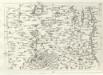
Geographica Provinciarum Sveviae Descriptio =
Mollova mapová sbírka Hurter, Johann Christoph Bodenehr, Johann Georg
179. Ulm, uit: Topographische Uebersichtskarte des Deutschen Reiches / herausgegeben v. d. Kartogr. Abt. d. Königl. Preuß. Landesaufnahme
1 : 200000 titelvariant: Topogr. Übersichtskarte des Deutschen Reiches; Annotatie: Titel boven bladen ook: Topogr. Übersichtskarte des Deutschen Reiches; Annotatie geografische gegevens: Op elk blad twee maatstokken: 10 Kilometer = 5,5 cm; 1 geogr. Meile = 3,6 cm; Legenda onder op elk blad Königlich Preußische Landesaufnahme. Kartographische Abtheilung [S.l : Königlich Preußische Landesaufnahme, Kartographische Abtheilung]
Umgegend von Ulm
1 : 200000 Kartographischen Abtheilung konigl Preuss
Suevia universa IX. tabulis delineata, 6
1 Blatt : s.n.
Ulm 142, uit: [W. Liebenow's Special-Karte von Mittel-Europa]
1 : 300000 titelvariant: W. Liebenow's Mittel-Europa; Annotatie: Titel boven de bladen: W. Liebenow's Mittel-Europa Johannes Wilhelm Liebenow 1822-1897 Hannover : Hermann Oppermann
Ulm 142, uit: Special-Karte von Mittel-Europa / nach amtlichen Quellen bearbeitet von W. Liebenow
1 : 300000 titelvariant: W. Liebenow's Mittel-Europa; Annotatie: Titel boven de bladen: W. Liebenow's Mittel-Europa Johannes Wilhelm Liebenow 1822-1897 Frankfurt a. M. : Ludwig Ravenstein
Suevia Universa :
1 : 170000 Mollova mapová sbírka Michal, Jacques de Seutter, Matthäus Seutter, Matthäus
Suevia Universa :
1 : 170000 Mollova mapová sbírka Michal, Jacques de Seutter, Matthäus Seutter, Matthäus
Die Lande der Grafen Fugger
1 Karte : Kupferdruck ; 20 x 25 cm Reilly F. J. J. von Reilly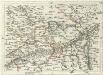
Geographica Provinciarum Sveviae Descriptio =
Mollova mapová sbírka Hurter, Johann Christoph Bodenehr, Gabriel
Die Lande der Grafen Fugger mit den Herrschaften Thannhausen, Schwabeck, und Mindelheim den Benachbarten Abteyen un der freyen Reichsstadt Kaufbeuren
1 : 245000 Švábsko (Německo)
Ehingen, Weissenhorn a okolí]
Mollova mapová sbírka Bodenehr, Gabriel Bodenehr, Gabriel
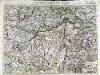
Territorium der des H. R. R. Statt Memmingen samt denen angräntzenden Herrschafften.
1 : 2800 Mollova mapová sbírka Bodenehr, Gabriel Bodenehr, Gabriel
Meßtischblatt [7824] : Warthausen, 1915
1 : 250000 Warthausen. - 1:25000. - Stuttgart, 1915. - 1 Kt.
Meßtischblatt [7924] : Biberach, 1915
1 : 250000 Biberach. - 1:25000. - Stuttgart, 1915. - 1 Kt.
Suevia universa IX. tabulis delineata, 5
1 Blatt : s.n.
Le Theatre de Bellone :
Mollova mapová sbírka Schenk, Pieter Braakman, Adriaan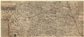
Ilerae Amnis ac Vtrinqve adiacentis Alemanniae Geographica descriptio
1 : 120000 Mollova mapová sbírka Hurter, Johann Christoph Custos, Raphael Hurter, Christoph
Carte topographique d'Allemagne contenant une partie de Baviere les principautés de Wurtemberg, d'Oettingen
1 Karte : Kupferdruck ; 45 x 63 cm Jaeger se vend chez l'auteur
Per Inclyti Circuli Suevici Supremorum Ordinum :
1 : 160000 Mollova mapová sbírka Pfeffel, Johann Andreas Pfeffel, Johann Andreas I.
Per Inclyti Circuli Suevici Supremorum Ordinum
1 : 160000 Mollova mapová sbírka Pfeffel, Johann Andreas Homann, Johann Baptista - dědici
Totius S. R. I. Circuli Suevici Tabula Chorographica
1 : 310000 Mollova mapová sbírka Lamsvelt, Jan Ottens, Josua
Generalkarte von Württemberg: Blatt IV
1 : 1500000 Terrainzeichnung: Bach, Topograf und Hauptmann Lithografie: Rebmann und Sommer Herausgeber: K. statistisch-topografisches Büro
![Biberach, Guttenzell, Munchrott, Buxheim a okolí]](https://images-0.georeferencer.com/images/iiif/678893751839/full/,300/0/native.jpg)

