Maps of Jura

Le Theatre de Bellone :
Mollova mapová sbírka Schenk, Pieter Braakman, Adriaan
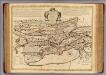
[Exactissima Helvetiae, Rhaetiae, Valesiae ... tabula]
1 : 850000 9 Karten [Kopie von Adrian Braakman] [chez Pierre Schenk et Adrian Braakman], [Amsterdam]
Département du Jura
1 Karte : Kupferdruck ; 49 x 48 cm Houdan; Dumez chez Dumez directeur de l'Atlas national rue de la Harpe no. 26
Lausanne
1 : 200000 1 Karte entworfen und bearbeitet von Woerl ; in Stein gestochen unter seiner Leitung 1835 ; Lithographie von B. Herder Herder, Freiburg im Breisgau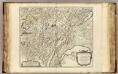
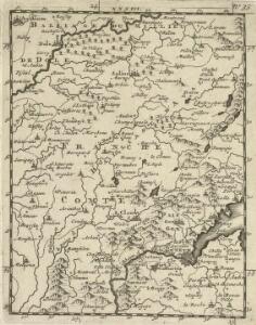
Comte de Bourgogne sud.
1 : 237500 Robert de Vaugondy, Gilles, 1688-1766
Partie méridionale du comté de Bourgogne ou Franche-Comté
1 Karte : Kupferdruck ; 46 x 55 cm Robert de Vaugondy G. et D. Robert de Vaugondy
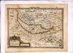
Sequani
1 Karte : Kupferdruck ; 42 x 55 cm Sanson; Robert de Vaugondy; Somer chés le S Robert geographe ord. du roy quai de l'Horloge du Palais
Département du Jura
1 : 260000 Jura (Francie) Houdan, François d' P. G. Chanlaire
Département du Jura
1 Karte : Kupferdruck ; 40 x 35 cm Capitaine s.n.
[Atlas départemental : La France et ses colonies] No. 38 Jura
1 : 670000 publ. par Michel fils ainé [dressé par A. Lorrain, et gravé par H. Dandeleux] Versailles [etc.] : Barreswil et Andrieux
Dept. Du Jura.
1 : 571000 Levasseur, Victor.
Sequani. Archidne. de Salins du Dioecese de Besancon
1 : 240000 Mollova mapová sbírka Sanson, Nicolas Somer, Jean Pruthenus Sanson, Guillaume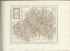
Neuchatel, Vallangin.
1 : 100000 L'Isle, Guillaume de, 1675-1726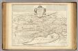
Neuchatel, Vallangin.
1 : 100000 Merveilleux, David Francois de
<<Le>> canton de Genève
1 : 150000 1 Karte D. v. Escher del. ; J.J. Scheurmann sc. [Orell Füssli & Comp.], [Zürich]
Carte du lac de Geneve et des pays circonvoisins
1 Karte auf 2 Blatt : Kupferdruck ; 55 x 80 cm Rovéréa; Fatio de Duillier; Daudet; Chopy Antoine Chopy
Pontarlier, Yverdon
1 : 100000 1 Karte par Aug. Jaccard [Wurster & Randegger], [Winterthur]
Genève, Lausanne
1 : 100000 1 Karte par Aug. Jaccard [Wurster & Randegger], [Winterthur]
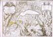
Lacvs Lemanni locorvmqve circvmiacentivm accvratissima descriptio
1 Karte : Kupferdruck ; 41 x 53 cm Goulart; Blaeu apud Guiljelmum Blaeu
Lacvs Lemani vicinorvmq. locorvm nova et accvrata descriptio
1 Karte : Kupferdruck ; 35 x 47 cm Hondius Judocus Hondius excudit

Topographische Karte der Schweiz
1 : 100000 25 Karten vermessen und hrsg. auf Befehl der Eidgenössischen Behörden ; aufgenommen unter der Aufsicht des Generals G.H. Dufour Eidg. Topographisches Bureau, [Genève], [später: Bern]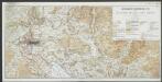
Lacus Lemanni Locorumque Circumiacentium Accuratissima Descriptio. [Karte], in: Le théâtre du monde, ou, Nouvel atlas contenant les chartes et descriptions de tous les païs de la terre, Bd. 2, S. 80.
1 Karte aus Atlas Blaeu, Willem Janszoon und Blaeu, Joan Blaeu, Willem Janszoon
Topographische Karte der Schweiz
1 : 100000 25 Karten vermessen und hrsg. auf Befehl der Eidgenössischen Behörden ; aufgenommen unter der Aufsicht des Generals G.H. Dufour Eidg. Topographisches Bureau, [Genève], [später: Bern]
Lacus Lemanni Locorumque Circumiacentium Accuratissima Descriptio. [Karte], in: Theatrum orbis terrarum, sive, Atlas novus, Bd. 2, S. 160.
1 Karte aus Atlas Blaeu, Joan Blaeu, Willem Janszoon
Lacus Lemanni Locorumque Circumiacentium Accuratissima Descriptio. [Karte], in: Novus Atlas, das ist, Weltbeschreibung, Bd. 2, S. 82.
1 Karte aus Atlas Blaeu, Joan Blaeu, Willem Janszoon
LACVS LEMANNI | LOCORVMQVE CIRCVM- | IACENTIVM ACCVRATIS- | SIMO DESCRIPTIO
Auctore | IACOBO GOVLARTIO GENEVENSI. Apud Guiljelmum Blaeu.