Maps of Netherlands

Postarum seu Veredariorum Stationes Per Germaniam et Provincias Adiacentes.
1 : 400000 Mollova mapová sbírka Danckerts, Justus Danckerts, Cornelis
Pas-caert van Texel tot aen de Hoofden
1 Karte : Kupferdruck ; 43 x 53 cm Doncker bÿ Hendrick Doncker boekverkoper en graadbooghmaker in de Nieubrugsteegh in 't Stuurmans gereetschap
L'Empire, d'Allemagne
1 : 1200000 Mollova mapová sbírka Sanson, Nicolas Quasy, Robert
Neue und richtige Landtafel der XVII Niderländische Provincien : abbildende alle befestigte, bemauerte, offene Stedte und Schantzen, etc.
1 : 1260000 Annotatie geografische gegevens: Noordwest boven Nürnberg : Jacob Sandrart
Summaria descriptio Fresiae Universae, cum latissime patuit nomen post emigrationem Francorum, Saxonumq. accessionem
auctore Mensone Alting Gerard de Broen fecit Amstelodami. [Amstelaedami] : [apud Henricum Wetstenium]
L'Alemagne 1.
1 : 1800000 Rizzi Zannoni, Giovanni Antonio Bartolomeo, 1736-1814
Charte über die saemtlichen zum Westphaelischen Kreis gehörige Laender
1 : 840000 Evropa severozápadní Güssefeld, Franz L. bey den Homaennischen Erben
Nouvelle carte geographique des postes des Pais Bas, de la Westphalie, & des provinces limitrophes
1 : 1
Bez titulu: Severozápadní Evropa

Holland or the United Provinces.
from A new systeme of the mathematicks: containing I. Arithmetick, as well natural and decimal, as in species, or the principles of algebra. II. Practical geometry, together with the first six books of Euclid's Elements, as also the eleventh and twelfth, symbo
[Königreich der Niederlande]
Neuester Schul-Atlas Walch, Johann im Verlag bei Joh. Walch
S. North Sea ports.
1 : 1500000 Philip, George
Europe Centrale (Partie Occidentale).
1 : 1750000 Jouvet et Cie.
Belgii Veteris Typus
1 : 1400000 Mollova mapová sbírka Ortelius, Abraham Visscher, Claes Jansz.
Belgii Veteris Typus
1 : 1400000 Mollova mapová sbírka Ortelius, Abraham Visscher, Claes Jansz.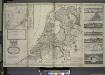
A new and exact map of the United Provinces, or Netherlands &c.
from The world described, or, A new and correct sett of maps : shewing the kingdoms and states in all the known parts of the earth, with the principal cities, and most considerable towns in the world ... / ... by Herman Moll, geographer ...
Les dix-sept provinces des Pays-Bas
1 : 1240000 Belgie Sanson, Guillaume Cordier, Louis chez H. Iaillot
Descriptio veteris agri Batavi et Frisii omnisque regionis quae hodie est in dicione VII. Foederatorum cis et ultra Rhenum
1 : 950000 auctore Mensone Alting. [Amstelaedami] : [apud Henricum Wetstenium]
Galliæ antiquæ descriptio geographica, 2
1 Blatt : 44 x 57 cm s.n.
Il Corso del Fivme Reno d'Allemagna, dalla Mosella fino al Mare. con tuttu li Dominij che si trouano nelle uicinanze del medesimo Fiume, rappresentati conforme lo stato presente da Giacomo Cantelli da Vignola Geografo del Ser.mo Sig. Dvca di Modena etc. 1689
Mollova mapová sbírka Cantelli, Giacomo Barbey, Antonio De Rossi, Giovanni Giacomo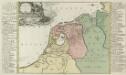
Summaria Descriptio Fresiae Vniversae; cum latissimè patuit nomen Post emigrationem Francorvm; Saxonvmq; accessionem
1 : 1400000 Mollova mapová sbírka Alting, Menso Broen, Gerrit de
Holland und Berg
Allgemeiner Atlas [Walch, Johannes] im Verlag bei Johannes Walch

Belgii Veteris Typus [...] [Karte], in: Gerardi Mercatoris et I. Hondii Newer Atlas, oder, Grosses Weltbuch, Bd. 1, S. 361.
1 Karte aus Atlas Mercator, Gerhard und Hondius, Jodocus Jansson, Jan
Naauwkeurige kaart van het oude Nederland en eenige aangrenzende gewesten.
1 : 2000000 Isaak Tirion. Te Amsterdam : by Isaak Tirion
Rheinprovinz, Westphalen, Holland und Belgien
Schul-Atlas in 36 Karten Völter, Daniel Verlag der J.M. Dannheimer'schen Buchhandlung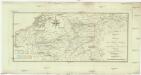
Charte von dem Schiefer Gebirge des nordwestlichen Deutschlands Belgiens und des nordöstlichen Frankreichs
1 : 1150000 Ardeny Raumer, Carl von Guimpel, F.
Belgii Veteris Typus. [Karte], in: Theatrum orbis terrarum, S. 470.
1 Karte aus Atlas Ortelius, Abraham Vrients, Jan Baptista
Kriegs Expeditions Karte von Devtschland
1 : 1700000 Mollova mapová sbírka Rizzi Zannoni, Giovanni Antonio Homann, Johann Baptista - dědici


