Maps of Rhineland-Palatinate
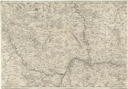
Totius Rheni â fontibus usque ad Ostia Novissima Descriptio
1 : 550000 Mollova mapová sbírka Steudner, Johann P. Bodenehr, Johann Georg Steüdner, Johann Philipp
Vollständige Carte des gantzen Rhein Stroms]
1 : 840000 Mollova mapová sbírka Riegel, Christoph Riegel, Christoph
Carte des Pais qui sont situez éntre la Moselle, la Saare, le Rhein, et la Basse Alsace
1 : 260000 Mollova mapová sbírka Sanson, Guillaume Jaillot, Alexis Hubert
Carte de Pais situéz entre la Moselle, La Saare, Le Rhein, Et La Basse Alsace [...] [Karte], in: Atlas nouveau, contenant toutes les parties du monde [...], Bd. 1, S. 232.
1 Karte aus Atlas Sanson, Nicolas Jaillot, Alexis Hubert und Mortier, Pieter
S.R.I. Circulus Rhenanus Inferior Sive Electorum Rheni
1 : 620000 Mollova mapová sbírka Homann, Johann Baptist Homann, Johann Baptista
S.R.I. Circulus Rhenanus Inferior Sive Electorum Rheni
1 : 620000 Alsasko (Francie) Homann, Johann Baptist â Ioh. Baptista Homanno
Plan des neien Kostranhren Wegs aus Carnte über den Loibl, von Seite miternacht anzusehen
Mollova mapová sbírka Geyer
Cursus Rheni a Basilea usque ad Bonnam, III. sectionibus exhibitus
1 : 258000 Basilej (Švýcarsko) Delisle, Guillaume per Homannianos Heredes
Cursus Rheni a Basilea usque ad Bonnam, III. sectionibus exhibitus
1 : 258000 Basilej (Švýcarsko) Delisle, Guillaume per Homannianos Heredes
Le cours du Rhin depuis Worms, jusqua Bonne et les pays adjaces / par Guillaume de l'Isle
1 : 220000 Isle, Guillaume de l' [Paris : Ph. Buache]
Archiepiscopatus Trevirensis Descriptio nova. [Karte], in: Gerardi Mercatoris et I. Hondii Newer Atlas, oder, Grosses Weltbuch, Bd. 1, S. 197.
1 Karte aus Atlas Mercator, Gerhard und Hondius, Jodocus Jansson, Jan
[Kaart], uit: Wyld's new map of the Rhine, from Rotterdam to Cologne, Coblenz, Mainz, Mannheim and Schrök : shewing every object interesting to the tourist
1 : 200000 London : Ja[me]s Wyld
Das Kriegstheater an der Rhein & Mainlinie
1 : 990000 Porýní-Falc (Německo) Meyer, A. litogr. Maschinendruck von A. Meyer
Charte des Rhein-Stroms von Breisach bis Linz auch als Post- u. Reise-Charte der umliegenden Länder brauchbar
1 : 617000 Breisach am Rhein (Německo) Streit, Friedrich Wilhelm Joseph Engelmann
1. Asperula cynanchica
Německo Lith. Anst. v. Wickelmann & Söhne
Circulus Franconicus ad occidentem vergens
1 Karte : Kupferdruck ; 37 x 32 cm Weigel; Kauffer Christoph Weigel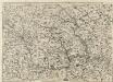
Abris Des Rheinstroms
Mollova mapová sbírka
PALATINATVS | AD RHENVM.
Apud Guiljelmum Blaeu
Palatinatus Ad Rhenum [Karte], in: Novus Atlas, das ist, Weltbeschreibung, Bd. 1, S. 267.
1 Karte aus Atlas Blaeu, Joan Blaeu, Willem Janszoon
Germania Prima sive Superior cujus Metropolis Moguntiacum
1 : 875000 Mollova mapová sbírka Sanson, Guillaume Sanson, Guillaume
Palatinatus Ad Rhenum. [Karte], in: Novus atlas absolutissimus, Bd. 2, S. 189.
1 Karte aus Atlas Janssonius Offizin
Karte des Rheinlaufes von Mannheim bis Düsseldorf von der Bergstrasse, den Main- und Lahn- Gegenden und den Bädern am Taunus
1 : 290000 Düsseldorf (Německo) Hoffmeister, F.L. Engelmann, Joseph Joseph Engelman

Le Palatinat Et Electorat Du Rhein Avec les Päis Voisins. [Karte], in: Atlas nouveau, contenant toutes les parties du monde [...], Bd. 1, S. 176.
1 Karte aus Atlas Sanson, Nicolas Jaillot, Alexis Hubert und Mortier, Pieter
L'electorat de Mayence partie de la Hesse et du palatinat du Rhin
1 Karte : Kupferdruck ; 54 x 48 cm Le Rouge chez le Rouge ruë des Augustins vis a vis le Panier fleuri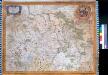
Palatinatvs Ad Rhenvm. Pfaltz. Heidelberg
Stenglin, Emanuel
Palatinatus Ad Rhenum [Karte], in: Theatrum orbis terrarum, sive, Atlas novus, Bd. 1, S. 257.
1 Karte aus Atlas Blaeu, Joan Blaeu, Willem Janszoon
Palatinatus Rheni nova et accurata descriptio / magna cura in lucem editum per Nicolaum Joannis Piscatorem
1 : 450000 Annotatie: Met stadsgezichten boven de kaart op Mentz en Francfurt am Main, onder op Spier, Heydelberg, Wormbs, links op Arcis Electoralis Palatinae delineatio, Dolium enormae magnitudinis, Neuberg Closter, rechts op Heyligenberg en Wolfs Brunnen; links en rechts elk 2 afb. van klederdrachten, rechts 1 wapen en onder 2 wapens; Origineel is Blad 109 in atlas factice Claes Jansz. Visscher 1586/1587-1652 [Amsterodami] : [Nicolaus Joannis Piscator]
Palatinatus Ad Rhenum [Karte], in: Le théâtre du monde, ou, Nouvel atlas contenant les chartes et descriptions de tous les païs de la terre, Bd. 1, S. 296.
1 Karte aus Atlas Blaeu, Willem Janszoon und Blaeu, Joan Blaeu, Willem Janszoon