Maps of Austria

Circuli Austriaci in quo Sunt Archiducatus Austriae Ducatus Stiriae Carintiae Carniolae et Episcopatus Tridentini Novissima Descriptio
1 : 900000 Mollova mapová sbírka Danckerts, Justus Danckerts, Justus
Vetvs Avstria Cisdanvbiana Norica
1 : 2160000 Mollova mapová sbírka Clüver, Philipp Fuhrmann, Mathias
Circuli Austriaci in quo sunt archiducatus Austriae ducatus Stiriae Carintiae Carniolae comitatus Tirolis et episcopatus Tridentini novissima descriptio
1 : 920000 Evropa střední Danckerts, Justus per Iustinum Danckerts
Vindové
Chorvatsko Müller, Jos. D. Jungmann, C.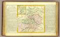
Cercle d'Autriche.
1 : 1450000 Clouet, J. B. L. (Jean-Baptiste Louis), b. 1730
Circvli Avstriaci Pars posterior et principalis complectens Archid. Austriae Ducatus Styriae Carinthiae et Carniolae
1 : 2600000 Mollova mapová sbírka Franz, Johann Michael Homann, Johann Baptista - dědici
Süd-östliches Deutschland
1 : 1850000 Evropa jihovýchodní Stieler, Adolf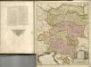
Circuli Austriaci
1 : 910000 1 Karte : Kupferdruck ; 48 x 57 cm Danckerts, Justus [Danckerts]
Wnitro-rakauské země
Chorvatsko
Teutschlandes Oesterreichischer Creiss
1 : 3700000 Mollova mapová sbírka Weigel, Johann Christoph Weigel, Johann Christoph
Der oesterreichische Kreis ohne die Vorlande
1 Karte : Kupferdruck ; 50 x 63 cm Mannert in der kais. priv. Kunsthandlung Adam Gottl: Schneider u: Weigel
Charte von Innerostreich od. den Herzogthumern Steyermark, Kaernten u. Krain, mit den Gebiethen v. Gorz u. Triest
1 : 650000 Chorvatsko Streit, Friedrich Wilhelm Liechtenstern, Joseph Marx von
Die Provinz Inner-OEsterreich oder die Herzogthümer Steyermark, Kaernten und Krain, die Grafschaften Goerz und Gradisca und das deutsch-oesterreichische Litorale
1 : 740000 Gorice a Gradiška Kindermann, Joseph Karl Junker, Christoph Franz Xaver Miller
Karnthen, Krain, Gorz-Gradisca, Istrien, Triest.
1 : 875000 Flemming, Carl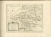
Partie du cercle d'Austriche ou sont les duchés de Stirie, de Carinthie, de Carniole et autres estats hereditaires a la maison d'Austriche
Kärnten, Steiermark Sanson, Guillaume ; Jaillot, Alexis Hubert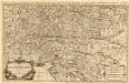
Partie du Cercle d'Austriche, ou sont Les Duchés de Stirie, de Carinthie, de Carniole
1 : 650000 Mollova mapová sbírka Sanson, Guillaume Jaillot, Alexis Hubert
Vogels Karte des Deutschen Reichs und der Alpenländer
1 : 500000 Augsburg-oblast (Německo) Vogel, Karl Langhans, Paul Justus Perthes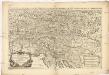
Partie du cercle d'Austriche, ou sont les duchés de Stirie, de Carinthie, de Carniole et autres estats heriditaires a la maison d'Austriche
1 : 630000 Korutansko (Rakousko) Sanson, Guillaume Jaillot, Alexis-Hubert H. Iaillot
St. Lucia und die Luzien-Percht am Südostrande der Alpen
Österreich, Slowenien, Volkskunde Umschaden, Kurt ; Neunteufl, Walter
Oesterreich. Alpenlander.
1 : 1125000 Andree, Richard
Austrian Alps.
1 : 1125000 Andree, Richard; Times (London, England)
Blatt VI, uit: Geologische Übersichts-Karte der Österreichisch-Ungarischen Monarchie / nach den Aufnahmen der K.K. Geologischen Reichsanstalt bearb. von Franz Ritter von Hauer ; gezeichn. von Eduard Jahn
1 : 576000 Annotatie geografische gegevens: Gebaseerd op veldwerk in de jaren 1850 tot 1865 Hauer, Franz Ritter von; Jahn, Eduard; Kaiserlich-Königliche Geologische Reichsanstalt, Wenen Wien : Beck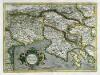
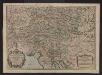
Forvm Ivlivm, Karstia, Carniola, Histria et Windorvm Marchia
1 Karte : Kupferdruck ; 33 x 45 cm Mercator; Hondius Henricus Hondius
Forvm Ivlivm, Karstia, Carniola, Histria et Windorvm Marchia
1 Karte : Kupferdruck ; 33 x 45 cm Mercator s.n.
Forvm Ivlivm, Karstia, Carniola, Histria et Windorvm Marchia
1 Karte : Kupferdruck ; 33 x 45 cm Mercator s.n.
Die Provinz Inneroesterreich oder die Herzogthümer Steyermark, Kaernten und Krain, die Grafschaften Goerz und Gradisca und das deutsch-oesterreichische Litorale
1 : 730000 Gorice a Gradiška Kindermann, Joseph Karl Junker, Christoph Franz Xaver Miller
Karte von Inneroesterreich oder das Herzoghtum Steyermark, Kaernthen und Krain
1 : 1080000 Korutansko (Rakousko) T. Mollo


