Maps of Albania

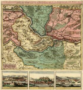
Nieuwe en Accurate Caart van de Omleggende Lande van Belgrado, ale mede des selss Belegeringh, ende Marse der Keyserlyke Armée A. 1717
1 : 500000 Mollova mapová sbírka Ottens, Joachim Ottens, Joachim
98. Albania. The World Atlas.
1 : 1250000 USSR (Union of Soviet Socialist Republics).
Černá Hora, Sandžak Novopazarský se západní hranicí Srbska, západní pole bitevní na Balkáně
1 : 580000 Novi Pazar (Srbsko) Maxim
Neubertova podrobná příruční mapa Abanie

Gewässerkarte von Albanien
Albanien Hydrologie Péch, Béla
Map of Albania.
1 : 865000 Melish, John
Karte von Albanien
1 : 600000 Albánie Kartogr. Anstalt G. Freytag & Berndt
Albanie - Monténégro: Structure Physique et Routes
Albanien Montenegro Geländedarstellung Verkehrsweg
Carte generale
Albanien
Albania
1 : 500000 Albánie Consociazione turistica italiana
Carte de la Haute Albanie ou Guegaria. Comprenant le Pachalik de Scutari avec une partie de ceux de Monastir et de Prisren
Shkodër Ejalet
Nord- und West-Albanien nach den Beobachtungen des k.k. Kreisphysikers Dr. J. Müller 1844
Albanien
Albanisches Insurrectionsgebiet 1444
1 : 2500000 Albanien Aufstand
Shqiperia
1 : 500000 Albánie
Atlas
Albanien
Totius Graeciae descriptio
Griechenland Albanien
Carte d'une partie de la Servie et de l'Albanie
1 : 800000 Albánie Lapie, Pierre Schwaerzlé, J. Société géologique de France
G. Freytags Karte des Fürstenthums Albanien
1 : 600000 Albánie Freytag, Gustav Kartogr. Anstalt G. Freytag & Berndt
Carte de l' Albanie
Albánie Karacsay, Fedor
Tabula Peutringeriana
Albanien Peutingersche Tafel
Atlas
Albanien
Speculum orbis Terrarum
Albanien
Albanie (Races et Religions)
Albanien Ethnische Gruppe Denomination
Generalkarte
Albanien
[Nordalbanien]
Albanien
The Towns of Albania (as of 4 March, 1989)
Albanien Städtenetz
Albánie

Urban Growth, 1965-1987
Albanien Städtewachstum
Turquie d'Europe
Albanien Osmanisches Reich Reich