Maps of Cuneo

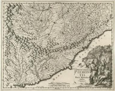
Principatus Piemontis Pars Meridionalis
1 : 490000 Mollova mapová sbírka Homann, Johann Baptist Homann, Johann Baptista
Riuiera di Genova da Ponente
1 : 450000 Mollova mapová sbírka Magini, Giovanni Antonio Wright, Benjamin Magini, Fabio
Riviera Di Genova Da Ponente [Karte], in: Le théâtre du monde, ou, Nouvel atlas contenant les chartes et descriptions de tous les païs de la terre, Bd. 3, S. 48.
1 Karte aus Atlas Blaeu, Willem Janszoon und Blaeu, Joan Blaeu, Willem Janszoon
Riviera di Genova di Ponente
1 : 400000 Annotatie: In tegenstelling tot eerdere uitgaven van Johannes Janssonius bevat deze kaart een afwijkend cartouche in de vorm van een afbeelding van Neptunus geflankeerd door paarden en putti, waarbij 1 van de putti een banier vasthoudt met daarop de titel van de kaart; In tegenstelling tot latere uitgaven door Schenk & Valk ontbreekt de kompasroos en het impressum van Schenk en Valk; Origineel is Blad 156 in atlas factice; Annotatie geografische gegevens: Schaalstokken op de kaart: 10 milliaria Italica communia (= 4,1 cm) en: 2 mill. Ger. communia (= 3,6 cm) [S.l.] : [s.n.]
Riviera Di Genova Di Ponente [Karte], in: Novus atlas absolutissimus, Bd. 5, S. 99.
1 Karte aus Atlas Janssonius Offizin

RIVIERA | DI GENOVA DA | PONENTE
[Amsterdam : Joan Blaeu]
Partie Meridionale du Piemont et du Monferrat
1 : 270000 Mollova mapová sbírka Delisle, Guillaume Desrosiers, F. L'Isle, Guillaume de
Piemont, Monferrat meridionale.
1 : 275000 L'Isle, Guillaume de, 1675-1726
Piemont, Monferrat meridionale.
1 : 275000 L'Isle, Guillaume de, 1675-1726
S. Remo - Ospedaletti - Bordighera
1 : 200000 Janov (Itálie) Ente nazionale per le industrie turistiche ferrovie dello stato
La Principauté de Piemont, Les Marquisats de Saluce et de Suze, les Comtés de Nice et d'Ast, le Montferrat &c
1 : 250000 Mollova mapová sbírka Jaillot, Alexis-Hubert Jaillot, Alexis Hubert
Karte von dem Herzogthume Savoyen und den Grafschaften Nizza, Tenda und Boglio oder den Ländern welche der König. von Sardinien in dem Frieden zu Paris den 15 May 1796 der Französischen Republik abtrat
1 : 421000 Nice (Francie) Reilly, Franz Johann Josef von F.I.I. von Reilly
Carte du Piemont et du Monferrat
1 : 350000 Mollova mapová sbírka Placide de Sainte-Hélène
Carte de la ville de Genes, et des environs
1 : 80000 Janov-oblast (Itálie) Gravier, Jean Mari Pallavicini comtesse d'Yevres, Livia de M. Albert & Gravier

Le Theatre de Bellone :
Mollova mapová sbírka Schenk, Pieter Braakman, Adriaan
Pedemontivm
Piemonte (Itálie)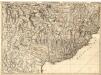
Environs de Barcelonette et de Beuil = Environs de Coni, Tende et Albenga
1 : 120000 Mollova mapová sbírka Dheulland, Guillaume Dheulland, Guillaume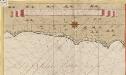
Een gedeelte van de kust van Provence in de Middelanse Zee tussen C. St. Remo en Caap delle Melle int groodt
Italy Gerard van Keulen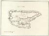
Castello di Savorgio
Mollova mapová sbírka
Pianta di Villa franca con parte della riviera di Gjenova
Mollova mapová sbírka
Parte del Piemonte
1 : 230000 Mollova mapová sbírka
Carte de la France... Feuille XXVII - 33

Carte de la France... Feuille XXVII - 32


Carta Topographica da Torino sino a Cuneoconsuoi camini fiumi Torenti et Seoladici
Mollova mapová sbírka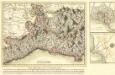
Kriegs- Schau- Platz in Italien in der Republic Genua
1 : 220000 Mollova mapová sbírka Lidl, Johann Jakob Lidl, Johann Jacob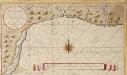
De reede van Vado int groot 1713
Italy Gerard van Keulen