Maps of Lombardy

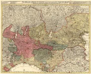
De Stoel des Oorlogs in Italien
1 : 750000 Mollova mapová sbírka Visscher, Nicolaes Anse, Luggert van Schenk, Peter II
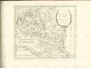
Longobardia Divisa in status suos
1 : 900000 Mollova mapová sbírka Wolf, Jeremias Wolff, Jeremias
Longobardia divisa in status suos qui sunt
1 : 910000 Lombardie (Itálie) Cantelli, Giacomo apud Tobiam Conrad Lotter
Le Theatre General de Guerre en Italiae
1 : 890000 Mollova mapová sbírka Nolin, Jean-Baptiste Nolin, Jean Baptiste II.
La Lombardie
1 : 730000 Mollova mapová sbírka Tralage, Jean-Nicolas de Nolin, Jean Baptiste
Le Duché De Milan dans Toute son estendüe Divisé En Ses Pricipales Parties Avec les Estats et Frontieres qui L'environnent. [Karte], in: Atlas nouveau, contenant toutes les parties du monde [...], Bd. 2, S. 153.
1 Karte aus Atlas Sanson, Nicolas Jaillot, Alexis Hubert und Mortier, Pieter
Karte des Königreiches Lombardie-Venedig
1 : 830000 Janov-oblast (Itálie) Raffelsperger, Franz im typographischen Landkarten-Verlage
Karte des Königreiches Lombardie-Venedig
1 : 830000 Benátky-oblast (Itálie) Raffelsperger, Franz Rumpold, F. im typographischen Landkarten-Verlage
Karte des Königreiches Lombardie-Venedig
1 : 840000 Benátky-oblast (Itálie) Raffelsperger, Franz Rumpold, F. im typographischen Landkarten-Verlage
Carta della Repubblica Italiana divisa in dipartimenti, ripartiti in distretti
1 : 1500000
L'Italie, aux environs du Po, ou se trouve les etats des ducs de Savoye, de Milan, de Mantoue, de Parme, de Modene, &c
1 : 308000 Mantova (Itálie) Fer, Nicolas de Danet, Guillaume Danet
Carta Generale del Regno d'Italia
Itálie severní Artaria
De stoel des oorlogs in Italien, waar in vertoont werden de staat van Milano, de republicen van Venetien en Genoua, de landen van Parma, Mantoua, Modena, Ferrara en andere met haare grensen, en het aanmerkelykste het geene hier nevens verklaart werd
1 : 700000 Benátsko (Itálie) Visscher, Nicolaes Jansz. Anse, Luggert van Nicolaus Visser
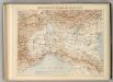
Karte vom Kriegsschauplatze in Ober-Italien
1 : 900000 Itálie severní C.W. Medau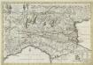
Italiae Galicae Sive Galliae Cisalpinae
1 : 300000 Mollova mapová sbírka Covens, Johannes Covens, Johannes I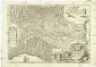
Statto di Milano e prouincie confinanti dalla parte orientale &
1 : 755000 Itálie severní Frattino, Giulio Carlo Surello, D.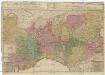
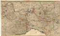
AREA ET ALEA BELLI
1 : 610000 Piemonte (Itálie) Valk, Gerhard ex officina G. Valk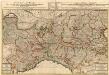
Area et Alea Belli
1 : 640000 Mollova mapová sbírka Valk, Gerhard Valck, Gerard
Lombardisch Venetianischen Koenigreich sam[m]t Parma und Modena
Lombardie (Itálie) S. B. V. A.
E.7. Mailand, uit: [Übersichtskarte von Europa 1:750.000]
1 : 750000 Wien : K.u.K. Militärgeographisches Institut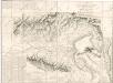
Carta delle stazioni militari, navigazione e poste del Regno d ́Italia...
Carte Physique et Militaire des Alpes et du Po.
1 : 970000 Jouvet et Cie.
Karte von der Cisalpinischen Republik
1 : 1070000 Itálie severní Reilly, Franz Johann Josef von F.J.J. von Reilly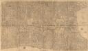
Geografia Particolare della Lombardia
1 : 490000 Mollova mapová sbírka Gastaldi, Jacobo Scolari, Stefano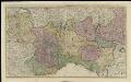
Status Sabaudici, tabulam in ducatum Sabaudiae, et Montisferrati, principatum Pedemontii, comitatum Nicaeensem, et caeteras partes minores
1 : 500000 Amsterdam : R. & J. Ottens
Status Sabaudici
1 : 660000 Mollova mapová sbírka Danckerts, Justus Danckerts, Justus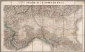
Théatre de la guerre en Italie
1 : 512000 Paris : Longuet