Maps of Kevelaer

Fossa quae a Rheno ad Mosam duci caepta est Anno MDCXXVII
1 : 120000 Mollova mapová sbírka Blaeu, Willem Janszoon Blaeu, Joan I.
FOSSA SANCTÆ MARIÆ | quæ EVGENIANA dicitur Vulgo De Nieuwe Grift.
Excudit Guilj. Janßonius Blaeuw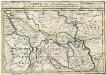
Geldern Eine Statt und Haupt Vestung im Hertzogthum gleiches Nahmens gelegen Mitt der Gegend auff 4 Stunden
1 : 340000 Mollova mapová sbírka Bodenehr, Gabriel Bodenehr, Gabriel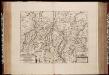
Fossa Eugeniana quae a Rheno ad Mosam duci coepta est, anno MDCXXII ductu comitis Henrici vanden Berge / [Joannes Janssonius]
1 : 80000 Annotatie: Het eerst verschenen in: Novus Atlas, das ist, Weltbeschreibung ... Zweite Theil. - Amsterdami : apud Iohannem Ianssonium, 1645; Origineel is Blad 66 in atlas factice; Annotatie geografische gegevens: Noordwest boven Janssonius, Joannes (jr.) (1588-1664) Amstelodami : sumptibus Ioannis Ianssonii
Fossa Eugeniana quae a Rheno ad Mosam duci coepta est, Anno CICICCXXVII ductu Comitis Henrici vanden Berge. [Karte], in: Novus atlas absolutissimus, Bd. 3, S. 103.
1 Karte aus Atlas Janssonius Offizin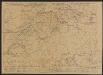
Fossa Eugeniana quae a Rheno ad Mosam duci coepta est, Anno CICICCXXVII ductu Comitis [...] [Karte], in: Gerardi Mercatoris et I. Hondii Newer Atlas, oder, Grosses Weltbuch, Bd. 1, S. 413.
1 Karte aus Atlas Mercator, Gerhard und Hondius, Jodocus Jansson, Jan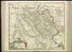
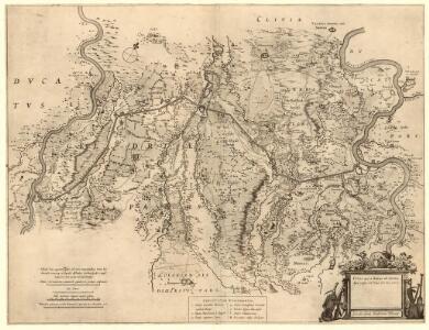
[62][62] Comitatus Meursensis ..., uit: Atlas sive Descriptio terrarum orbis
Annotatie: Gedigitaliseerde versie. Amsterdam. Heiloo : Picturae (vervaardiger), 2015. tiff-bestand. Gedigitaliseerd: 07-01-2015; Origineel: Universiteitsbibliotheek Vrije Universiteit (XL.05127.-) ; Netherlands; Titelpagina ontbreekt Wit, Frederik de Amsterdam : Frederick de Wit
Illustrissimo Celsissimoq; Principi Guilielmo Henrico D. G. Arausionum Principi Domino suo Clementissimo Hanc Comitatus Meursensis et Annexarum Dinastiarum Accuratam Tabulam humillime Offert
1 : 80000 Mollova mapová sbírka Heurdt, A. van Wit, Frederick
Mürs Comitatus [Karte] Mürs Oppidum et Arx [Nebenkarte] Modiliana. [Nebenkarte], in: Gerardi Mercatoris et I. Hondii Newer Atlas, oder, Grosses Weltbuch, Bd. 1, S. 211.
1 Karte aus Atlas Mercator, Gerhard und Hondius, Jodocus Jansson, Jan
Mürs Comitatus [Karte] Mürs Oppidum et Arx. [Nebenkarte] Modiliana. [Nebenkarte], in: Gerardi Mercatoris Atlas, sive, Cosmographicae meditationes de fabrica mundi et fabricati figura, S. 352.
1 Karte aus Atlas Mercator, Gerhard Montanus, Petrus
Delineatio & descriptio novi canalis, qui non ita pridem derivari cepit circa Rhenum in Mosam, quod opus ceptum 21. die septembris, anni 1626 & perductu[m] Rheinbergâ Geldriam usq., quatuor miliaria in longitudine, in latitudine 50. pedes, altera pars Geldriâ usq. Venloum (quae distantia pariter est circiter 4. miliaru[m]) ultra dimidiam partem fodiendo peracta, & quotidie perficitur
Geldern (Německo)
Germany 1:25,000, Geldern
Germany 1:25,000 , Series GSGS 4414. Great Britain. War Office. [London] : War Office
Germany 1:25,000, Geldern (Administrative Boundaries)
Germany 1:25,000 , Series GSGS 4414. Great Britain. War Office. [London] : War Office
Germany 1:25,000, Rheinburg
Germany 1:25,000 , Series GSGS 4414. Great Britain. War Office. [London] : War Office
Germany 1:25,000, Issum
Germany 1:25,000 , Series GSGS 4414. Great Britain. War Office. [London] : War Office
Messtischblatt 2573 : Mörs, 1926 Mörs
1 : 250000 Mörs. - Aufn. 1892, bericht. 1926. - 1:25000. - [Berlin]: Reichsamt für Landesaufnahme, 1926. - 1 Kt.
Messtischblatt 2572 : Nieukerk, 1910 Nieukerk
1 : 250000 Nieukerk. - Aufn. 1892, hrsg. 1894, bericht. 1907, einz. Nachtr. 1910. - 1:25000. - [Berlin]: Reichsamt für Landesaufnahme, 1910. - 1 Kt.
Messtischblatt 2572 : Nieukerk, 1894 Nieukerk
1 : 250000 Nieukerk. - Aufn. 1892. - 1:25000. - [Berlin]: Reichsamt für Landesaufnahme, 1894. - 1 Kt.
Messtischblatt 2571 : Straelen, 1893
1 : 250000 Straelen. - Aufn. 1892, hrsg. 1893, bericht. 1907. - 1:25000. - [Berlin]: Reichsamt für Landesaufnahme, 1907. - 1 Kt.
Meßtischblatt 2500 : Rheinberg, 1936
1 : 250000 Rheinberg. - Hrsg. 1893, bericht. 1926, einz. Nachtr. 1936. - 1:25000. - [Berlin]: Reichsamt für Landesaufnahme, 1936. - 1 Kt.
Meßtischblatt 2500 : Rheinberg, 1893
1 : 250000 Rheinberg. - Aufn. 1892. - 1:25000. - [Berlin]: Reichsamt für Landesaufnahme, 1893. - 1 Kt.
Meßtischblatt 2499 : Issum, 1910
1 : 250000 Issum. - Aufn. 1892, hrsg. 1893, bericht. 1906, einz. Nachtr. 1910. - 1:25000. - [Berlin]: Reichsamt für Landesaufnahme, 1910. - 1 Kt.
Meßtischblatt 2499 : Issum, 1893
1 : 250000 Issum. - Aufn. 1892. - 1:25000. - [Berlin]: Reichsamt für Landesaufnahme, 1893. - 1 Kt.
Meßtischblatt 2498 : Geldern, 1917
1 : 250000 Geldern. - Aufn. 1892, hrsg. 1894, Aufl.-dr. 1917. - 1:25000. - [Berlin]: Reichsamt für Landesaufnahme, 1917. - 1 Kt.
Meßtischblatt 2498 : Geldern, 1894
1 : 250000 Geldern. - Aufn. 1892. - 1:25000. - [Berlin]: Reichsamt für Landesaufnahme, 1894. - 1 Kt.
20 Meerlo, uit: De Tranchotkaart van het gebied tussen Maas en Rijn : Nederlands gedeelte
Annotatie: Omslagtitel; Facs. van het Nederlandse deel van de manuscriptkaart van het Rijnland vervaardigd o.l.v. Jean Joseph Tranchot, 1803-1820. - Gereduceerd van 1:20.000 tot 1:25.000 Jean Joseph Tranchot 1752-1815 [Maastricht : Stichting Maaslandse Monografieën]
14 Weeze, uit: De Tranchotkaart van het gebied tussen Maas en Rijn : Nederlands gedeelte
Annotatie: Omslagtitel; Facs. van het Nederlandse deel van de manuscriptkaart van het Rijnland vervaardigd o.l.v. Jean Joseph Tranchot, 1803-1820. - Gereduceerd van 1:20.000 tot 1:25.000 Jean Joseph Tranchot 1752-1815 [Maastricht : Stichting Maaslandse Monografieën]
OBSIDIO | RHINBERCÆ | ad vivum expressa cum suis dimensi- | onibus ex mandato Excellentissimi Fre- | derici Henrici Nasovii Principis. | Auraici opera celebris et ingeniosi | Artificis Petri Manteau et | Iacobi Culen-burgh | Anno 1633.
Amstelodami | ex Officina Nicolai Ioannis Visscher [i.e. Joan Blaeu]
RHENOBERCA | OBSESSA ET CAPTA | Armis | ORDINUM BELGICÆ FOEDERATÆ | Ductu | Ill.mi Principis MAVRITII NASSOVII | Arausionensium Principis, Naßaviæ | Comitis, etc. Anno 1601.
[Amsterdam : Joan Blaeu]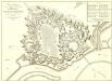
Plan Veritable de la Ville et Citadelle de Wesel
1 : 2900 Mollova mapová sbírka Le Rouge, Georges-Louis Martinet Le Rouge, Georges-Louis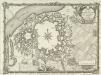
Plan de la Ville et Citadelle de Wesel En Westphalie
1 : 9000 Mollova mapová sbírka Martinet, G. Le Rouge, Georges-Louis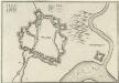
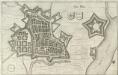
Weesell
Mollova mapová sbírka Merian, Caspar Merian, Caspar